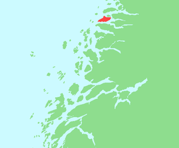
Åmnøya
 Location in Nordland | |
| Geography | |
|---|---|
| Location | Nordland, Norway |
| Coordinates | 66°46′12″N 13°20′28″E / 66.7700°N 13.3410°ECoordinates: 66°46′12″N 13°20′28″E / 66.7700°N 13.3410°E |
| Area | 23.4 km2 (9.0 sq mi) |
| Length | 10 km (6 mi) |
| Width | 4 km (2.5 mi) |
| Highest elevation | 648 m (2,126 ft) |
| Highest point | Risnestinden |
| Administration | |
| County | Nordland |
| Municipality | Meløy |
| Demographics | |
| Population | 129 (2001) |
Åmnøya is an island in the municipality of Meløy in Nordland county, Norway. The island lies west of the mainland, east of Bolga, and south of Meløya. The island is connected to the mainland by a series of small bridges over several small islands between Åmnøya and the village of Engavågen on the mainland. The island is very mountainous, the highest of which is the 648-metre (2,126 ft) Risnestinden.[1]
See also
References
- ↑ Store norske leksikon. "Åmøya" (in Norwegian). Retrieved 2012-02-06.
This article is issued from Wikipedia - version of the 11/10/2016. The text is available under the Creative Commons Attribution/Share Alike but additional terms may apply for the media files.