Ærø
 Marstal, largest town on the island | |
 | |
| Geography | |
|---|---|
| Location | Baltic Sea |
| Coordinates | 54°53′N 10°20′E / 54.883°N 10.333°ECoordinates: 54°53′N 10°20′E / 54.883°N 10.333°E |
| Area | 88 km2 (34 sq mi) |
| Administration | |
|
Denmark | |
| Region | South Denmark Region |
| Municipality | Ærø Municipality |
| Largest settlement | Marstal (pop. 2,266) |
| Demographics | |
| Population | 6,383 (2014) |
| Pop. density | 75.8 /km2 (196.3 /sq mi) |
.jpg)
Ærø (Danish pronunciation: [ˈɛːʁœːˀ]) is one of the Danish Baltic Sea islands, and part of the Southern Denmark Region. The name comes from the Danish words ær (maple) and ø (island).
Since 1 January 2006 the whole of Ærø has constituted a single municipality, known as Ærø Kommune. Before that date, there were two municipalities on the island: Ærøskøbing Kommune in the west and Marstal Kommune in the east.
Geography
- Population (in 2014): 6,383
- Area: 88 km2 (island); 91 km2 (municipality)
- Length of coastline: 167 km (104 mi)
Ærø measures roughly 20 km from northwest to southeast and varies in width from around 4 to 8 km. There are three small towns on the island: the largest is Marstal with a population of 2,266. Ærøskøbing has 925 inhabitants and Søby 496. Fourteen villages and a number of farms complete the island's pattern of settlement.
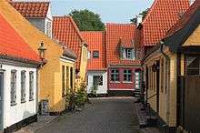
Ærøskøbing, with its narrow lanes and picturesque 18th-century houses was historically Ærø's chief town, and remains the primary port for ferry connections. Marstal, also known as the "skipper village", from its being the home of so many sailors and captains, is the island's largest town today and is its principal commercial and shopping centre.
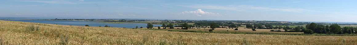
The countryside is for the most part gently undulating, and there is a several-kilometre-long stretch of 33-metre-high cliffs at Voderup Klint on the west coast. With its generally low traffic density, Ærø is a popular destination for hikers and cyclists. The island's beaches also attract anglers and artists. As one of the islands making up the South Funen Archipelago, Ærø is favoured by particularly fine weather. It enjoys a higher number of sunshine hours than the average for the rest of Denmark, and the year-round temperature is also a few degrees above the national average.
At Olde Mølle, at one of Ærø's highest points and near the centre of the island, the sculptor Erik Brandt has created a "peace bench", conceived with the intention of providing people with an opportunity to survey the island and its surrounding sea, whilst pondering on the theme of world peace.
History
Archaeological excavations provide evidence of settlements going back to before 8000 BC.[1] There are some burial mounds on the island, as well as an old Ting place. Relics of antiquity are found all over the island. Burial mounds, passage graves, and dolmens bear witness of human activity through more than 10,000 years.[1]
As for its more recent history, the period of the duchies is of special interest. During this period — from the 14th century to the year 1864 – Ærø was united and separated, alternately, into a number of enclaves.[1] Ærø was outside the tariff wall of the Kingdom, leading to flourishing smuggling which was a way of living for many of Ærø's inhabitants.
In 1629 the main town of Ærøskøbing burnt down in a great fire.[1] There was no other disaster of comparable scale. In 1750 the island, previously split into exclaves of numerous duchies, was united as single administrative district.[1]
Until 1864, Ærø was part of the Danish Duchy of Schleswig – the area of Schleswig/Southern Jutland is now divided between Denmark (Northern Schleswig) and Germany (Southern Schleswig). King Christian IV's cousin, also named Christian, was the Duke of Ærø from 1622 to 1633, and lived with his concubine Cathrine Griebels at Gråsten Manor House.[1]
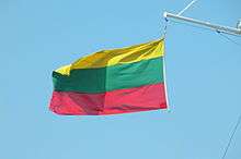
When the Duke died, a banner was found at Gråsten composed of nine pieces of cloth and in three colours – body colour, sea green, and golden yellow. This banner has provided the inspiration for the flag of Ærø which is seen today all over the island. When Duke Christian died, Ærø was distributed among four of his brothers, and this offers one explanation of why two towns developed in the island, Ærøskøbing and later on Marstal, and why each came to be in their own "country".
Gråsten Manor House was abolished in 1766 and the buildings were demolished.[1] The name of Gråsten is still alive today in the farmhouse that stands almost on the same spot as the ducal manor. Gråsten of today offers bed and breakfast accommodation.
In 1750, Ærø was united,[1] and has not since been separated. This is marked by the memorial stone at Olde Mølle (English = Ancient mill). At the union, the old Code of Jutland from 1241 was applied and even today some of those rules are still valid.
In recent history, the preservation of the area's local heritage has been paramount among residents. This passion for Ærø was demonstrated in 2000, when the Marstal Maritime School was ordered to close. More than 2,000 islanders (a third of the island) travelled to Copenhagen to protest the closing of the historic school. Ultimately, the government allowed the Maritime School to remain open.
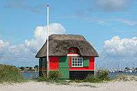 Beach hut, Marstal
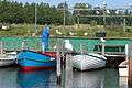 Strandbyen harbour, Ommel
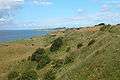 Voderup Klint cliffs
Technology
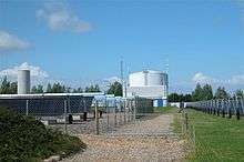
Ærø has the world's largest solar power plants, with an area of 18,365 m2. It provides a third of Marstal's power consumption.
Ærø is endeavouring to become self-sufficient in energy, and in 2002 a figure of 40% self-sufficiency in renewable energy was reached. The initiatives have attracted high international recognition and Ærø is considered to be one of the world's leaders in the field. As of January 2013, the solar plant covers an area of 33,300 m2 as a result of an extension under the Sunstore 4 project.[2]
Ærø's three district heating systems of solar collectors have won international acclaim. With the recent expansion, the system in Marstal is now the world's largest solar collector system for heating.
In 2002, three modern wind turbines were erected. The wing tip of these turbines is 100 m (330 ft) above the ground and between them the mills cover 50% of the island's electricity consumption.
28 January 2015 - The EU Horizon 2020 administration has confirmed that the 17 million € application for a demonstration E-ferry is now in the state of Grant Agreement - meaning that the partners in the Horizon application now have 3 months to finish contracting for the subsidies. The objective of the Green Ferry Vision is to perform a feasibility study for the design, production and operation of an innovative low weight ferry for cars and passengers - a ferry only powered by green electricity stored on batteries on board. The ferry design will be well beyond state-of-the-art when it comes to charging powers and capable operating distance. The ferry is to be completed in 2017 with Søby Værft as contractor.
Transport
Ærø is the only island among the larger Danish Baltic Sea islands that is not connected with a bridge, and road traffic is generally low. There are car ferry lines to Als, Funen and Langeland. Ærø also lies within a popular sailboat area, the South Funen Archipelago. A small airport with grassed runways is located near Marstal.
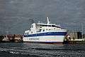
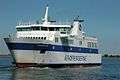 M/F Ærøkøbing, 1999- Ærøskøbing-Svendborg
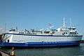 Søby-færgen, 1980- Søby-Fåborg
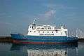 M/F Øen, 1993- Søby-Mommark
Notable residents
- Claus Lauritz Clausen (1820–1892), born in Ærø, Lutheran clergyman, organizer of United Norwegian Lutheran Church of America and missionary to America[3]
- Carsten Jensen, born in Marstal, Danish author and political columnist
Cultural references
- In his 2006 novel We, The Drowned – an epic tale spanning four generations, nearly one hundred years, and two world wars – Carsten Jensen describes the maritime history of Marstal, his native town, where the men were expected to go to sea and the women to be left behind.
See also
References
External links
| Wikivoyage has a travel guide for Ærø. |
| Wikimedia Commons has media related to Ærø. |
- Ærø Island International Website
- Ærø Island - Video and Photo archives
- Ærø Island - Community Portal
- Ærø Tourist Guide
- Ærø Portal
- Ærø Ferries
- Photos from Ærø