Île de Nantes
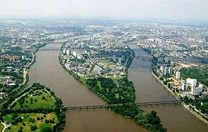
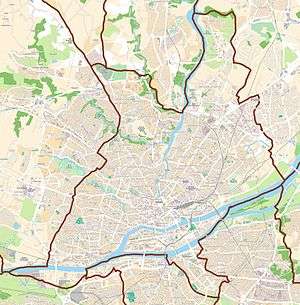
The "île de Nantes" (Island of Nantes) is an island located in the centre of the city of Nantes, France, surrounded by two branches of the Loire River - the "bras de la Madeleine" (branch of the Madeleine) at the north and the "bras de Pirmil" (branch of Pirmil) at the south. It is one of the eleven neighbourhoods of Nantes.
Overview
The island, 4.9 km (3.0 mi) long and 1 km (0.6 mi) wide, is the result of the reunion of a set of several small islands in the centre of Nantes, separated by the branches of the Loire river (sometimes referred to locally as the "Boire", as in "Boire des Récollets, the "boire de Toussaint" or even the "boire de la Biesse"). Those branches were closed during the 19th and 20th centuries. Among those islands, there were the "île Beaulieu", the "île Sainte-Anne", the "prairie au Duc", the "prairie d'Aval", the "prairie d'Amont", the "prairie de Balagué", the "prairie de Pré-Joli", the "île de Petite Biesse" and the "île de Grande Biesse".[1]
Access
The "île de Nantes" is linked to the rest of the city by 13 bridges:
- 8 bridges cross the branch of the Madeleine:
- Éric Tabarly bridge
- Résal bridge (railway bridge)
- Willy Brandt's bridge
- Aristide Briand bridge
- Général Audibert bridge
- Haudaudine bridge
- Passerelle Victor Schoelcher (pedestrian bridge)
- Anne-de-Bretagne bridge
- 5 bridges cross the branch of Pirmil:
- Léopold Sédar Senghor bridge
- Georges Clemenceau bridge
- Pirmil bridge
- Pornic bridge (railway bridge with a bicycle track)
- Trois continents bridge
The Vendée's bridge is a railway bridge, which crosses the island, but there is no railway station on the island.
Locations of interest
- Machines of the Isle of Nantes
- Court of justice of Nantes
- Titan cranes
- Blockhaus DY10
- The Palais des Sports de Beaulieu
- Buren's rings
- The hangar à bananes (bananas facility)
References
- ↑ (French) Map of the city of Nantes, municipal archives : http://www.archives.nantes.fr/PAGES/RESSOURCES/plans_numerises/plans_generaux.htm