Öræfajökull
| Öræfajökull | |
|---|---|
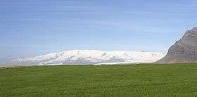 View of Öræfajökull, showing its broad shape. | |
| Highest point | |
| Elevation | 2,109.6 metres (6,921 ft) at Hvannadalshnúkur [1] |
| Prominence | 2,109.6 metres (6,921 ft) at Hvannadalshnúkur |
| Coordinates | 64°00′N 16°39′W / 64.000°N 16.650°W |
| Geography | |
| Location | Iceland |
| Parent range | Mid-Atlantic Ridge |
| Geology | |
| Age of rock | Pleistocene |
| Mountain type | Stratovolcano |
| Last eruption | 1727 to 1728 |

Öræfajökull (Icelandic pronunciation: [ˈœːraivaˌjœːkʏtl̥]) is an ice-covered volcano in south-east Iceland, at the southern extremity of the Vatnajökull glacier and overlooking the Ring Road between Höfn and Vík. It is the largest active volcano in the country, and on the summit crater's north-western rim is Hvannadalshnúkur, the highest peak in Iceland at 2,110 metres (6,920 ft). Geographically, Öræfajökull is considered part of Vatnajökull, and the area covered by glacier is within the boundary of Vatnajökull National Park.
Öræfajökull has erupted twice in historical times. In 1362, the volcano erupted explosively, with huge amounts of tephra being ejected. The district of Litla-Hérað was destroyed by floods and tephra fall. More than 40 years passed before people again settled the area, which became known as Öræfi. The name literally means an area without harbour, but it took on a meaning of wasteland in Icelandic. An eruption in August 1727-28 was smaller, though floods are known to have caused three fatalities.
See also
- Geography of Iceland
- Glaciers of Iceland
- Iceland plume
- List of lakes of Iceland
- List of islands of Iceland
- List of volcanoes in Iceland
- List of rivers of Iceland
- Volcanism in Iceland
- Waterfalls of Iceland
References
- ↑ "Hvannadalshnukur". Summitpost.com. Retrieved 2013-08-09.
External links
- Volcano Images of Europe
- Photos of Öræfajökull www.Icelandportfolio.com
- http://www.volcano.si.edu/world/volcano.cfm?vnum=1704-01=
