Újpalota
Újpalota is a panel housing estate in the 15th district of Budapest, Hungary.
History
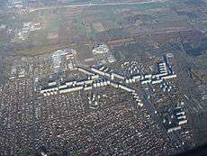
In 1969 a new panel housing estate was founded on the northeastern border of Budapest, in a wheat field and a former cemetery, near the Szilas-patak (Szilas Brook), commemorating the 50th anniversary of the Hungarian Soviet Republic (1919).[1] It was named Újpalota (literally means "Newcastle") after the adjacent village of Palota (means "Castle"), which initially became a suburb of the Hungarian capital, later part of Greater Budapest.[1]
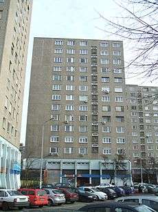
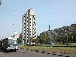
104 panel buildings (5, 7, 11, 13 and 15-storey blocks) were planned to the area, including 14,105 flats with an average floor space of 52.6 m² (including one, two, three and four-bedroom apartements).[2] According to Tibor Tenke, the architect of the housing estate, the original plan was modified, increasing the number of flats to 15,560.[1] The buildings were built by the BHK III. (3rd Housing Factory of Budapest, used Soviet-Hungarian technology),[3] that finished the construction in 1978.[1]
Demographics
In the late-1970s Újpalota had 60,000 inhabitants from all over the country, but mostly from the poor neighbourhoods of Budapest (Józsefváros, Kőbánya, Újpest, Kispest, Angyalföld), where their run-down houses were demolished.[1] Újpalota provided these poor families with a real improvement in living conditions, including district heating, piped hot water and flush toilets.[1] According to a 1975 survey, 70% of the householders were considered to be "worker", and only 12% passed the maturity exam (érettségi vizsga in Hungarian, a complex exam at the end of high school in Hungary).[1] 21% of the pairs raised 1 child, 46% two children and 19% three children.[1]
According to the 2011 census, Újpalota had only 33,557 inhabitants,[4] a significant decrease since the late-1970s.
See also
References
- 1 2 3 4 5 6 7 8 9 Tamás Lipp: Honfoglalás Újpalotán, Kossuth Könyvkiadó, Budapest, 1978, p. 142, pp. 5-14, ISBN 963-09-1131-0
- ↑ Budapest XV. kerület Újpalota építési, kapcsolódó és járulékos munkáinak módosított beruházási programja, Típustervező Intézet, Budapest, 1968, p. 225, pp. 200
- ↑ Dr. Jenő Gilyén: Panelos épületek szerkezetei, Tervezés méretezés, Műszaki Könyvkiadó. Budapest, 1982, pp. 21-25, 158-170, ISBN 963-10-4235-9
- ↑ Gazetteer of Hungary / Budapest
External links
Coordinates: 47°32′36.68″N 19°8′23.9″E / 47.5435222°N 19.139972°E