Üçayak Byzantine Church
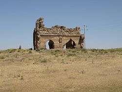
The ruins of the Üçayak Byzantine Church (Turkish: Üçayak Kilisesi (Three-legged Church)) are found in Kırşehir Province in Central Anatolia, Turkey. The church is unique in several respects. It is built on a remote location, apparently in a completely isolated, uninhabited area.[1]
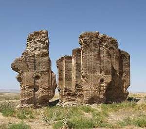
Its architectural design has been described as executed on an "exceptionally high artistic level". Other unusual features include a double church design, an all-brick construction, with the exception of its foundations, and sloping walls. It is dated to around late 10th to 11th centuries.[1] The style of the church is double-nave basilica.[2]
It is located in the southern part of Kırşehir Province, near the village of Taburoğlu, which is approximately six kilometres from the Yerköy-Yozgat highway.[2][3]
History
.jpg)
The Byzantine name of the location of the church is unknown. Proposed names include Justinianopolis, Pteria, and Mokissos. Near the church, there is a water spring but the absence of any human artefacts in the vicinity indicates that the church was built on a completely isolated and uninhabited area.[1]
The remnants of the decorations of the facades, its sloping walls, and its architectural style led to its chronology being placed to late 10th or 11th centuries AD.[1] The first report on the church was in 1842 by W. F. Ainsworth. His travel notes on the church were used by J.W. Crowfoot who visited the ruins in 1900, and were eventually published by Strzygowski in 1903. In 1938, an earthquake caused the dome arches of the church to collapse.[1]
Architecture
The construction of the church, solely using bricks as the medium, is very unusual in Byzantine architecture. The church foundation was made of stone. In 1900, J.W. Crowfoot reports a pinkish external layer covering the brick walls. In-between the walls, base material, consisting of rubble, stones and other fillers, was used. The filler material was supported by a wooden-beam structure.[1]
Double domes
The church design is very unusual for Byzantine architecture. The church is constructed as a double-church featuring two naves adjacent to each other and separated by a wall. The naves were quadrangular and each featured a separate dome.[1]
The double-church design is even more unusual because the two churches were constructed at the same time time, as opposed to being built sequentially, which was the construction method employed more often for churches of this type. Scholars speculate that the double church was constructed either in honour of two distinct saints or martyrs, or because a Byzantine emperor and his wife built it; the latter explanation being more probable, since no crypts or other artefacts, attesting to the worship of saints or martyrs, have been found.[1]
Restoration
The church is a rare example of early Byzantine period architecture in Kırşehir Province, which is considered to be located within the area occupied by ancient Cappadocia,[4] or at the border of the Byzantine provinces of Galatia and Cappadocia.[5] Ahi Evran University is planning restoration and conservation of the ruins.[4]
References
| Wikimedia Commons has media related to Üçayak. |
- 1 2 3 4 5 6 7 8 Toivanen Hanna-Riitta (2001). "Byzantine Church at Üçayak (Kirşehir, Cappadocia)". Encyclopaedia of the Hellenic World, Asia Minor.
Close to the ruined church there was a spring of water, but no material remains have been found, which means, that this church was built originally in a completely isolated and remote place.
- 1 2 J. Eric Cooper; Michael Decker (24 July 2012). Life and Society in Byzantine Cappadocia. Palgrave Macmillan. p. 151. ISBN 978-0-230-36106-5.
- ↑ "Üçayak Kilisesi". kirsehirkulturturizm.gov.tr.
- 1 2 "Üç Ayak Kilisesi İçin Çalışmalar Başladı". arkeolojihaber.net.
- ↑ Mihaljević, Marina (2014). "Üçayak: a forgotten Byzantine church". Byzantinische Zeitschrift. 2 (107): 735–754, pl. I–V.
Coordinates: 39°24′46″N 34°10′15″E / 39.41278°N 34.17083°E