Şişli
| Şişli-İstanbul | |
|---|---|
| District | |
|
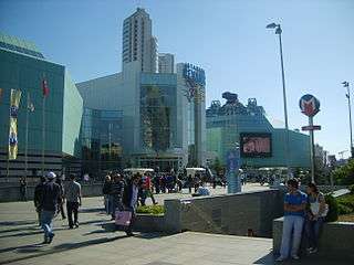
Entrance to the Şişli station of the Istanbul Metro in front of Istanbul Cevahir, Europe's largest shopping mall. | |
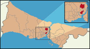 Location of Şişli in Istanbul | |
 Şişli-İstanbul Location of Şişli in Istanbul | |
| Coordinates: 41°03′37″N 28°59′16″E / 41.06028°N 28.98778°ECoordinates: 41°03′37″N 28°59′16″E / 41.06028°N 28.98778°E[1] | |
| Country | Turkey |
| Province | Istanbul Province |
| Government[1] | |
| • Mayor | Hayri İnönü (CHP) |
| • Governor | Mehmet Öklü |
| Area[2] | |
| • District | 35.01 km2 (13.52 sq mi) |
| Highest elevation[3] | 140 m (460 ft) |
| Lowest elevation[3] | 70 m (230 ft) |
| Population (2012)[4] | |
| • District | 318,217 |
| • District density | 9,100/km2 (24,000/sq mi) |
| Time zone | EET (UTC+2) |
| • Summer (DST) | EEST (UTC+3) |
| Postal code | 34360, 34371, 34373, 34375, 34377, 34379, 34380, 34382, 34394, 34396 |
| Area code(s) | 0-212 |
| Website |
www |
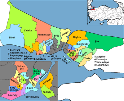
Şişli (pronounced [ˈʃiʃli]) is one of 39 districts of Istanbul, Turkey. Located on the European side of the city, it is bordered by Beşiktaş to the east, Sarıyer to the north, Eyüp and Kağıthane to the west, and Beyoğlu to the south. In 2009, Şişli had a population of 316,058.[5]
History
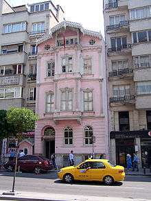
Until the 1800s, Şişli was open countryside, used for hunting and agriculture and leisure. It was developed as a middle class residential district during the last years of the Ottoman Empire and the early years of the Turkish Republic (the late 19th-early 20th centuries). French culture had a great influence in this period and the big avenues of Şişli had a European look; big stone buildings with high ceilings and art nouveau wrought-iron balconies, little elevators on wires in the middle of the stairway and so on. This trading middle-class was composed of Jews, Greeks and Armenians as well as Turks, many built homes in Şişli after a large fire in the district of Beyoğlu in 1870. Still today many families of Istanbul's local Armenian community live in the Kurtuluş neighbourhood of Şişli. The area was also popular with the Levantine trading families of this period who settled for trade or were contracted by the Ottoman Empire. Şişli attracted migrants from the former lands in Greece and the Balkans. In the late 19th century Şişli was one of the first areas supplied with tramlines, electricity and a gas supply. The orphanage of Darülaceze and the large Şişli Etfal Hospital were built here in this period, as well as the French schools of St. Michel and Notre Dame de Sion.
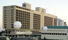
Following the founding of the Turkish Republic in the 1920s, larger and larger buildings were put up along wide avenues such as Halaskargazi Caddesi, the main road that runs through the middle of Şişli, with its little arcades of shops below tall buildings of apartments and offices. In the republic the area was still the residence of the middle-class, as well as traders there were now writers and poets and Şişli acquired theatres, cafes and other cultural amenities. The Hilton Istanbul Bosphorus was built here in the 1950s and many others followed.
From the 1950s onwards people from Anatolia began to migrate to Istanbul in search of work. In most cases they illegally built themselves squatters on unclaimed or government-owned land (see gecekondu). Some of these people settled in parts of Şişli in the 1950s and 1960s, especially at the northern sections of the district, around Mecidiyeköy.
The centre of Şişli today
Now that the wealthy elite of central Şişli have moved further out of the city, the large buildings on the grand avenues are occupied by offices, banks, and big shops. Since the 1970s most older buildings have been pulled down and replaced with newer, and perhaps less remarkable, multistory structures. The back streets are still residential, and many working-class families and students have settled here. As in most parts of Istanbul, the number of people living and working in these blocks challenges the existing infrastructure; for example, competition for parking spaces is intense, and traffic during peak hours can come to a standstill. But for the residents of Şişli, there are plenty of shops, cafés, pubs, and other amenities and these make life in Şişli pleasant. Additionally, Şişli's central location to other important areas of Istanbul adds to its desirability.
Business and shopping
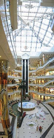
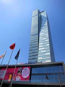
Being a central area well-served with public-transport and other infrastructure, Şişli is a center of trade and shopping. The main road through Şişli up to the skyscrapers of Mecidiyeköy, Gayrettepe, Levent and beyond is now lined with office blocks. Europe's largest and the world's second largest (urban-area) shopping mall, Cevahir İstanbul, is situated here. Due to Şişli's middle-class past and the enduring quality of some neighbourhoods the area is home to many upmarket shops mainly in the stylish and charming Nişantaşı area. Parking is an enduring problem, especially in the narrow side-streets.
People also come to Şişli for schooling; this city-centre area has some well-known high schools and a great number of dersane (preparatory courses for the annual university entrance exams), evening and weekend schools where people come to cram for university or high school entrance examinations, or to learn English.
There are many well-established cafes and restaurants, including fast-food for the students and shoppers.
Neighbourhoods
- Esentepe - home to the Municipality of Şişli and Zincirlikuyu Cemetery. Neighboring Gayrettepe and Levent neighborhoods of Beşiktaş district and Mecidiyeköy neighborhood, Esentepe also covers the west side of Büyükdere Street at Levent, where most of the plazas are located.
- Kurtuluş – known as Tatavla (Greek: Ταταύλα, "horse stable") in the Ottoman period, was home to a Greek and later Armenian community. The district had mostly wooden houses until 207 houses went up in flames in a huge fire on April 13, 1929. After the fire, it was rebuilt in narrow stone streets and, over time, concrete buildings, lined with cafés, patisseries, and shops. This cosmopolitan district has a long history, and has been home to many singers, artists, and actors. There are a small number of attractive old apartment buildings, but most of those built since the 1960s are ugly and crammed together. It was also known mainly for its traditional carnival, which was organized every year before Lent. The peak of the carnival, on the last day of Lent, took place in Kurtuluş and was known as Baklahorani.[6] After the riots of 1955, the Greek community left the area; however, their churches are open on religious holidays. Recently the district, like many other historic neighbourhoods in Istanbul, is being revitalized with mass restoration projects, in which historic buildings are repaired and painted, while the "modern" (characterless) concrete façades are restyled to look more in line with historic architectural characteristics.
- Teşvikiye – uphill from Beşiktaş, an old-established smart area with many classic European-style buildings as well as a busy high-class shopping district, Teşvikiye is one of the most attractive residential neighbourhoods in Istanbul. Since the 19th century, Teşvikiye has been home to many writers (including journalist Abdi Ipekçi, who was assassinated here in 1979), politicians and a great number of prominent business families and still holds a well-established middle-class, including some descendants of Levantine and Jewish families that built many of the beautiful stone apartment buildings of Teşvikiye in the Ottoman period. Prominent buildings include the Milli Reasürans building (this one does not have an ornate 19th century stonework façade but is one of Istanbul's best examples of modernism) and the ornate neo-Baroque Teşvikiye Mosque, built by Sultan Abdulhamid II, who established the neighbourhood by building this mosque and the nearby historic Teşvikiye Police Station, encouraging citizens of Istanbul to settle in this new district (hence the name Teşvikiye, which means encouragement in Turkish.) Among the shops of Teşvikiye lies Gerekli Şeyler, Turkey's specialist importer of fantasy and gaming publications including Star Wars, Marvel Comics and Wizards of the Coast. Pretty, narrow streets of 19th and early-20th century buildings housing expensive boutiques, parfumeries, art galleries and cafés. Some of these buildings are architectural masterpieces; one of them, the historic Maçka Palas, houses Istanbul's Gucci and Armani stores as well as Armani Café. Nişantaşı also has many stylish pubs and restaurants. Abdi İpekçi Avenue, Turkey's most expensive street in terms of lease prices, is located here. There are a number of well-known schools here too, including some buildings of Marmara University and Işık Lisesi. Parking is a problem.
- Nişantaşı – neighbourhood encompassing Teşvikiye, famous for its many Art Nouveau apartment buildings. The American Hospital, one of the city's best hospitals, is also located here.
- Mecidiyeköy – Business and shopping district north of Şişli; Istanbul's main market for computer equipment. Narrow streets of tall office buildings. A major intersection and bus terminal underneath a huge flyover, very noisy. Home of Galatasaray football club's Ali Sami Yen Stadium. The Profilo Shopping Center, cinema and bowling alley is here, its food court a popular eatery in the area. Mecidiyeköy Antikacılar Çarşısı (Mecidiyeköy Antiques Bazaar), a large multi-storey building with dozens of antiques shops (the largest of its kind in Istanbul) is located between Mecidiyeköy and Kuştepe.
- Okmeydanı – north of Şişli, home to some large hospitals. This was the archery practice ground of the Ottoman armies (which is the meaning of its name in Turkish), and an Ottoman mosque was built here. Later the land was planted with fruit trees, and in the 1960s turned over to developers for building as the city expanded. Darülaceze, the Ottoman-period orphanage, is here, built in 1896.
- Kuştepe – a gecekondu (illegally built) district of poor housing traditionally occupied by the Romani community and recent migrants from the countryside. In transformation since the Bilgi University opened a campus here.
- Pangaltı - home to Saint James Armenian Hospital and Cathedral of the Holy Spirit.
Politics
The mayor of Şişli is Hayri İnönü.
Places of interest
- Museums and historical places
- Sport venues
- Entertainment venues
- Religious buildings
- Şişli Mosque
- Teşvikiye Mosque
- Cathedral of the Holy Spirit
- Shopping malls
- Tall buildings
References
- 1 2 "İstanbul-İlçeler-Şişli" (in Turkish). İstanbul Net. Retrieved 2011-10-15.
- ↑ "Area of regions (including lakes), km²". Regional Statistics Database. Turkish Statistical Institute. 2002. Retrieved 2013-03-05.
- 1 2 "Nüfus Durumu" (in Turkish). Şişli Kaymakamlığı. Retrieved 2011-10-15.
- ↑ "Population of province/district centers and towns/villages by districts - 2012". Address Based Population Registration System (ABPRS) Database. Turkish Statistical Institute. Retrieved 2013-02-27.
- ↑ "2009 Census of Turkey". Turkish Statistical Institute. Retrieved 2010-03-11.
- ↑ Didem Danış, Ebru Kayaalp. "Elmadağ: A Neighborhood in Flux" (PDF). Institut français d'études anatoliennes Georges Dumézil. p. 19. Retrieved 16 December 2011.
External links
| Wikimedia Commons has media related to Şişli. |
- Şişli Municipality
- Official website of Mustafa Sarıgül, mayor of Şişli
- Atatürk Museum on Istanbul portal