's-Heer Arendskerke
| 's-Heer Arendskerke | ||
|---|---|---|
| ||
| Coordinates: 51°29′30″N 3°49′23″E / 51.49167°N 3.82306°E | ||
| Country | Netherlands | |
| Province | Zeeland | |
| Municipality | Goes | |
| Population (1 January 2009) | 1,347 | |

's-Heer Arendskerke is a small village of approximately 1300 inhabitants in the municipality of Goes in the south-western Netherlands.
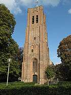
The settlement consists of two circles of houses around a Protestant church, on a single main road with an obsolete village hall. On the other side of the main road is a little industrial site called Eindewege (end of the road), containing tin huts and small garages. The remainder of the area is given over to fields for agriculture.
There is one primary school and one secondary school. There is also a GP and a nurse / physiotherapist.
The village also has a fire brigade unit with two trucks.
The Rijkswaterstaat maintains a winter depot here, with reserve stocks for dyke repairs.
There was once a railway station before the Second World War, but it was demolished in 1928.
's-Heer Arentskerke was a separate municipality until 1970.[1]
References
- ↑ Ad van der Meer and Onno Boonstra, Repertorium van Nederlandse gemeenten, KNAW, 2006.
External links
- J. Kuyper, Gemeente Atlas van Nederland, 1865-1870, "'s-Heer Arendskerke". Map of the former municipality, around 1868.
Coordinates: 51°29′27″N 3°49′20″E / 51.49083°N 3.82222°E
| Wikimedia Commons has media related to 's-Heer Arendskerke. |