1909 Wabash River earthquake
 | |
| Date | September 27, 1909 |
|---|---|
| Origin time | 04:45 local time |
| Magnitude | 5.1 Mfa [1] |
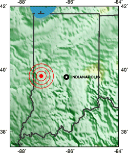
| Epicenter | 39°48′N 87°12′W / 39.8°N 87.2°WCoordinates: 39°48′N 87°12′W / 39.8°N 87.2°W [1] |
| Type | Unknown |
| Areas affected |
Indiana United States |
| Max. intensity | VII (Very strong) [1] |
| Casualties | None |
The 1909 Wabash River earthquake occurred at 04:45 local time on September 27 with a maximum Mercalli intensity of VII (Very strong). It measured 5.1 on a seismic scale that is based on an isoseismal map or the event's felt area. With moderate damage in the Wabash River Valley, it is currently the strongest earthquake recorded in the U.S. state of Indiana. The earthquake occurred somewhere along a fault within the Wabash Valley Seismic Zone.
Damage
The earthquake was felt over an area of 30,000 square miles.[2] In Terre Haute, the earthquake toppled two chimneys, cracked plaster, and knocked pictures from walls. Nearby Covington, north of Terre Haute in Fountain County, experienced several fallen chimneys and some broken windows. Chimneys were "jarred loose" in Princeton, Indiana, and one chimney was even "shaken to pieces" at Olivette, Missouri (a suburb of St. Louis). A brick wall was also "shook" down within St. Louis, Missouri. Reports came from various states, including Arkansas, Illinois, Iowa, Kentucky, Ohio, and Tennessee.[3]
See also
References
- 1 2 3 Stover, C. W.; Coffman, J. L. (1993), Seismicity of the United States, 1568–1989 (Revised) – U.S. Geological Survey Professional Paper 1527, United States Government Printing Office, pp. 3, 232
- ↑ "Indiana Earthquake History". USGS. 2008-07-16. Archived from the original on 8 December 2008. Retrieved 2008-11-15.
- ↑ "Historic Earthquakes: Wabash River Valley, near Terre Haute, Indiana". USGS. 2008-07-16. Retrieved 2008-11-15.
| Early history |    | |
|---|---|---|
| 1700–1799 | ||
| 1800–1816 | ||
| 1817–1899 |
| |
| 1900–1999 | ||
| Since 2000 | ||
| By topic |
| |
| By city and locale | ||
See also: History of the United States, History of the Midwestern United States and Portal:Indiana WikiProject Indiana's History Department | ||