1925 Santa Barbara earthquake
 Paso Robles Santa Ana | |
| Date | June 29, 1925 |
|---|---|
| Origin time | 14:44 UTC |
| Magnitude | 6.8 Mw [1][2] |
| Depth | Unknown |
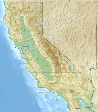
| Epicenter | 34°18′N 119°48′W / 34.3°N 119.8°WCoordinates: 34°18′N 119°48′W / 34.3°N 119.8°W [1] |
| Type | probably left-lateral reverse |
| Areas affected |
Central Coast (California) United States |
| Total damage | $8 million [3] |
| Max. intensity | IX (Violent) [1] |
| Casualties | 13 [3] |
The 1925 Santa Barbara earthquake hit the area of Santa Barbara, California on June 29, with a moment magnitude of 6.8 and a maximum Mercalli Intensity of IX (Violent). It resulted in 13 casualties and destroyed the historic center of the city, with damage estimated at $8 million.
Earthquake
Although no foreshocks were reported felt before the mainshock, a pressure gauge recording card at the local waterworks showed disturbances beginning at 3:27 a.m., which were likely caused by foreshocks.[4] At 6:44 a.m. the mainshock occurred which lasted 19 seconds.[5] The epicenter of the earthquake was located in the sea off the coast of Santa Barbara, in the Santa Barbara Channel.[3] The fault on which it occurred appears to have been an extension of the Mesa fault or the Santa Ynez system.[6] The earthquake was felt from Paso Robles (San Luis Obispo County) to the north to Santa Ana (Orange County) to the south and to Mojave (Kern County) to the east.
Damage
Major damage occurred in the city of Santa Barbara and along the coast, as well as north of Santa Ynez Mountains, including Santa Ynez and Santa Maria valleys.[3]
Though thirteen people died, it may have been far worse without the actions of three, later recognized heroes, who shut off the town gas and electricity preventing a possible catastrophic fire.[5] Most homes survived the earthquake in relatively good shape, although nearly every chimney in the city crumbled. The downtown of Santa Barbara was destroyed; only a few buildings along State Street, the main commercial street in the city, were still standing after the earthquake. The City Cab building and The Californian and Arlington garages, all large and fully occupied parking structures, collapsed full with cars of those traveling and on vacation. Many other vehicles were crushed in the downtown area, and at least one death resulted when a driver was caught at the wheel near the San Marcos building as walls of buildings fell onto the cars parked there.[7]
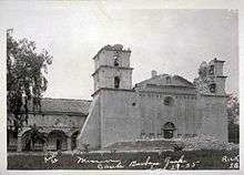
In the business district, an area of about 36 blocks, only a few structures were not substantially damaged, and many had to be completely demolished and rebuilt.[4] The facade of the church of the Mission Santa Barbara was severely damaged and lost its statues. Many important buildings, including hotels, offices, and the Potter Theater, were lost. The courthouse, jail, library, schools, and churches were among the buildings sustaining serious damage. Concrete curbs buckled in almost every block in Santa Barbara. Pavement on the boulevard along the beach was displaced by about 20–36 centimeters (0.66–1.18 ft), but the pavement in the downtown generally was not damaged.[3]
The earthen Sheffield Dam had been built close to the city in 1917. It was 720 feet (220 m) long and 25 feet (7.6 m) high and held 30 million US gallons (113,562,360 liters) of water. The soil under the dam liquefied during the earthquake and the dam collapsed, making it the only dam to fail during an earthquake in the United States until the Lower San Fernando Dam failed in 1971.[8] When it burst, a wall of rushing water swept between Voluntario and Alisos Streets taking with it trees, three houses, cars and flooding the lower part of town up to 2 feet (0.61 m) deep until it drained away.[9]
The Southern Pacific Company Railroad tracks were damaged in a number of places between Ventura and Gaviota, in particular, a portion between Naples and Santa Barbara was badly damaged and displaced.[3] Seaside bluffs fell into the ocean and a slight tsunami wave was noted by offshore ships. The town was completely cut off from telephone and telegraph, news from the outside world arrived by shortwave radio. The absence of post earthquake fire permitted scientists and geologists to study earthquake damage on various types of construction.[5]
The American Legion and the Naval Reserves from the Naval Reserve Center Santa Barbara helped to provide order amidst the chaos and manned posts and provided patrols throughout the town to inhibit looting of the damaged businesses and homes. Additional fire and police personnel arrived from as far as Los Angeles to assist the sailors and soldiers in keeping the order.[7]
Aftershocks
Three strong aftershocks occurred in the next few hours, though none causing any additional damage, with events occurring at 8:08, 10:45, and 10:57 am, and many smaller shocks continued throughout the day. An aftershock on July 3 caused additional cracked walls and damaged chimneys.[3][7]
Aftermath
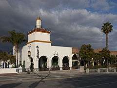
Since the downtown of Santa Barbara suffered irreparable damage, there was a large-scale construction effort in 1925 and 1926 aimed at removing or repairing damaged structures and constructing new buildings. This development completely altered the character of the city center. Before the earthquake, a considerable part of the center was built in the Moorish Revival style. After the earthquake, the decision was made to rebuild it in the Spanish Colonial Revival style. This effort was undertaken by the Santa Barbara Community Arts Association, which was founded in the beginning of the 1920s and viewed the earthquake as the opportunity to rebuild the city center in the unified architecture style.[10]
Many architects were invited to design the building facades, among them James Osborne Craig, George Washington Smith, Carleton Winslow, Bertram Goodhue, and Winsor Soule. Lionel Pries spent a year in Santa Barbara. As a result, many buildings later listed on National Register of Historic Places were designed in the late 1920s, among them the Santa Barbara County Courthouse and the front of the Andalucia Building.[10]
See also
- List of earthquakes in 1925
- List of earthquakes in California
- List of earthquakes in the United States
References
- 1 2 3 Stover & Coffman 1993, p. 77
- ↑ ISC (2014), ISC-GEM Global Instrumental Earthquake Catalogue (1900–2009), Version 1.05, International Seismological Centre
- 1 2 3 4 5 6 7 Stover & Coffman 1993, pp. 125, 126
- 1 2 "Significant Earthquakes and Faults, Santa Barbara Earthquake". Southern California Earthquake Data Center. Retrieved September 28, 2014.
- 1 2 3 Graffy, Neal (June 27, 2010). "1925 Earthquake – Day 1, Part 1". edhat.com.
- ↑ "California Earthquake History". U.S. Geological Survey Southern. Retrieved October 1, 2014.
- 1 2 3 Albert F. Nathan (June 30, 1925), "Southland Unites in Dispatching Relief to Earthquake victims by Train and Auto", Los Angeles Times
- ↑ http://www.usbr.gov/ssle/damsafety/Risk/BestPractices/27-SeismicEmbankmentPP20121121.pdf
- ↑ Lindley, Grant; Sylvester, Arthur Gibbs (February 21, 2006). "The 1925 Santa Barbara Earthquake: The Dam Break". Santa Barbara Earthquake History. UC Santa Barbara. Retrieved April 14, 2012.
- 1 2 "Andalucia Building" (PDF). National Park Service. Retrieved April 14, 2012.
Sources
- Stover, C.W.; Coffman, J.L. (1993), Seismicity of the United States, 1568–1989 (Revised), U.S. Geological Survey professional paper 1527, United States Government Printing Office
- Willis, Bailey (1925), "A Study Of The Santa Barbara Earthquake Of June 29, 1925" (PDF), Bulletin of the Seismological Society of America, Seismological Society of America, 15 (4): 255–278
External links
- 1925 Earthquake Historic Santa Barbara Courthouse photo gallery
- 1925 Santa Barbara Earthquake Survivor interview
- Santa Barbara Earthquake History
- Santa Barbara Earthquake History – photo gallery
- Vernon Dalhart and the Santa Barbara Earthquake of 1925
- Views of Earthquake Damage in Santa Barbara, California 1925, finding aid and online photo collection, Bancroft Library, University of California, Berkeley
- Historic earthquakes – United States Geological Survey
- M6.8 - Santa Barbara Channel, California – United States Geological Survey