1937 Atlantic hurricane season
| |
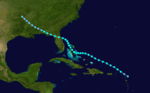
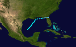
| Season summary map |
| First system formed |
July 29, 1937 |
| Last system dissipated |
October 21, 1937 |
| Strongest storm1 |
Six – 951 mbar (hPa) (28.08 inHg), 125 mph (205 km/h) |
| Total depressions |
16 |
| Total storms |
11 |
| Hurricanes |
4 |
| Major hurricanes (Cat. 3+) |
1 |
| Total fatalities |
Unknown |
| Total damage |
Unknown |
| 1Strongest storm is determined by lowest pressure |
Atlantic hurricane seasons
1935, 1936, 1937, 1938, 1939 |
The 1937 Atlantic hurricane season officially began on June 16, 1937, and lasted until October 31, 1937.[1] These dates conventionally delimit the period of each year when most tropical cyclones form in the Atlantic basin.
The 1937 season was not a very active one, with only four hurricanes and one major hurricane forming during the season and those stayed out to sea. Most of the activity during the 1937 season consisted of tropical storms. Ironically, Nova Scotia saw more tropical cyclone activity than the entire East Coast of the United States and the Gulf Coast of the United States. A tropical storm hit Tampa, Florida, and then grazed Nova Scotia. Tropical storms also hit Daytona Beach, Louisiana, southern Nova Scotia, and rural northwest Florida.
The most notable storm of the season actually was not tropical, at the time it made itself notable at least. The extratropical remnant of a hurricane struck just north of Halifax, Nova Scotia. The storm was moving swiftly, so most of the damage was strictly wind related.
Storms
Tropical Storm One
| Tropical storm (SSHWS) |
|
|
| Duration |
July 29 – August 1 |
| Peak intensity |
70 mph (110 km/h) (1-min) 996 mbar (hPa) |
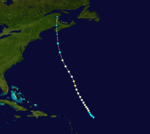
The first storm of the season affected the entire east coast of the United States and parts of maritime Canada. It formed in the Gulf of Mexico in late July and made landfall just north of St. Petersburg, Florida, where gale force winds were reported accompanied by heavy rainfall of up to eight and a half inches. Passing to the northeast, the storm followed the coast, brushing Cape Hatteras on the last day of July, reaching its peak intensity of 70 mph (110 km/h) shortly thereafter, in fact, it may have briefly intensified into a Category 1 hurricane during that time as it transitioned into a post-tropical cyclone. Banking out more to the east after transitioning, the storm passed well away from Cape Cod, turning northward late on August 1 and making landfall in southern Nova Scotia as a weaker system, similar in intensity to when it hit Florida. The storm dissipated over New Brunswick. Minor flooding and crop damage was reported in Florida, but no damage report exists from Nova Scotia.
Tropical Depression
| Tropical depression (SSHWS) |
|
|
| Duration |
August 1 – August 4 |
| Peak intensity |
25 mph (35 km/h) (1-min) |
Tropical Storm Two
| Tropical storm (SSHWS) |
|
|
| Duration |
August 2 – August 9 |
| Peak intensity |
65 mph (100 km/h) (1-min) 1005 mbar (hPa) |
Another east coast storm, this one formed in the southern Bahamas in early August as the first storm was dissipating. It was first noticed when the Bahamas reported gale force winds. The storm moved northward through the islands and passed 100 miles (160 km) or so east of Cape Hatteras, reaching its peak intensity of 65 mph (105 km/h) at about this time. Gently curving more northeastward, the storm passed about the same distance from Cape Cod. After passing not far south of Nova Scotia as a weakening system, the storm dissipated near Sable Island on August 9. No damage was reported.
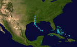
Tropical Storm Three
| Tropical storm (SSHWS) |
|
|
| Duration |
August 24 – September 2 |
| Peak intensity |
70 mph (110 km/h) (1-min) 995 mbar (hPa) |
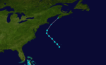
The season's third storm formed near the Leeward Islands on August 24 and headed northwest, turning westward into the Bahamas three days later, gradually strengthening as it did so. Shortly after grazing Andros Island, it turned sharply northward. The storm curved back to the northwest as it passed Cape Canaveral, reaching its peak intensity shortly before landfall at Daytona Beach, Florida near the threshold of hurricane intensity. The storm weakened slowly inland. It maintained a northwesterly course until dissipation on September 2 over central Arkansas. The storm, though small in size and relatively low in intensity, caused significant damage along its path. It killed 15 people when the steamship Tarpon sank in heavy seas off Panama City. The storm also felled many trees and power poles in Florida as well as causing minor damage to homes and businesses. Flooding washed out roads and bridges and stopped traffic in Florida's northwestern counties. Flooding in southern Alabama caused millions of dollars in crop damage and exceptionally high tides were reported along the coast of Georgia. No fatalities were reported, however.
Hurricane Four
| Category 2 hurricane (SSHWS) |
|
|
| Duration |
September 9 – September 14 |
| Peak intensity |
100 mph (155 km/h) (1-min) 992 mbar (hPa) |
The 1937 season's first definite hurricane was discovered about 200 miles (320 km) east of the Leeward Islands on September 9 when it was nearly at hurricane force. The hurricane headed northwest, slowly at first but then gaining speed on September 11 as it steadily strengthened. It reached its peak intensity of 100 mph (160 km/h), Category 2 on the Saffir Simpson Hurricane Scale, the next day. It passed roughly 100 miles (160 km) east-northeast of Bermuda while turning more northward. It weakened below hurricane status late on September 13 near Clark's Harbour, Nova Scotia, the next morning. It lost its identity over Chaleur Bay. No damage or casualties were reported although a British racing yacht, Endeavor I, did go missing for several days in gale conditions with 18 crew on board before it was sighted off Fastnet Rock with all hands safe.
Tropical Storm Five
| Tropical storm (SSHWS) |
|
|
| Duration |
September 10 – September 12 |
| Peak intensity |
70 mph (110 km/h) (1-min) 988 mbar (hPa) |
This short-lived storm was likely a subtropical storm but there was no satellite imagery to confirm its structure.
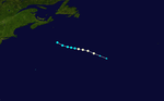
Hurricane Six
| Category 3 hurricane (SSHWS) |
|
|
| Duration |
September 13 – September 19 |
| Peak intensity |
125 mph (205 km/h) (1-min) 951 mbar (hPa) |
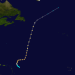
Storm Six was the strongest storm of the 1937 season. This storm was first discovered on September 14 at near-hurricane intensity about 200 miles (320 km) east of the Leeward Islands. The storm strengthened to a hurricane and turned north then east, continuing to intensify as it did so. The storm reached its peak intensity of 125 mph (201 km/h) on September 15 as it turned to the north-northeast. The storm maintained this track throughout most of the rest of its lifetime. On September 18 it curved more to the northeast and weakened. The storm became extratropical on September 19.
Tropical Storm Seven
| Tropical storm (SSHWS) |
|
|
| Duration |
September 16 – September 21 |
| Peak intensity |
60 mph (95 km/h) (1-min) 1002 mbar (hPa) |
Storm Seven developed in the Bay of Campeche on September 16 and curved northeastward through the central Gulf of Mexico. It was a weak system with winds never exceeding 45 mph (72 km/h), but it held that intensity for most of its lifetime. It grazed the Louisiana delta as it turned eastward, travelling along the northeastern Gulf Coast. The storm passed just south of Cape San Blas, Florida, and made landfall near Dekle Beach as a weakening system. It dissipated inland over Florida. Very little damage accompanied the system. Heavy rain fell in the Panhandle that washed over some roads, but no other damage was reported.
Hurricane Eight
| Category 2 hurricane (SSHWS) |
|
|
| Duration |
September 20 – September 26 |
| Peak intensity |
100 mph (155 km/h) (1-min) 982 mbar (hPa) |
The third hurricane of the season formed in the open Atlantic between Cape Verde and the Windward Islands, a place known as Hurricane Alley due to the large number of hurricanes that trace their origins there. It was discovered close to hurricane strength on September 20 and moved generally north-northwestward throughout its lifetime. It became a Category 2 hurricane on the night of September 22 and as far as is known, did not strengthen further. It continued to traverse north-northeast across the open ocean east of Bermuda, maintaining intensity. It became extratropical on the night of September 25, only then weakening to Category 1 intensity. The post-tropical system recurved to the northeast and struck Nova Scotia with sustained winds of 85 mph (137 km/h), crossing just north of Halifax and retained hurricane-force winds into Newfoundland. The storm finally lost its identity near the southern tip of Greenland. No damage reports exist but gale warnings were ordered as far west as New England.
Tropical Storm Nine
| Tropical storm (SSHWS) |
|
|
| Duration |
September 26 – September 28 |
| Peak intensity |
50 mph (85 km/h) (1-min) 1010 mbar (hPa) |
Storm Nine was first recognized southwest of Andros Island on September 26 near the north coast of Cuba. It passed through the northern Bahamas and headed on a north-northeasterly track across the western Atlantic. Its winds never rose above 45 mph (72 km/h) as a tropical cyclone and it became extratropical late on September 28 having caused little effects.
Tropical Storm Ten
| Tropical storm (SSHWS) |
|
|
| Duration |
October 2 – October 4 |
| Peak intensity |
45 mph (75 km/h) (1-min) 1002 mbar (hPa) |
The season continued with yet another weak system. It formed off the north coast of Honduras in early October and moved due north into the Gulf of Mexico, not gaining any intensity as it interacted with another low pressure system (possibly a separate tropical depression). It turned to the northwest soon after passing the western tip of Cuba and moved across the central Gulf. It then turned northward on October 3, making landfall in Louisiana near New Iberia with 40 mph (64 km/h) winds. No effects from this system were reported.
Hurricane Eleven
| Category 1 hurricane (SSHWS) |
|
|
| Duration |
October 19 – October 21 |
| Peak intensity |
80 mph (130 km/h) (1-min) 995 mbar (hPa) |
See also
References
External links
|
|---|
|
| |
|
-
 Book Book
-
 Category Category
-
 Portal Portal
-
 WikiProject WikiProject
-
 Commons Commons
|