1940 New Hampshire earthquakes
  | |
| Date | 20 December 1940 |
|---|---|
| Origin time | 7:27 UTC [1] |
| Magnitude | 5.3 Mw [1] |
| Depth | 10 km (6.2 mi) [1] |
| Epicenter | 43°50′N 71°17′W / 43.83°N 71.28°W [1] |
| Type | Unknown |
| Areas affected |
New England United States |
| Max. intensity | VII (Very strong) [1] |
| Aftershocks | 5.6 Mw Dec 24 at 13:43 [1] |
The 1940 New Hampshire earthquakes struck on December 20 and again on December 24. The initial shock measured 5.3 and the second shock measured 5.6 on the moment magnitude scale. With a maximum Mercalli intensity of VII (Very strong), these doublet earthquakes were the largest to hit the state. Damage included minor fractures or knocked over chimneys in a zone extending through New Hampshire and four other states: Maine, New York, Vermont and Massachusetts.
History
While not known for earthquakes, New Hampshire has been dotted with both major and minor events. The first recorded significant event to strike the state was the 1663 Charlevoix earthquake, originating in the Saint Lawrence River fault zone. The extent of the earthquake is not firm, at least in the state, as the population was composed largely of colonial settlers who had left the east coast. The 1663 earthquake felled chimneys, oscillated houses, and threw pewter from shelves in the Massachusetts Bay area.[2]
Geography
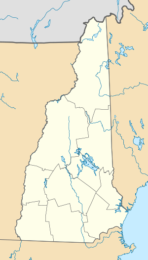
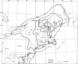
Reports of the 1940 earthquake extended as far north as Montreal and Quebec in Canada, and included Maine, New York, New Jersey, Pennsylvania, northeastern Delaware, Massachusetts, Vermont and Rhode Island.[3] The epicenter was next to the Ossipee Mountains, near the town of Ossipee, New Hampshire. These mountains are the remains of an ancient volcanic ring dike.[4] A similar ring dike can be seen in southern New Hampshire at Pawtuckaway State Park.
Damage
With a Richter magnitude of 5.5 and a Mercalli intensity of VII, the earthquake spawned waves of minor damage around its epicenter. There were reports of fractured pipes, walls, and furniture, as well as "fallen plaster" near the epicenter.[3] The number of chimneys damaged totaled 20, in addition to fallen ones. The earthquake caused damage to wells, turning the water brown[3] and displayed strength by movement, causing five monuments to shift from their original position at a cemetery, and moving one old house in the village of Wonalancet roughly 12 inches (30 cm). The earthquake additionally shifted objects as heavy as stoves. Aftershocks of the earthquake occurred over the next several months.[3]
See also
References
- 1 2 3 4 5 6 Stover, C. W.; Coffman, J. L. (1993), Seismicity of the United States, 1568–1989 (Revised), U.S. Geological Survey Professional Paper 1527, United States Government Printing Office, p. 302
- ↑ "New Hampshire - Earthquake History". United States Geological Survey. October 21, 2009. Retrieved December 24, 2009.
- 1 2 3 4 "Historic Earthquakes". United States Geological Survey. October 21, 2009. Retrieved December 20, 2009.
- ↑ Hall, Anthony, Igneous Petrology, Longman, 1987 p.75–76 ISBN 0-582-30174-2
Sources
- Billings, M. P. (1942), "Geology of the Central Area of the Ossipee Mountains, New Hampshire, earthquakes", Bulletin of the Seismological Society of America, Seismological Society of America, 32 (2): 83–92
- Devlin, J. J.; Langguth, L. C.; Arringdale, R. L. (1942), "Macroseismic study of the New Hampshire earthquakes of December 1940", Bulletin of the Seismological Society of America, Seismological Society of America, 32 (2): 67–73
- Don Leet, L.; Linehan D. (1942), "Instrumental study of the New Hampshire earthquakes of December, 1940", Bulletin of the Seismological Society of America, Seismological Society of America, 32 (2): 75–82