1977 Pacific hurricane season
| |
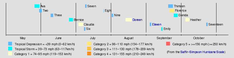
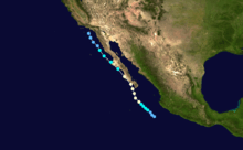
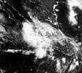
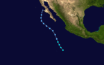
| Season summary map |
| First system formed |
May 26, 1977 |
| Last system dissipated |
October 23, 1977 |
| Strongest storm1 |
Florence – 105 mph (165 km/h) (1-minute sustained) |
| Total depressions |
17 |
| Total storms |
8 (record low, tied with 2010) |
| Hurricanes |
4 |
| Major hurricanes (Cat. 3+) |
0 (record low, tied with 2003) |
| Total fatalities |
Unknown |
| Total damage |
$25 million (1977 USD) |
| 1Strongest storm is determined by lowest pressure |
Pacific hurricane seasons
1975, 1976, 1977, 1978, 1979 |
The 1977 Pacific hurricane season was, at the time, the least active in recorded history. Only eight tropical storms formed, and four hurricanes; they would be tied and surpassed, respectively, by the 2010 Pacific hurricane season. There were no major hurricanes; the next time this happened would be the 2003 season. In addition, there was just one storm in each of May, June, July, August, and October, which is also low; the other three storms were in September. Activity in the central Pacific was zero, as no storms formed there nor moved in from the east.
The low seasonal activity also occurred in the Atlantic hurricane season and in the typhoon season of the western Pacific. This was a worldwide trend; various factors inhibited tropical cyclone development throughout the northern hemisphere, resulting in a record low level of tropical cyclones worldwide. Hurricane Anita of the 1977 Atlantic hurricane season crossed into the basin however it was not renamed because it did not reach tropical storm status while in the basin.
Seasonal summary
The 1977 Pacific hurricane season had the lowest number of tropical storms since reliable records began in 1949,[1] producing 17 tropical depressions, 8 of which became tropical storms or hurricanes.[1] The season officially started on May 15, 1977 in the Eastern Pacific Ocean, the area east of 140°W and on June 1 in the Central Pacific which is between the International Date Line and 140°W, and lasted until November 30, 1977 in both areas.
The first storm of the season, Tropical Storm Ava, formed off the southwest coast of Mexico on May 26. Between June and August, three named storms formed, with one forming in each month. September was the most active month, producing three named storm storms. One of those storms was Hurricane Florence, the strongest of the season. Tropical Depression Seventeen, the last storm of the year, dissipated on October 23. This season was the last to use the old naming lists that only had female names. Starting in the 1978 season, the naming lists began to include male names.[2]
Storms
Tropical Storm Ava
| Tropical storm (SSHWS) |
|
|
| Duration |
May 26 – May 30 |
| Peak intensity |
65 mph (100 km/h) (1-min) 997 mbar (hPa) |
Tropical Storm Ava formed on May 26 about 600 miles (965 km) southwest of Manzanillo. It moved northward, quickly intensifying into a tropical storm. At its peak intensity it had winds of 65 mph (101 km/h) and lowest pressure of 997mb. It weakened to a tropical depression on May 29 and dissipated on May 30 about 390 miles (630 km) west of Manzanillo.[3]
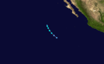
Tropical Depression Two
| Tropical depression (SSHWS) |
|
|
| Duration |
May 30 – June 1 |
| Peak intensity |
35 mph (55 km/h) (1-min) |
This depression formed 70 miles (110 km) southwest of the Honduras–Nicaragua border. On June 1 it dissipated just off the El Salvador coast.[4]
Tropical Depression Three
| Tropical depression (SSHWS) |
|
|
| Duration |
June 9 – June 11 |
| Peak intensity |
35 mph (55 km/h) (1-min) |
Tropical Depression Three formed 350 miles (565 km) west of the Honduras–Nicaragua border on June 9. Two days later it dissipated in almost the same location.[4]
Tropical Storm Bernice
| Tropical storm (SSHWS) |
|
|
| Duration |
June 25 – June 28 |
| Peak intensity |
40 mph (65 km/h) (1-min) |
Tropical Storm Bernice formed on June 25 about 555 miles (895 km) southeast of Acapulco. It moved northwestward and strengthened to a tropical storm on June 26. At its peak intensity it had winds of 40 mph (64 km/h). It continued moving north-west and dissipated on June 28 about 890 miles (1430 km) west of Cabo San Lucas, Mexico.[3]
Hurricane Claudia
| Category 1 hurricane (SSHWS) |
|
|
| Duration |
July 3 – July 7 |
| Peak intensity |
90 mph (150 km/h) (1-min) |
Hurricane Claudia formed on July 3 about 580 miles (935 km) south of Cabo San Lucas, Mexico. It moved westward, quickly intensifying into a tropical storm and becoming a hurricane on July 4. At its peak intensity it had winds of 90 mph (148 km/h). It continued moving westward, weakening to a tropical storm on July 5 before dissipating on July 7.
Tropical Depression Six
| Tropical depression (SSHWS) |
|
|
| Duration |
July 8 – July 9 |
| Peak intensity |
35 mph (55 km/h) (1-min) |
This depression existed from July 8 until July 9 off the southwest coast of the Baja California peninsula.[4]
Tropical Depression Seven
| Tropical depression (SSHWS) |
|
|
| Duration |
July 9 – July 10 |
| Peak intensity |
35 mph (55 km/h) (1-min) |
This depression existed from July 9 until July 10.[4]
Tropical Depression Eight
| Tropical depression (SSHWS) |
|
|
| Duration |
July 25 – July 25 |
| Peak intensity |
35 mph (55 km/h) (1-min) |
This depression existed on July 25.[4]
Tropical Depression Nine
| Tropical depression (SSHWS) |
|
|
| Duration |
August 1 – August 2 |
| Peak intensity |
35 mph (55 km/h) (1-min) |
This depression existed from August 1 until August 2.[4]
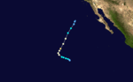
Hurricane Doreen
| Category 1 hurricane (SSHWS) |
|
|
| Duration |
August 13 – August 18 |
| Peak intensity |
75 mph (120 km/h) (1-min) 979 mbar (hPa) |
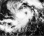
Hurricane Doreen formed on August 13 and moved northward. The next day it intensified into a hurricane. At its peak intensity it had winds of 75 mph (121 km/h) and lowest pressure of 979mb, making it the lowest measured pressure of the season. It paralleled Mexico, moving north. It brushed the extreme west of Mexico on August 16 and dissipated before reaching California on the August 18. The remnants of the hurricane did bring heavy rain to California, however. The highest amount reported was 7.45 inches at Mount San Jacinto in southern California.[5] In desert areas in the southwestern part of the state, rains destroyed 325 homes and businesses and caused the evacuation of several people. Parts of the recently repaired Interstate 8 were destroyed again, and two of the lanes of Interstate 15 between Barstow and Las Vegas were washed out. In San Diego and Imperial County, the total damage to agricultural interests was $25 million (1977 USD).
Tropical Depression Eleven (Anita)
| Tropical depression (SSHWS) |
|
|
| Duration |
September 3 – September 4 |
| Peak intensity |
35 mph (55 km/h) (1-min) |
On August 29, a tropical depression formed over the Gulf of Mexico and tracked slowly west. It quickly strengthened, reaching hurricane strength within 30 hours of formation. It eventually achieved Category 5 status before striking northern Mexico on September 2. The mountainous terrain of Mexico nearly caused Anita to dissipate;[6] however, its circulation survived the crossing and emerged over the Pacific on September 3 as a tropical depression. The system featured a 300 mi (485 km) wide area of convection and traveled west in response to a ridge over Baja California. The depression traversed Islas Marías and soon moved over cooler waters, prompting weakening. Lacking thermal support, the depression degenerated into a remnant low on September 3 off the southern tip of Baja California Sur.[4]
Tropical Storm Emily
| Tropical storm (SSHWS) |
|
|
| Duration |
September 13 – September 14 |
| Peak intensity |
40 mph (65 km/h) (1-min) |
Tropical Storm Emily formed on September 13 and moved northwestward. At its peak intensity it had winds of 40 mph (64 km/h). It continued moving north-west and dissipated on September 14 about 875 miles (1410 km) west of Cabo San Lucas, Mexico.
Tropical Depression Thirteen
| Tropical depression (SSHWS) |
|
|
| Duration |
September 19 – September 23 |
| Peak intensity |
35 mph (55 km/h) (1-min) |
This depression existed from September 19 until September 23.[4]
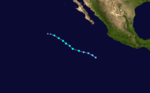
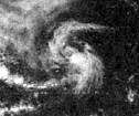
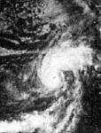
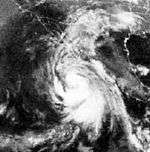
Hurricane Florence
| Category 2 hurricane (SSHWS) |
|
|
| Duration |
September 20 – September 24 |
| Peak intensity |
105 mph (165 km/h) (1-min) |
A tropical depression formed on September 20 and moved northward, intensifying into a tropical storm the next day. On September 22 it became Hurricane Florence. At its peak intensity of 105 mph (165 km/h), Florence became the strongest storm of the season. It turned moving northeast and dissipated on September 24. Its remnants brought rain to California.
Tropical Storm Glenda
| Tropical storm (SSHWS) |
|
|
| Duration |
September 24 – September 27 |
| Peak intensity |
45 mph (75 km/h) (1-min) |
Tropical Storm Glenda formed on September 24 and moved northwestward. At its peak intensity it had winds of 40 mph (64 km/h). It continued moving north-northwest and dissipated on the September 27.
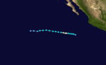
Hurricane Heather
| Category 1 hurricane (SSHWS) |
|
|
| Duration |
October 4 – October 7 |
| Peak intensity |
85 mph (140 km/h) (1-min) 984 mbar (hPa) |
A tropical depression formed on October 4 about 495 miles (800 km) west of Acapulco, Mexico. It quickly intensified into a tropical storm as it moved northwestward, and became Hurricane Heather on October 5. At its peak intensity it had winds of 85 mph (138 km/h). It turned moving north-northeast and dissipated on October 7. The remnants of Heather continued moving in that direction, and brought rain to Arizona. Up to 14 inches fell in the mountains of southeast Arizona.[7]
Tropical Depression Seventeen
This depression existed from October 22 until October 23 off the southwest coast of the Baja California peninsula.[4]
Storm names
This is the same list used in the 1973 season. This is also the last time that this list was used, as modern naming began in 1978. This is therefore the final Pacific hurricane season to have lists with only female names.
- Ava
- Bernice
- Claudia
- Doreen
- Emily
- Florence
- Glenda
|
- Heather
- Irah (unused)
- Jennifer (unused)
- Katherine (unused)
- Lillian (unused)
- Mora (unused)
- Natalie (unused)
|
- Odessa (unused)
- Prudence (unused)
- Roslyn (unused)
- Sylvia (unused)
- Tillie (unused)
- Victoria (unused)
- Wallie (unused)
|
The central Pacific used names and numbers from the western Pacific's typhoon list. No names were required.
See also
References
External links
|
|---|
|
| |
|
-
 Book Book
-
 Category Category
-
 Portal Portal
-
 WikiProject WikiProject
-
 Commons Commons
|