1979 Coyote Lake earthquake
 Reno Santa Rosa Gilroy Hollister San Luis Obispo | |
| Date | August 6, 1979 |
|---|---|
| Origin time | 17:05:24 UTC [1] |
| Magnitude | 5.7 MW [1] |
| Depth | 10 km (6.2 mi) [1] |
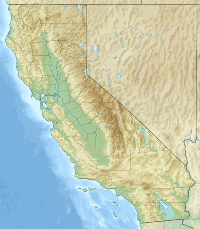
| Epicenter | 37°06′N 121°34′W / 37.1°N 121.56°WCoordinates: 37°06′N 121°34′W / 37.1°N 121.56°W [1] |
| Type | Strike-slip [2] |
| Areas affected |
South Bay Northern California United States |
| Total damage | $500,000 [3] |
| Max. intensity | VII (Very strong) [3] |
| Peak acceleration | .42g [4] |
| Casualties | 16 injured [3] |
The 1979 Coyote Lake earthquake occurred at 10:05:24 local time on August 6 with a moment magnitude of 5.7 and a maximum Mercalli Intensity of VII (Very strong). The shock occurred on the Calaveras Fault near Coyote Lake in Santa Clara County, California and resulted in a number of injuries, including some that required hospitalization. Most of the $500,000 in damage that was caused was non-structural, but several businesses were closed for repairs. Data from numerous strong motion instruments was used to determine the type, depth, and extent of slip. A mild aftershock sequence lasted throughout the remainder of the month that was of interest to seismologists, especially with regard to fault creep, and following the event, local governments evaluated their response to the incident.
Tectonic setting
Several strands of the San Andreas Fault System in the eastern region of the San Francisco Bay Area are the Hayward–Rodgers Creek and Calaveras Faults. The Hayward Fault exhibits fault creep, but it also has potential for large earthquakes, like the 1868 M7 Hayward earthquake that occurred on its southern segment. The northern Calaveras Fault meets the Hayward Fault near the Calaveras Reservoir and can also produce large earthquakes. Except for a ~M6.5 shock that occurred in 1911, the central and southern segments might only produce smaller events and fault creep.[5]
Earthquake
The earthquake originated (without foreshocks) on the Calaveras Fault near Coyote Lake in Santa Clara County. It was felt up to 120 mi (200 km) away (from Santa Rosa in the north to San Luis Obispo in the south) and made some high-rise buildings sway in Reno, Nevada, but damage was mainly limited to the nearby towns of Gilroy and Hollister. The earlier M7 Hayward earthquake occurred about 31 mi (50 km) to the north and the 1911 shock was located near Mount Hamilton.[6]
About fifty strong motion stations recorded the event, including an array of units along the rupture zone, and instruments at the Berkeley Seismological Laboratory (about 62 mi (100 km) away). The records revealed that strike-slip motion occurred over 8.7 mi (14 km) on a vertical fault, and that the total amount of slip varied with depth, with more slip occurring in the shallower regions. The two closest stations at Coyote Creek and Gilroy, as well as the Berkeley stations, were used to refine the overall fault length, slip, and depth of faulting.[2]
Strong motion
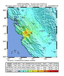
The event was captured on seismographs at distances of up to 71 miles (114 km), including Richmond, with the unit 56 ft (17 m) "down hole" in bay mud. Other underground instruments on the BART Transbay Tube, as well as the Richmond site, showed accelerations that were very low. In San Juan Bautista, the U.S. Route 101/State Route 156 overpass saw peak acceleration of .12g on the ground (with .29g on the structure). Instruments on the gymnasium roof diaphragm at the campus of West Valley College in Saratoga provided records of interest. Of a number of dams that had instruments installed, the San Luis Dam at San Luis Reservoir had the strongest response. The highest acceleration of .42g was seen at the Gilroy Array within the fault zone.[4]
Damage
In Gilroy and Hollister, sixteen people were injured, and damage totaled $500,000. Chimneys fell (especially on older homes in the downtown area of Gilroy) and glass was broken, but in Gilroy structural damage afflicted five buildings. A wall was cracked at city hall, and a court room ceiling collapsed. Damaged structural components at a Ford's Department Store forced its closure. In Hollister, a J. C. Penney had a hole and cracks in its ceiling and a parapet collapsed at a law office. At Casa de Fruta, a service station sustained structural damage, as did a fire station at Pacheco Pass.[3]
An early estimate by the Small Business Administration put total damage in Gilroy at twice the amount of what was seen in Hollister. Ten victims were brought to Hazel Hawkins Memorial Hospital in Hollister for treatment of lacerations, a cardiac problem, and anxiety. In Gilroy, the Wheeler Hospital saw six similar cases and a patient with a fractured hip. Most of those that sought care (including four that were transported by ambulance) were treated and released, but six were admitted.[7]
Aftershocks
The United States Geological Survey operated a network of seismograph stations in the region where the shock occurred since 1969. A survey of the aftershock activity used data from these stations, along with a custom crustal velocity model, to narrow epicenter locations to within several tens of meters. The study indicated that the mainshock and the aftershocks were aligned with the strike and dip of the Calaveras Fault in that area and were classified into three distinct groups. The east-dipping northeastern group, a diffuse middle group, and a shallow and nearly vertical southwestern group showed variations of slip, especially in the 18 months after the mainshock, when fault creep was significantly higher in the northeastern and middle groups.[8]
Response
While none of the affected counties or cities declared a state of emergency following the event, the Small Business Administration did approve a request by the Office of Emergency Services for a disaster declaration in late September. This formality paved the way for low interest loans for commercial or residential properties that suffered damage, but only about 50 claims were expected. Local authorities had trained for disasters on a regular basis, and the response to the light damage was considered smooth, though some officials sought room for improvement. Discussions followed the event, with local governments focusing on telecommunication problems, emergency power systems, and seismic safety.[7]
References
- 1 2 3 4 ISC (2015), ISC-GEM Global Instrumental Earthquake Catalogue (1900–2009), Version 2.0, International Seismological Centre
- 1 2 Bouchon, M. (1982), "The rupture mechanism of the Coyote Lake earthquake of 6 August 1979 inferred from near-field data", Bulletin of the Seismological Society of America, Seismological Society of America, 72 (3): 745, 748, 749, 756
- 1 2 3 4 Stover, C. W.; Coffman, J. L. (1993), Seismicity of the United States, 1568–1989 (Revised) – U.S. Geological Survey Professional Paper 1527, United States Government Printing Office, pp. 94, 165, 166
- 1 2 Porcella, R. L.; Matthiesen, R. B.; McJunkin, R. D.; Ragsdale, J. T. (1979), Compilation of strong-motion records recovered from the Coyote Lake earthquake of 6 August 1979 (PDF), Open File Report 79-385, California Division of Mines and Geology, pp. 4–10
- ↑ Yeats, R. (2012), Active Faults of the World, Cambridge University Press, pp. 92–94, ISBN 978-0-521-19085-5
- ↑ Uhrhammer, R. A. (1980), "Observations of the Coyotoe Lake, California earthquake sequence of August 6, 1979", Bulletin of the Seismological Society of America, Seismological Society of America, 70 (2): 559, 562
- 1 2 Stromberg, P. A.; Baird, B. P. (September 28, 1979), Staff report on the Hollister-Gilroy earthquake, August 6, 1979, California Seismic Safety Commission, pp. 3–8, 12–15
- ↑ Reasenberg, P.; Ellsworth, W. L. (1982), "Aftershocks of the Coyote Lake, California Earthquake of August 6, 1979: A detailed study", Journal of Geophysical Research, American Geophysical Union, 87 (B13): 10,637, 10,638, 10,641, 10,654, doi:10.1029/jb087ib13p10637