1992 Cairo earthquake
| Date | October 12, 1992 |
|---|---|
| Magnitude | 5.8 MB |
| Depth | 22 km (14 mi) |
| Epicenter | 29°46′41″N 31°08′38″E / 29.778°N 31.144°ECoordinates: 29°46′41″N 31°08′38″E / 29.778°N 31.144°E |
| Areas affected | Egypt, Cairo |
| Casualties | 7,057 |
The 1992 Cairo earthquake occurred at 15:09 local time (13:09 UTC) on 12 October, with an epicenter near Dahshur, 35 km (22 mi) south of Cairo. The earthquake had a magnitude of 5.8, but was unusually destructive for its size, causing 545 deaths, injuring 6,512 and making 50,000 people homeless. It was the most damaging seismic event to affect Cairo since 1847.[1]
Geology
Cairo is sited within a diffuse zone of faulting that transfers extension from the Gulf of Suez Rift to the Manzala rift beneath the Nile delta.[2]
Damage
The areas of greatest damage were in Old Cairo, Bulaq and southwards along the Nile as far as Gerza, on the west bank.[3] 350 buildings were completely destroyed and 9,000 other severely damaged. 216 mosques and 350 schools were badly damaged and about 50,000 people made homeless.[3] Most of the severe damage was confined to older masonry structures and particularly those built of adobe. Liquefaction was reported from areas near the epicenter.[1]
The high number of deaths and injuries (545 and 6,512 respectively) was partly due to the amount of panic caused by the earthquake in Cairo itself.[3] Damage was reported to have affected 212 out of a total of 560 historic monuments in the Cairo area.[4] A large block fell from the Great Pyramid of Giza.[3]
Earthquake characteristics
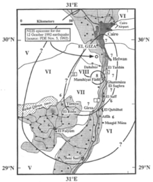
The earthquake was felt throughout most of northern Egypt, in Alexandria, Port Said and as far south as Asyut, and in southern Israel.[3] The calculated focal mechanism suggests that this event originated on a WNW-ESE or W-E trending normal fault with a small strike-slip component.[5] The aftershocks extended about 11 km (6.8 mi) to the southeast of the main shock epicenter, indicating unidirectional rupture propagation. The estimated fault rupture length was also 11 km (6.8 mi).[5] The earthquake consisted of two sub-events, the second located about 27 km (17 mi) southeast of the first.[6]
See also
References
- 1 2 Fergany, E.A.; Sawda S. (2009). "Estimation of Ground Motion at Damaged Area During 1992 Cairo Earthquake Using Empirical Green's Function". Seismological Research Letters. 80 (1): 81–88. doi:10.1785/gssrl.80.1.81. Retrieved 9 June 2010.
- ↑ Bosworth, W.; Huchon P. & McClay K.R. (2005). "The Red Sea and Gulf of Aden Basins" (PDF). Journal of African Earth Sciences. 43: 334–378. Bibcode:2005JAfES..43..334B. doi:10.1016/j.jafrearsci.2005.07.020. Retrieved 9 June 2010.
- 1 2 3 4 5 "NGDC page on the Cairo earthquake". Retrieved 9 June 2010.
- ↑ Sykora, D.; Look D.; Croci G.; Karaesman E. & Karaesmen E. (1993). "Reconnaissance Report of Damage to Historic Monuments in Cairo, Egypt Following the October 12, 1992 Dahshur Earthquake". Retrieved 9 June 2010.
- 1 2 Hussein, H.M. (1999). "Source process of the October 12, 1992 Cairo earthquake" (PDF). Annali di Geofisica. 42 (4): 665–674. Retrieved 9 June 2010.
- ↑ Hussein, H.M.; Korrat I.M. & Abdl Fattah A.K. (1996). "The October 12, 1992 Cairo earthquake a complex multiple shock". Bulletin of the International Institute of Seismology and Earthquake Engineering. 30: 9–21. Retrieved 9 June 2010.