2012 Visayas earthquake
| Date | February 6, 2012 |
|---|---|
| Origin time | 11:49:16 PST |
| Magnitude | 6.7 Mw |
| Depth | 11 km |
| Epicenter | 9°57′50″N 123°14′46″E / 9.964°N 123.246°ECoordinates: 9°57′50″N 123°14′46″E / 9.964°N 123.246°E |
| Areas affected | Philippines |
| Total damage | Structural collapse, landslides |
| Max. intensity | PEIS – VII (Destructive)[1] |
| Tsunami | Yes |
| Landslides | Yes |
| Aftershocks | 1600+ (as of February 7, 2012, 7:45 PST)[2] |
| Casualties |
51 dead[3][4] 112 injured 62 missing |
.svg.png)
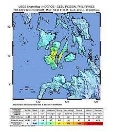
The 2012 Visayas earthquake occurred on February 6 at 11:49 PST with a moment magnitude of 6.7 and a maximum intensity of VII (Destructive) off the coast of Negros Oriental, Philippines. The epicenter of the undersea blind thrust earthquake was approximately 72 kilometres (45 mi) north of Dumaguete, Negros Oriental.[5][6][7]
Earthquake
Recorded intensities according to the PHIVOLCS Earthquake Intensity Scale (PEIS) were 7 in Dumaguete and V (PEIS) in Cebu.[8] The earthquake was felt as far as Mindanao in the provinces of Misamis and Lanao and as far as Iligan.[9]
Geology
The Philippines lies within the Pacific Ring of Fire, which causes the country to have frequent seismic and volcanic activity. In Cebu, the earthquake was the strongest so far of 2012. The strongest earthquake to hit Negros happened in 1948, but did not cause massive damage.[10]
According to PHIVOLCS, the earthquake was caused by movement on a previously undiscovered fault.[11] However, according to an Environmental Sciences professor, this fault was already known to private geologists hired by the Negros Occidental government to create a land use map for the province.[12]
Tsunami warning
The Philippine Institute of Volcanology and Seismology (PHIVOLCS) gave a level two tsunami alert, indicating that the public should be on watch for "unusual waves", but did not call for any evacuation. Despite this, in Cebu City, panic erupts and many residents fled towards higher ground due to rumors that a tsunami had hit the coastal villages of Ermita, Mambaling and Pasil. Residents of Dumaguete also scrambled to the mountain town of Valencia because of the scare. These rumors were later confirmed to be false. PHIVOLCS announced the tsunami alert at 14:30 PST.[10]
Damage and effects
The degree and extent of damage caused by the earthquake were significant, with most of the damage sustained during the initial earthquake. The hardest hit were the towns of Tayasan, Jimalalud, La Libertad, and the city of Guihulngan, in Negros Oriental. Several houses and buildings collapsed, while others sustained damages. The earthquake also triggered numerous landslides which buried houses and people. Reported places where landslides occurred are Barangay Solongon, La Libertad and Planas, Guihulngan.[8][10]
Telecommunication services were disrupted after the earthquake.[13]
Water
Several places were cut off, notably the isolated remote towns. Guihulngan, one of the cities and towns affected by the earthquake, suffered extensive damage. Its water services, along with electricity and telecommunications, were reported to be cut off.[14]
Electricity
After the initial earthquake, the power supply was suddenly cut off in affected areas after power lines were damaged. Power plants in Visayas tripped or shut down following the earthquake, although no major damage was sustained in transmission facilities. On February 8, power was restored in some areas.[2]
Transport
The transport network of some parts of Cebu and Negros Oriental suffered severe disruptions. Main arteries were damaged, although automobiles and people can still pass through damaged roads. A small number of roads, especially in the mountainous territories, were likely to be destroyed. A total of three roads and ten bridges were destroyed.[15] Because of damage of roads and bridges, access to some remote villages was cut off.[16] Most of the damage happened in north Negros Oriental, which is more mountainous than the rest of Negros Oriental.[10]
Cultural and governmental properties
Among the properties destroyed by the earthquake are the public market and the courthouse of Guihulngan. The Aglipay Church in La Libertad also collapsed.[17]
See also
References
- ↑ "2012 Earthquake Bulletins". Interaksyon. February 2012. Retrieved February 6, 2012.
- 1 2 Elias O. Baquero; Kevin A. Lagunda; Rebelander S. Basilan (February 8, 2012). "Phivolcs 7: Tsunami warning correct; sees more aftershocks". Sun.Star Cebu. Retrieved February 8, 2012.
- ↑ USGS Deaths From Earthquakes in 2012
- ↑ "Quake's death toll breaches 100". Gulf News. February 10, 2012. Retrieved February 10, 2012.
- ↑ "Strong quake jolts Negros-Cebu; fatalities rising". ABS-CBN News and Current Affairs. February 6, 2012. Retrieved February 6, 2012.
- ↑ Ellalyn B. De Vera; Elena L. Aben; Mars W. Mosqueda Jr. (February 6, 2012). "Quake Jolts Visayas". Manila Bulletin. Retrieved February 6, 2012.
- ↑ "Magnitude 6.7 – NEGROS – CEBU REGION, PHILIPPINES". United States Geological Survey. February 6, 2012. Retrieved February 28, 2012.
- 1 2 Jun Pasaylo; Dennis Carcamo (February 7, 2012). "Death toll in Visayas quake continues to rise". The Philippine Star. Retrieved February 7, 2012.
- ↑ Abigail Kwok; Joseph Ubalde; Lira Dalangin-Fernandez (February 6, 2012). "Number of casualties rises as 6.7 quake strikes off Negros". Philippine Institute of Volcanology and Seismology. Retrieved February 7, 2012.
- 1 2 3 4 Virgil Lopez (February 7, 2012). "Quake toll rising but no deaths in Cebu". Sun.Star Cebu. Retrieved February 7, 2012.
- ↑ Hernandez, Zen (7 February 2012). "Phivolcs probes new Negros fault line". ABS-CBN News. Retrieved 12 February 2012.
- ↑ BAP/JKV (11 February 2012). "Negros fault line discovered since 2008". Sun.Star Cebu. Retrieved 12 February 2012.
- ↑ "Strong earthquake jolts Visayas; 43 reported dead". BWorldOnline.com. February 6, 2012. Retrieved February 8, 2012.
- ↑ "Quake Deaths Rise". Manila Bulletin. February 7, 2012. Retrieved February 8, 2012.
- ↑ "3 roads, 10 bridges in Visayas impassable after quake; damage estimated at P265.76M". GMA News and Public Affairs. February 9, 2012. Retrieved February 9, 2012.
- ↑ "Rescuers search for missing after Philippine quake". Reuters. February 7, 2012. Retrieved February 8, 2012.
- ↑ "Number of casualties rises as 6.9 quake strikes off Negros". Manila Bulletin. February 7, 2012. Retrieved February 6, 2012.
External links
| Wikinews has related news: Earthquake strucks Visayan Region in the Philippines |