7th arrondissement of Paris
| 7th arrondissement of Paris | |
|---|---|
| French municipal arrondissement | |
|
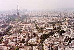
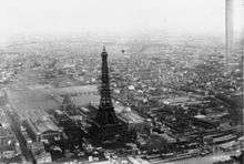
View over the 7th arrondissement, dominated by the Eiffel Tower, and the Invalides. | |
 Paris and its closest suburbs | |
| Country | France |
| Region | Île-de-France |
| Department | Paris |
| Commune | Paris |
| Government | |
| • Mayor | Rachida Dati |
| Area | |
| • Total | 4.09 km2 (1.58 sq mi) |
| Population (8 March 1999 census)[p] | |
| • Total | 56,985 |
| • Estimate (2005) | 55,400 |
| • Density | 14,000/km2 (36,000/sq mi) |
| ^[p] Population sans doubles comptes: single count of residents of multiple communes (e.g. students and military personnel). | |
 20 arrondissements of Paris | |||||||||||||||||||||||||||||||||||||
|---|---|---|---|---|---|---|---|---|---|---|---|---|---|---|---|---|---|---|---|---|---|---|---|---|---|---|---|---|---|---|---|---|---|---|---|---|---|
| |||||||||||||||||||||||||||||||||||||
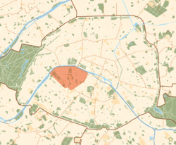
The 7th arrondissement of Paris is one of the 20 arrondissements (administrative districts) of the capital city in France. It includes some of the major tourist attractions of Paris, such as the Eiffel Tower and the Hôtel des Invalides (Napoléon's resting place), and a concentration of such world-famous museums as the Musée d'Orsay, Musée Rodin, and the Musée du quai Branly.
Situated on the Rive Gauche—the "Left", or Southern, bank of the River Seine—this central arrondissement, which includes the historical aristocratic neighbourhood of Faubourg Saint-Germain, contains a number of French national institutions, among them the French National Assembly and numerous government ministries. It is also home to many foreign diplomatic embassies, some of them occupying outstanding Hôtels particuliers.
The arrondissement has been home to the French upper class since the 17th century, when it became the new residence of French highest nobility. The district has been so fashionable within the French aristocracy that the phrase le Faubourg—referring to the ancient name of the current 7th arrondissement—has been used to describe French nobility ever since.[1] The 7th arrondissement of Paris and Neuilly-sur-Seine form the most affluent and prestigious residential area in France.[2]
History
During the 17th century, French high nobility started to move from the central Marais, the then-aristocratic district of Paris where nobles used to build their urban mansions[3] (see Hotel de Soubise), to the clearer, less populated and less polluted Faubourg Saint-Germain.
The district became so fashionable within the French aristocracy that the phrase le Faubourg has been used to describe French nobility ever since.[1] The oldest and most prestigious families of the French nobility built outstanding residences in the area, such as the Hôtel Matignon, the Hôtel de Salm, and the Hôtel Biron.
After the Revolution many of these mansions, offering magnificent inner spaces, many receptions rooms and exquisite decoration, were confiscated and turned into national institutions. The French expression "les ors de la Republique" (literally "the golds of the Republic"), referring to the luxurious environment of the national palaces (outstanding official residences and priceless works of art), comes from that time.
During the Restauration, the Faubourg recovered its past glory as the most exclusive high nobility district of Paris and was the political heart of the country, home to the Ultra Party. After the Fall of Charles X, the district lost most of its political influence but remained the center of the French upper class' social life.
During the 19th century, the arrondissement hosted no less than five Universal Exhibitions (1855, 1867, 1878, 1889, 1900) that have immensely impacted its cityscape. The Eiffel Tower and the Orsay building have been built for these Exhibitions (respectively in 1889 and 1900).
Geography
The land area of the arrondissement is 4.088 km² (1.578 sq. miles, or 1,010 acres).
Demography
The 7th arrondissement attained its peak population in 1926 when it had 110,684 inhabitants. Because it is the location of so many French government bodies, this arrondissement has never been as densely populated as some of the others. In 1999, the population was 56,985, while the arrondissement provided 76,212 jobs.
Historical population
| Year (of French censuses) |
Population | Density (inh. per km²) |
|---|---|---|
| 1872 | 78,553 | 19,206 |
| 1926 (peak year) | 110,684 | 27,075 |
| 1954 | 104,412 | 25,529 |
| 1962 | 99,584 | 24,360 |
| 1968 | 87,811 | 21,480 |
| 1975 | 74,250 | 18,163 |
| 1982 | 67,461 | 16,502 |
| 1990 | 62,939 | 15,396 |
| 1999 | 56,985 | 13,940 |
| 2009 | 57,442 | 14,045 |
Immigration
| |||||||||||||||||||
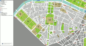
Map
Cityscape
-
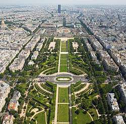
Champ-de-Mars view from the top of the Eiffel Tower
-
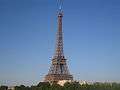
The Eiffel Tower
-
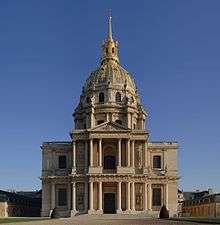
St. Louis Chapel of the Hôtel des Invalides view from avenue de Breteuil
-
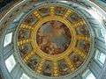
Inside Hôtel des Invalides's Chapel
-
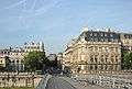
View of rue de Solferino from the Léopold-Sédar-Senghor bridge
-
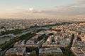
The Seine and the 7th arrondissement as seen from the Eiffel Tower
-
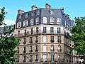
Typical Parisian architecture in the 7th arrondissement
Places of interest
Important places include:
- French National Assembly
- Eiffel Tower
- Hôtel Matignon
- Hôtel de Boisgelin (Rue de Varenne, Paris), historic building, home to the Italian embassy in Paris.
- Champ de Mars
- Musée d'Orsay
- École Militaire
- Hôtel des Invalides
- Musée du quai Branly
- Musée national de la Légion d'Honneur et des Ordres de Chevalerie
- Musée Maillol
- Musée de l'Ordre de la Libération
- Musée Rodin
- Musée Valentin Haüy
- Institut d'Etudes Politiques de Paris (Sciences Po)
Art and industry
- Musée du quai Branly
- Musée national de la Légion d'Honneur et des Ordres de Chevalerie
- Musée Maillol
- Musée de l'Ordre de la Libération
- Musée Rodin
- Musée Valentin Haüy
- National Horticultural Society of France
Economy
Air Liquide,[4] Alcatel-Lucent,[5] and Valode & Pistre have their head offices in this arrondissement.[6]
Education
Public and private high schools:
- Lycée Victor-Duruy
- Établissement La Rochefoucauld
- Institut de l'Alma
- Lycée-collège Paul-Claudel
- Lycée d'Hulst
- Lycée Sainte-Jeanne Elisabeth
- Lycée Saint-Thomas-d'Aquin
- Lycée Thérèse-Chappuis
Istituto Statale Italiano Leonardo Da Vinci, an Italian international school, maintains two campuses in the arrondissement.[7] The American University of Paris, a private liberal arts university, maintains several buildings near the Quai d'Orsay.[8]
Government
The Ministry of Agriculture, the Ministry of Foreign Affairs and the Ministry of National Education have their head offices in the arrondissement.[9][10]
Sport
The arrondissement hosted the equestrian events for the 1900 Summer Olympics.[11]
References
- 1 2 Balzac explains the very specific Faubourg's aristocratic way of life in his novel La Duchesse de Langeais
- ↑ Drouin, Olivier (2013-08-22). "Les 80 communes où se concentrent les plus hauts revenus". Capital.fr (in French). Retrieved 2016-04-19.
- ↑ Hotels particuliers
- ↑ "Legal notice." Air Liquide. Retrieved on 7 July 2010.
- ↑ "Alcatel-Lucent Fact Sheet Retrieved on 17 August 2011 "Headquarters 3 av. Octave Gréard 75007 Paris, France"
- ↑ Valode & Pistre (English) - Select "Contact". Valode & Pistre. Retrieved on 2 July 2010. "115 rue du Bac 75007 PARIS - FRANCE
- ↑ "L'OFFERTA FORMATIVA ITALIANA NELLA CIRCOSCRIZIONE CONSOLARE DI PARIGI." Italian Consulate in Paris. Retrieved on 19 October 2015. "Amministrazione, Scuola Media e Liceo Scientifico 12 rue Sédillot - 75007 Parigi" and "Scuola Elementare 3 bis Avenue de Villars - 75007 Parigi" - See map
- ↑ "University History | The American University of Paris". www.aup.edu. Retrieved 2016-06-29.
- ↑ "Mentions légales." Ministry of Agriculture. 8 June 2007. Retrieved on 6 May 2011. "Ministère de l’Agriculture, de l’Alimentation, de la Pêche, de la Ruralité et de l’Aménagement du territoire 78, rue de Varenne - 75349 Paris 07 SP"
- ↑ "à propos du site - mentions légales - crédits." Ministry of National Education. Retrieved on 6 May 2011. "Ministère de l’éducation nationale, de la jeunesse et de la vie associative Secrétariat général - Délégation à la communication 110 rue de Grenelle 75007 Paris"
- ↑ 1900 Summer Olympics official report. p. 16. Accessed 14 November 2010. (French)
External links
| Wikimedia Commons has media related to Paris 7e arrondissement. |
-
 7th arrondissement travel guide from Wikivoyage
| ||

Coordinates: 48°51′33″N 2°18′46″E / 48.85917°N 2.31278°E