A48 autoroute
| |
|---|---|
| Autoroute du Dauphiné | |
 | |
| Route information | |
|
Part of | |
| Length: | 52.5 km (32.6 mi) |
| Existed: | 1968 – present |
| Major junctions | |
| South end: | A43 |
| North end: | Grenoble |
| Highway system | |
| Autoroutes of France | |
The A48 autoroute, also known as l'autoroute du Dauphiné, is a motorway in France connecting the A43 with the city of Grenoble.
An extension north to Ambérieu is proposed in the medium term.
Characteristics
- 2x2 lanes
- 2x3 lanes between the A49 and A480 autoroutes (10 km)
- 97 km long
- Service areas
History
- 1968: The first toll free section opened between the Bastille (Grenoble northern edge) and Voreppe as part of the preparations for the Winter Olympics held in the city and surrounding area.
- 1975: Opening of the toll section between Voreppe and the A43 managed by AREA.
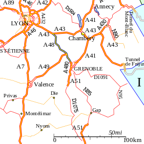
Junctions
 Exchange A48-A43 Exits [to modify] Exchanger between A43 to Lyon/Chambéry and A48
 Rest Area: Burcin
 09 (Le Grand-Lemps) Towns served: Rives
- Rest Area: Réaumont
- 10 (Champfeuillet) Towns served: Voiron
- 11 (Voiron-Moirans) Towns served: Voiron
- Exchange A49-A48 Exchanger between A49 to Valence and A48
- 12 (Veurey) Towns served: Voreppe
-
 Péage de Voreppe
 - 13 (Voreppe) Towns served: Voreppe
- Rest Area: Voreppe/L'Isle Rose
- 14 (Saint-Egreve) Towns served: Saint-Egreve
- 15 (ZI Saint-Egreve-ZI/Saint-Martin-the-Vinoux) Towns served: Grenoble
- Exchange A48-A480 Junction between the A48 and A480 to Sisteron and Gap via A51.
- 16 (Europôle-Polygon Scientific Grenoble) Towns served: Grenoble
Autoroute ends.
Places of interest
The following list indexes towns and places of interest that can be visited from the motorway:
- River Isere
- Col de Rossatière
Future
There are proposals to extend the autoroute north from Bourgoin-Jallieu to Ambérieu-in-Bugey and connecting to the A42 autoroute.
External links
- A48 autoroute in Saratlas
 |
| | |
This article is issued from Wikipedia - version of the 1/21/2016. The text is available under the Creative Commons Attribution/Share Alike but additional terms may apply for the media files.