AH48
| Asian Highway 48 | |
|---|---|
 | |
| Route information | |
| Length: | 90.58 km (56.28 mi) |
| Existed: | 2015 – present |
| Major junctions | |
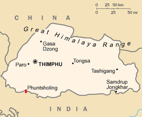
| From: | Phuentsholing |
| Jaigaon, Birpara, Gairkata, Mainaguri | |
| To: | Changrabandha |
| Location | |
| Countries: | India, Bhutan, Bangladesh |
| Highway system | |
| Asian Highway Network | |
Asian Highway 48 - AH48, colloquially known as SAARC Road, is a work-in-progress route of the Asian Highway Network, running 90.58 kilometres (56.28 mi) from Phuntsholing, Bhutan and its twin town Jaigaon, India, across the border through the Dooars region of West Bengal and ending at Changrabandha near Bangladesh border. It is being undertaken with the goal of boosting ties, trade and tourism between the SAARC countries.[1] [2]
Route
AH48, along with AH2 is part of the SASEC Road Connectivity Investment Program (SRCIP). The corridor component of Asian Highway 48 in West Bengal involves part of NH-717, NH 31, NH 31C & NH317 A. The road passes through Jaigaon – Hasimara – Madarihat – Birpara – Gairkata – Dhupguri – Mainaguri(Indira More) – Changrabandha.[3]
Timeline
For a long time, AH48 was less than a kilometer, from Phuentsholing to Jaigaon.
In February 2008, the Union Cabinet of India approved the required amendments to the existing roads, in order to upgrade them to Asian Highway 48 and Asian Highway 2[4]
The timeline for Asian Development Bank regarding the project was as follows- Concept Clearance: 16 Dec 2013 Fact-finding: 02 Dec 2013 to 17 Dec 2013 Management Review Meeting: 31 Jan 2014 Approval: 28 Mar 2014 [5]
Surveys and felling of trees were started in January 2015.
Funding
The project is being funded by the Asian Development Bank, with the bank giving its approval in March 2014. ADB has approved $500 million for the project, which includes both AH48 and section of AH2.[6]
Environmental Impact
There were environmental concerns since a two kilometre stretch of the road will be passing through the Jaldapara Wildlife Sanctuary.[7] Thousands of trees along the existing road are being felled down, some several millennia old.
Construction
The contract for the construction was secured by Punj Lloyd. The scope of work includes rehabilitation and upgrading of Bhutan border at Pasakha to Bangladesh border at Changrabandha comprising Jaigaon, Hasimara, Dhupguri section and Mainaguri-Changrabandha section.[8]
Criticism
As early as 2006, a paper by Equitable Tourism Options said that the SASEC Tourism Development Plan advocates forms of development that is environmentally damaging and economically unsustainable.[9]
External links
References
- ↑ http://indianexpress.com/article/cities/kolkata/to-boost-saarc-ties-mamata-clears-two-highway-projects/
- ↑ http://m.thehindu.com/news/cities/kolkata/bengal-proposes-road-connecting-state-with-three-countries/article6081600.ece
- ↑ http://www.pwdwb.in/uploads/tender/nit_no_adb_ah-48_social_niq-1_21012015.pdf
- ↑ http://archive.indianexpress.com/news/cabinet-okays-ah2-ah48-amendments/273133/
- ↑ http://adb.org/projects/details?page=details&proj_id=47341-001
- ↑ http://adb.org/projects/details?page=details&proj_id=47341-001
- ↑ http://www.adb.org/projects/documents/sasec-road-connectivity-sector-project-asian-highways-2-48-eia
- ↑ http://m.businesstoday.in/story/punj-lloyd-highway-contract-stock-rises/1/212476.html
- ↑ https://archive.org/download/AdbsSasecTourismDevelopmentPlanAndItsPotentialImpactsOnIndiasNe/AdbsSasecTourismDevelopmentPlanAndItsPotentialImpactsOnIndiasNortheast-15Dec06-equations.pdf ADB's SASEC Tourism Development Plan and its Potential Impacts on India's NE PDF Link|98.2 KB
| Across the whole continent | 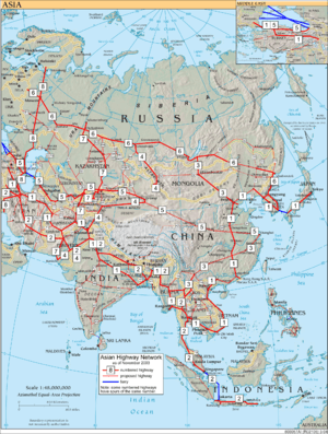 | |
|---|---|---|
| Southeast Asia | ||
| East Asia, Northeast Asia and Southeast Asia | ||
| South Asia | ||
| North Asia, Central Asia and Southwest Asia | ||