Abbadia San Salvatore
| Abbadia San Salvatore | ||
|---|---|---|
| Comune | ||
| Comune di Abbadia San Salvatore | ||
 | ||
| ||
 Abbadia San Salvatore Location of Abbadia San Salvatore in Italy | ||
| Coordinates: 42°53′N 11°41′E / 42.883°N 11.683°ECoordinates: 42°53′N 11°41′E / 42.883°N 11.683°E | ||
| Country | Italy | |
| Region | Tuscany | |
| Province / Metropolitan city | Siena (SI) | |
| Government | ||
| • Mayor | Lorenzo Avanzati | |
| Area | ||
| • Total | 58.9 km2 (22.7 sq mi) | |
| Elevation | 822 m (2,697 ft) | |
| Population (Dec. 2004)[1] | ||
| • Total | 6,807 | |
| • Density | 120/km2 (300/sq mi) | |
| Demonym(s) | Abbadenghi, Badenghi | |
| Time zone | CET (UTC+1) | |
| • Summer (DST) | CEST (UTC+2) | |
| Postal code | 53021 | |
| Dialing code | 0577 | |
| Patron saint | St. Mark | |
| Saint day | September 19 | |
| Website | Official website | |
| Wikimedia Commons has media related to Abbadia San Salvatore. |
Abbadia San Salvatore is a comune (municipality) in the Province of Siena in the Italian region Tuscany, located about 110 kilometres (68 mi) southeast of Florence and about 60 kilometres (37 mi) southeast of Siena, in the area of Monte Amiata.
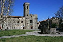
The town is named after the Abbey of the same name. The area was once important for the extraction of cinnabar. Attractions in the town include the medieval borough, the Palazzo della Potesta (15th century) and the church of Santa Croce.
Abbadia San Salvatore borders the following municipalities: Castel del Piano, Castiglione d'Orcia, Piancastagnaio, Radicofani, San Casciano dei Bagni, Santa Fiora, Seggiano.
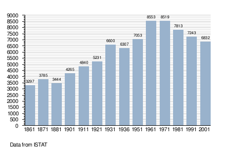
Demographic evolution
References
External links
This article is issued from Wikipedia - version of the 6/24/2015. The text is available under the Creative Commons Attribution/Share Alike but additional terms may apply for the media files.