Adbaston
| Adbaston | |
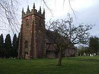 The Parish Church of Saint Michael and All Angels |
|
 Adbaston |
|
| Population | 561 (2011)[1] |
|---|---|
| – London | 153 miles |
| District | Stafford |
| Shire county | Staffordshire |
| Region | West Midlands |
| Country | England |
| Sovereign state | United Kingdom |
| Post town | STAFFORD |
| Postcode district | ST20 |
| Dialling code | 01785 |
| Police | Staffordshire |
| Fire | Staffordshire |
| Ambulance | West Midlands |
| EU Parliament | West Midlands |
|
|
Coordinates: 52°50′53″N 2°21′16″W / 52.8481°N 2.35444°W
Adbaston is a village and a civil parish in the English county of Staffordshire.[2][3]
Location
The village is 13.0 miles (20.9 km) north east of the town of Stafford, and 18.4 miles (29.6 km) south east of Stoke on Trent. The nearest railway station is at Stone. The nearest main roads are the A41 which passes the village 4.7 miles (7.6 km) to the south west.[4] The village is situated approximately halfway between towns of Eccleshall and Newport, Shropshire, and near the villages and hamlets of Cheswardine, Shropshire, and Woodseaves, High Offley and Knighton, Staffordshire.
History
Domesday Book
Adbaston is listed in the Domesday Book of 1086. In the survey the village has the name Edboldestone[5] In the survey the settlement was described as quite small with only 5.8 households.[6] Other Assets included 17 villager or villein, meadow of 15 acres, 40 smallholders and 1 slave. There was also 25 ploughlands (land for), 3 lord's plough teams, 13 men's plough teams. In 1066 the lord of the manor was held by Robert, Bishop of Chester. Before that the lord of the manor was said to have been previously Leofwine Bishop of Lichfield.
The village contains a church, "St Michael and All Angels", and a phone box. There was once a school but it closed due to diminishing numbers of children.
External links
-
 Media related to Adbaston at Wikimedia Commons
 - Adbaston in the Domesday Book
References
- ↑ "Civil Parish population 2011". Retrieved 1 December 2015.
- ↑ OS Explorer Map 243: Market Drayton, Loggerheads and Eccleshall: (1:25 000) :ISBN 0 319 46413 X
- ↑ Map Details retrieved 18 April 2013
- ↑ - Staffordshire A-Z County Atlas: 2011 Edition: Scale:3.8 inches to 1 mile (5.9cm to 1km)ISBN 978 1 84348 748 7
- ↑ The Domesday Book, Englands Heritage, Then and Now, Editor: Thomas Hinde, Staffordshire Section: ISBN 1858334403
- ↑ "Adbaston" (by Anna Powell-Smith. Domesday data created by Professor J.J.N. Palmer, University of Hull.). Open Domesday. Retrieved 2013-04-19.