Aizkorri-Aratz Natural Park
The Aizkorri-Aratz Natural Park is the second-largest natural park in the Basque Country, extending over 16,000 hectares, in the Aizkorri-Aratz Mountain Range. Included in the park are the highest summits (Aitxuri, 1,551 m) in the Cantabrian-Mediterranean watershed, which together form a massif that is a centre for Basque mountaineering. Declared a natural park in 2006, the area contains limestone ridge-and-valley and siliceous intrusion biomes.[1][2]

Location
This natural park is situated in the Basque Country, Spain. It was declared a natural park in 2006. It is located in the provinces of Gipuzkoa (80 per cent) and Alava (20 per cent). Four towns in the province of Alava are within the park – Asparrena, Zalduondo, San Millán/Donemiliaga, and Barrundia – and seven of Gipuzkoa: Leintz-Gatzaga, Eskoriatza, Aretxabaleta, Oñati, Legazpi, Zerain, and Zegama. The park includes all the lands of the "Gipuzkoa eta Arabako Partzuergo Orokorra / Parzonería General de Gipuzkoa y Álava".
Weather
The park has a humid climate, with no drought in the summer, because of the altitude. The northern slope is wetter than the southern. The climate varies from area to area due to differences in the terrain. The temperature is mild, but the winters are cold.
Landscape
Although the mountains are the most noticeable characteristic of the park, the area has vegetation, fauna, and phenomena not present in other mountainous areas.

Mountains
The park is in a mountain area near the Aralar Range, which is one of the corridors linking the Pyrenees to the Cantabrian Mountains. Highlights include the rock wall that extends between the mountains of Aloña and Aratz. The highest altitudes of the Basque Autonomous Community are the peaks of Aitxuri (1,551 metres) and Aizkorri (1,544 metres).
Substrates, vegetation and phenomena
The substrate of the area consists of urgonian limestone, which create karstic phenomena such as ridges, sinkholes, torques, and ravines. Notable formations include the basin of La Lece, the tunnel of San Adrián, Urbia's depression, and Arantzazu's ravine. In Elguea-Urkilla the substrate changes; sandstones and clays are present. In the natural park some magnificent large autochthonous forests are conserved, which contain beech and white oak (Quercus petraea). Rare vegetation is present at higher altitudes, such as mountain meadows and heather, and fruits, which are the food of the menhaden sheep.
Fauna

The fauna associated with the forest are the black woodpecker (Dryocopus martius), eagles, owls, the vultures, and more than 20 species that are protected under European legislation. Amphibians present in the ponds include the triton and the Iberian Frog. Mammals include the bobcat and the marten.
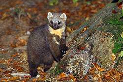
Pine marten
This animal is a mustelid, and is native to Northern Europe. Its body is up to 53 centimetres (21 in), and its bushy tail can be 25 centimetres (9.8 in). Males are slightly larger than females; on average a marten weighs around 1.5 kilograms (3.3 lb). Their fur is usually light to dark brown and grows longer and silkier during the winter months. They have a cream to yellow coloured "bib" marking on their throats.
Nocturnal and somewhat arboreal in habit, it eats small mammals, small birds, insects, and frogs. They also eat fruits and eggs of birds. Martens are occasional prey of eagles, owls, and foxes. In captivity they live up to 18 years, in the wild eight to ten years. They reach sexual maturity at two to three years. Their young, with a birth-weight of approximately 30 grams, are usually born in March or April after a seven-month-long gestation period, in litters of one to five.
Iberian frog
The Iberian frog or Rana Patilarga, Rana iberica, is a species of frog in the Ranidae family. It is native and limited to Portugal and Spain. Its natural habitats are rivers, intermittent rivers, and swamps.
Archaeological traces

Because of the karstic properties of the rock, there are many caves in the park. Most of them, including Arrikrutz and Aizkirri, have prehistoric deposits, including the remains of lions and bears. The cave at Otzaurte links Alava and Gipuzkoa. A small furnace to smelt iron from the Bronze Age has been found in the area.
In some parts of the park, it is still possible to view the Roman road to Vitoria-Gasteiz, and it is one of the trails of the Camino de Santiago. There are also roads extant from the Middle Ages, such as San Adrian's road.
Amenities for tourists
The nearest airport is Foronda (Vitoria Airport). The airport at Loiu, Vizcaya, is also nearby. The road to the park is clearly marked, and tourist accommodations are available. Restaurants and cafes are on site.
See also
References
- ↑ "Aizkorri-Aratz Natural Park", in the website of the Government of the Basque Autonomous Community.
- ↑ (Basque)(Spanish) 76/2006 Decree of the Government of the Basque Autonomous Community, declaring Aizkorri-Aratz a Natural Park, 4 April 2006.
External links
- http://www.gipuzkoaturismo.net/WAS/CORP/DITPortalTurismoPublicoWEB/Detalle.do?destino=irADetalle&seccion=PAGINA_DETALLE&buscaFN=true&codigoFN=E.4.2.1#
- http://www.totallyspain.com/spain_travel_itineries.asp?id=6
Coordinates: 42°58′48″N 2°33′00″W / 42.9800°N 2.5500°W