Akkajaure
| Akkajaure | |
|---|---|
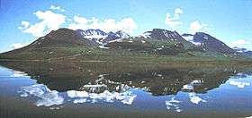 Áhkká seen from the lake | |
| Location | Norrbotten County, Lappland |
| Coordinates | 67°38′07″N 17°38′29″E / 67.63528°N 17.64139°ECoordinates: 67°38′07″N 17°38′29″E / 67.63528°N 17.64139°E |
| Type | man-made reservoir |
| Primary inflows | 55% from Voujatätno river, 25% from nine other rivers, 20% via tunnel from Sitasjaure dam[1] |
| Primary outflows | Lule River (Luleälven), below Suorva dam[1] |
| Catchment area | 4,650 km2 (1,795 sq mi)[1] |
| Basin countries | Sweden |
| Max. length | 60 km (37 mi)[1] |
| Max. width | 5 km (3.1 mi)[1] |
| Surface area | 266 km2 (103 sq mi)[1] |
| Average depth | 30 m (98 ft)[1] |
| Max. depth | 92 m (302 ft)[1] |
| Water volume | 5.9 km3 (1.4 cu mi) |
| Surface elevation | 453 m (1,486 ft)[1] |
| References | [1] |
Akkajaure (from lule sami Áhkájávrre) is one of the largest reservoirs in Sweden.[1] It lies at the headwaters of the Lule River in Norrbotten County, in Swedish Lappland, within the Stora Sjöfallet national park. The lake formed after the construction of the first Suorva dam in 1913–1923.[1] The rim of the current dam is at an elevation of 453 m (1,486 ft).[1] When full, the lake's maximum depth is 92 m (302 ft), and its mean depth is about 30 m (98 ft).[1] Because it is used for power generation, the lake depth fluctuates by up to 30 m (98 ft).[1]
References
This article is issued from Wikipedia - version of the 1/8/2016. The text is available under the Creative Commons Attribution/Share Alike but additional terms may apply for the media files.