Aksaray Province
| Aksaray Province Aksaray ili | |
|---|---|
| Province of Turkey | |
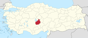 Location of Aksaray Province in Turkey | |
| Country | Turkey |
| Region | Central Anatolia |
| Subregion | Kırıkkale |
| Government | |
| • Electoral district | Aksaray |
| Area | |
| • Total | 7,626 km2 (2,944 sq mi) |
| Population (2010-12-31)[1] | |
| • Total | 377,505 |
| • Density | 50/km2 (130/sq mi) |
| Area code(s) | 0382 |
| Vehicle registration | 68 |
Aksaray Province (Turkish: Aksaray ili) is a province in central Turkey. Its adjacent provinces are Konya along the west and south, Niğde to the southeast, Nevşehir to the east, and Kırşehir to the north. It covers an area of 7,626 km². The provincial capital is the city of Aksaray.
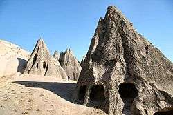
This is a region of great natural beauty: Aksaray is one of the four provinces in the much-visited area of Cappadocia, along with Nevşehir, Niğde and Kayseri. Also the 3,000m volcano Mount Hasan stands between Aksaray and Niğde. Summers are hot and dry on the plain, but the area is green and covered in flowers in springtime, when water streams off the mountainside. The 2400 km² salt lake, Tuz Gölü, lies within the boundaries of Aksaray, a large area of swamp with a maximum depth of 1 metre.
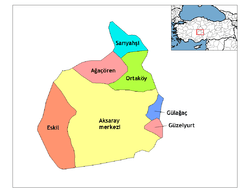
Districts
Aksaray province is divided into 7 districts (capital district in bold):
Etymology
In antiquity the area was named Archelais Garsaura, which was mutated to Taksara during the Seljuk Turkish era, and then to Aksaray.
History
The plains of central Anatolia have been settled for 8,000 years. and the area around Aksaray bears monuments to a string of civilisations that have settled on the plain in that time. The mound of Aşıklı Höyük in the town of Kızılkaya indicates a settlement dating back to 5,000BC (and also a skull of a woman who had apparently been trepanned, the earliest known record of brain surgery).
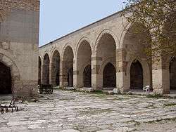
Later the Silk Road came through here so caravanserai and then larger and larger settlements were built to supply and shelter travellers and traders. The city and surroundings of Aksaray thrived in the Roman, Byzantine and the Turkish periods.
Today Aksaray is a rural, agricultural province, its people religious and conservative. Since the 1950s many have moved to Europe as migrant workers. The population of Aksaray has long included a higher proportion of Kurdish people than most central Anatolian provinces. Many of them were resettled here from Tunceli and other eastern cities following the Sheikh Said rebellion in the 1920s.[2]
Places of interest
- Aşıklı Höyük - a Neolithic settlement 25 km east of the city of Aksaray.
- Acemhöyük - an early Bronze Age settlement, 18 km north-west of the city of Aksaray.
- The ancient city of Nora, in the village of Helvadere near the city of Aksaray.
and a great number of historical mosques and churches
- Ihlara valley - a canyon, 40 km from the city of Aksaray, in the district of Güzelyurt
- Taşpınar - famous for rugs, 27 kilometres (17 mi) south of Aksaray
See also
References
- ↑ Turkish Statistical Institute, MS Excel document – Population of province/district centers and towns/villages and population growth rate by provinces
- ↑ TÜRK OTAĞI || Türkçüler ve Türkçülük
- Site di Aksaray (Turkish)
External links
| Wikimedia Commons has media related to Aksaray Province. |
- Aksaray governor's official website
- (Turkish) Aksaray municipality's official website
- High resolution pictures of the city
- Aksaray weather forecast information
- (Turkish) Aksaray University student websites
- Aksaray Kapadokya tarihi map information
| ||
Metropolitan municipalities are bolded. | ||
Coordinates: 38°25′51″N 33°51′44″E / 38.43083°N 33.86222°E