Aksuat
| Aksuat | |
|---|---|
 Aksuat | |
| Coordinates: 47°45′43.95″N 82°48′5.85″E / 47.7622083°N 82.8016250°ECoordinates: 47°45′43.95″N 82°48′5.85″E / 47.7622083°N 82.8016250°E | |
| Country |
|
| Region | East Kazakhstan Region |
| District | Tarbagatay District |
| Government | |
| • Type | Akimat |
| • Akim | Uvaliyev Toktar |
| Elevation | 1,781 ft (543 m) |
| Time zone | +6 (UTC+6) |
| Post code | 071500 -071515 |
| Area code(s) | +7 72346 |
| Website |
tarbagatay |
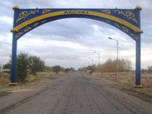
Aksuat (Kazakh: Ақсуат, Russian: Аксуа́т) is a selo in Tarbagatay District in the East Kazakhstan Region. It is the administrative center of the district. Population: 6,126 (2009 Census results);[1] 7,503 (1999 Census results).[1]
Toponomy
The name Aksuat derives from two Kazakh words: ақ (ak)= white and суат (suat)= pond.
Climate
Very continental. Winter is cold (in January average temperature – 22°С, – 30°С) and summer is hot (in July average temperature + 25°С, + 35°С). Very poor precipitation (200 – 300 mm/year) mostly in the winter season.[2]
References
- 1 2 "Население Республики Казахстан" (in Russian). Департамент социальной и демографической статистики. Retrieved 8 December 2013.
- ↑ Archived February 21, 2008, at the Wayback Machine.
External links
Capital: Oskemen | ||
| Districts |  | |
| Major cities | ||
This article is issued from Wikipedia - version of the 11/17/2016. The text is available under the Creative Commons Attribution/Share Alike but additional terms may apply for the media files.