Algiers Metro Line 1
| Algiers Metro Line 1 | |
|---|---|
|
| |
 | |
| Overview | |
| Type | Rubber-tyred metro |
| System | Algiers Metro |
| Status | Active |
| Locale | Algiers |
| Termini |
Tafourah - Grande Poste Station El Harrach Centre Station |
| Stations | 14 |
| Operation | |
| Opened | November 1, 2011 |
| Operator(s) | RATP El-Djazaïr (FR) |
| Technical | |
| Track length | .km |
| Operating speed | 72kmh |
Algiers Metro Line 1 is the first line that makes up the Algiers Metro network.
History
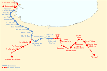
Map of Algiers Metro Line 1
With a length of 9.5 kilometres (5.9 miles), the first section of Line 1 includes ten stations, connecting Tafourah - Grande Poste to Haï El Badr. Nine of the ten stations are underground with two central tracks flanked by two 115 metres (377 ft) long side platforms. Only the Haï El Badr terminus station is on the surface and it has three tracks and two island platforms.
- The El Hamma - Haï El Badr section, with its 4 stations and 17 other works for ventilation and cables was carried out within 38 months. Civil engineering work and rail laying were officially completed on June 30, 2007.
- The installation and the welding of 23 km of tracks was started in April 2007 by the French company South-western Travaux France (TSO) with the first metro car to be delivered to Algiers by December 2007.
Communes served by Line 1
Line 1 serves the following Algiers communes from west to east:
- Kasbah
- Alger Centre
- Sidi M'Hamed
- Belouizdad
- Hussein Dey
- El Magharia
- Baraki
- Gué de Constantine
- Bachdjerrah
- Bourouba
- El Harrach
- Oued Smar
- Bab Ezzouar
- Dar El Beïda
Stations
Gallery
-

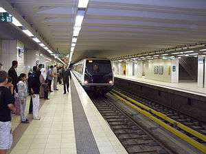
Grande Poste Algiers.
-

Vestibule of the station.
See also
References
| Line 1 Red |
|  |
|---|---|---|
| Line 2 Green (planned) | ||
| Line 3 Blue (planned) | ||
This article is issued from Wikipedia - version of the 8/22/2016. The text is available under the Creative Commons Attribution/Share Alike but additional terms may apply for the media files.