Alma, Wisconsin
| Alma, Wisconsin | |
|---|---|
| City | |
|
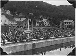
Alma at the 1935 dedication of Lock and Dam No. 4 | |
 Location of Alma, Wisconsin | |
| Coordinates: 44°20′24″N 91°55′28″W / 44.34000°N 91.92444°WCoordinates: 44°20′24″N 91°55′28″W / 44.34000°N 91.92444°W[1] | |
| Country | United States |
| State | Wisconsin |
| County | Buffalo |
| Government | |
| Area[2] | |
| • Total | 7.91 sq mi (20.49 km2) |
| • Land | 5.27 sq mi (13.65 km2) |
| • Water | 2.64 sq mi (6.84 km2) |
| Elevation[3] | 673 ft (205 m) |
| Population (2010)[4] | |
| • Total | 781 |
| • Estimate (2012[5]) | 764 |
| • Density | 148.2/sq mi (57.2/km2) |
| Time zone | Central (CST) (UTC-6) |
| • Summer (DST) | CDT (UTC-5) |
| Zip Code | 54610 |
| Area code(s) | 608 |
| FIPS code | 55-01225[6] |
| GNIS feature ID | 1560795[3] |
| Website |
cityofalmawi |
Alma is a city in and the county seat of Buffalo County[7] in the U.S. state of Wisconsin. The population was 781 at the 2010 census. The city borders the Town of Alma (to its east), as well as the Town of Nelson (to its north), the Town of Belvidere (to its southeast), and Greenfield Township, Wabasha County, Minnesota (across the Mississippi River to its west). The motto for the city of Alma is: "Step into Living History."
History
Alma was named in commemoration of the Battle of Alma, in the Crimean War.[8]
Geography
Alma is located on State Route 35. Is about 6 miles (9.7 km) east of Wabasha, Minnesota.
According to the United States Census Bureau, the city has a total area of 7.91 square miles (20.49 km2), of which, 5.27 square miles (13.65 km2) is land and 2.64 square miles (6.84 km2) is water.[2]
Demographics
| Historical population | |||
|---|---|---|---|
| Census | Pop. | %± | |
| 1870 | 565 | — | |
| 1880 | 1,244 | 120.2% | |
| 1890 | 1,428 | 14.8% | |
| 1900 | 1,201 | −15.9% | |
| 1910 | 1,011 | −15.8% | |
| 1920 | 970 | −4.1% | |
| 1930 | 1,009 | 4.0% | |
| 1940 | 1,139 | 12.9% | |
| 1950 | 1,068 | −6.2% | |
| 1960 | 1,008 | −5.6% | |
| 1970 | 956 | −5.2% | |
| 1980 | 848 | −11.3% | |
| 1990 | 790 | −6.8% | |
| 2000 | 942 | 19.2% | |
| 2010 | 781 | −17.1% | |
| Est. 2015 | 748 | [9] | −4.2% |
2010 census
As of the census[4] of 2010, there were 781 people, 386 households, and 202 families residing in the city. The population density was 148.2 inhabitants per square mile (57.2/km2). There were 488 housing units at an average density of 92.6 per square mile (35.8/km2). The racial makeup of the city was 98.5% White, 0.1% African American, 0.4% Native American, 0.1% Asian, and 0.9% from two or more races. Hispanic or Latino of any race were 0.6% of the population.
There were 386 households of which 17.1% had children under the age of 18 living with them, 41.7% were married couples living together, 7.3% had a female householder with no husband present, 3.4% had a male householder with no wife present, and 47.7% were non-families. 41.2% of all households were made up of individuals and 21% had someone living alone who was 65 years of age or older. The average household size was 1.95 and the average family size was 2.62.
The median age in the city was 50.3 years. 15.4% of residents were under the age of 18; 5.8% were between the ages of 18 and 24; 21.3% were from 25 to 44; 30% were from 45 to 64; and 27.5% were 65 years of age or older. The gender makeup of the city was 51.0% male and 49.0% female.
2000 census
As of the census[6] of 2000, there were 942 people, 421 households, and 261 families residing in the city. The population density was 160.8 people per square mile (62.1/km²). There were 495 housing units at an average density of 84.5 per square mile (32.6/km²). The racial makeup of the city was 97.03% White, 0.21% Black or African American, 0.85% Native American, 0.32% Asian, 0.11% Pacific Islander, and 1.49% from two or more races. 0.85% of the population were Hispanic or Latino of any race.
There were 421 households out of which 23.0% had children under the age of 18 living with them, 52.5% were married couples living together, 6.4% had a female householder with no husband present, and 37.8% were non-families. 31.4% of all households were made up of individuals and 14.5% had someone living alone who was 65 years of age or older. The average household size was 2.20 and the average family size was 2.74.
In the city the population was spread out with 19.7% under the age of 18, 7.6% from 18 to 24, 25.5% from 25 to 44, 23.1% from 45 to 64, and 24.0% who were 65 years of age or older. The median age was 43 years. For every 100 females there were 98.3 males. For every 100 females age 18 and over, there were 97.9 males.
The median income for a household in the city was $34,250, and the median income for a family was $45,625. Males had a median income of $31,806 versus $21,250 for females. The per capita income for the city was $21,885. About 5.6% of families and 8.9% of the population were below the poverty line, including 5.8% of those under age 18 and 14.5% of those age 65 or over.
Economy and recreation
The Great Alma Fishing Float has been an attraction to tourists, and is particularly popular during the annual walleye run. It is located next to Lock & Dam Number 4 on the Mississippi River.[11] Mississippi River Lock and Dam No. 4, is a major nesting ground for the bald eagles that can be observed with great frequency from Alma's riverbank. Also located in Alma is Castlerock Museum, a collection of arms and armor from the times of the Romans to the Middle Ages.
Power stations
Notable people
- Carol Bartz, CEO of Yahoo!, former chairman of the board, president, and CEO of Autodesk, Inc.
- John W. DeGroff, Member of the Wisconsin Senate from the 24th district
- Arnold Gesell, psychologist
- Edmund Hitt, Wisconsin state legislator
- John Hunner, Wisconsin State Treasurer
- Doug Kane, Illinois legislator
- Robert Lees, Wisconsin state legislator
- James Arthur Mathieu, Canadian lumber king
- Conrad Moser, Jr., Wisconsin state legislator
- Peter Polin, Wisconsin politician and businessman
- Frank Schaettle, Wisconsin state legislator
- John Tester, businessman and Wisconsin state legislator
- Kathleen Vinehout, Member of the Wisconsin Senate from the 31st district
References
- ↑ "US Gazetteer files: 2010, 2000, and 1990". United States Census Bureau. 2011-02-12. Retrieved 2011-04-23.
- 1 2 "US Gazetteer files 2010". United States Census Bureau. Archived from the original on 2012-01-24. Retrieved 2012-11-18.
- 1 2 "US Board on Geographic Names". United States Geological Survey. 2007-10-25. Retrieved 2008-01-31.
- 1 2 "American FactFinder". United States Census Bureau. Retrieved 2012-11-18.
- ↑ "Population Estimates". United States Census Bureau. Archived from the original on 2013-06-17. Retrieved 2013-06-24.
- 1 2 "American FactFinder". United States Census Bureau. Archived from the original on 2013-09-11. Retrieved 2008-01-31.
- ↑ "Find a County". National Association of Counties. Archived from the original on 2011-05-31. Retrieved 2011-06-07.
- ↑ History of the Origin of the Place Names in Nine Northwestern States. 1908. p. 12.
- ↑ "Annual Estimates of the Resident Population for Incorporated Places: April 1, 2010 to July 1, 2015". Retrieved July 2, 2016.
- ↑ "Census of Population and Housing". Census.gov. Archived from the original on May 11, 2015. Retrieved June 4, 2015.
- ↑ The Great Alma Fishing Float
External links
- City of Alma
- Alma Chamber of Commerce website
- Sanborn fire insurance maps: 1889 1894 1900 1910
Municipalities and communities of Buffalo County, Wisconsin, United States | ||
|---|---|---|
| Cities | 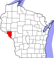 | |
| Villages | ||
| Towns | ||
| CDP | ||
| Unincorporated communities | ||
| Ghost towns | ||