Almendres Cromlech
| Cromlech of the Almendres (Cromeleque dos Almendres) | |
| Cromlech (Cromeleque) | |
 The Cromlech of the Almendres overlooking the civil parish of Nossa Senhora de Guadalupe | |
| Nickname: Alto das Pedras Talhas | |
| Country | |
|---|---|
| Region | Alentejo |
| Sub-region | Alentejo Central |
| District | Évora |
| Municipality | Évora |
| Location | Nossa Senhora de Guadalupe |
| - elevation | 400 m (1,312 ft) |
| - coordinates | PT 38°33′26.91″N 8°3′40.03″W / 38.5574750°N 8.0611194°WCoordinates: PT 38°33′26.91″N 8°3′40.03″W / 38.5574750°N 8.0611194°W |
| Length | 0.06 m (0 ft), West-East |
| Width | 0.03 m (0 ft), North-South |
| Architects | unknown |
| Style | Megalithic |
| Material | Granite |
| Discovered | 1966 |
| - Initiated | 6000 BC |
| - Completion | 3000 BC |
| Owner | Portuguese Republic |
| For public | Private |
| Visitation | Open |
| Management | Instituto Gestão do Patrimonio Arquitectónico e Arqueológico |
| Status | Property of Public Interest |
| Listing | Decree No. 735/74; DG 297, 21 December 1974 |
| Wikimedia Commons: Cromeleque dos Almendres | |
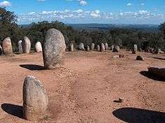
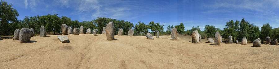
The Cromlech of the Almendres megalithic complex (or Almendres Cromlech), located near Guadalupe, in the civil parish of Nossa Senhora de Guadalupe, municipality of Évora, Portugal, is the largest existing group of structured menhirs in the Iberian Peninsula, and one of the largest in Europe. This archaeological site consists of several megalithic structures: cromlechs, and menhir stones, the first belonging to the so-called "megalithic universe of Évora", with clear parallels to other cromlechs, such as in Portela Mogos in the Montemor-o-Novo.[1]
History
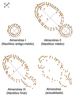
The construction of these structures date back to the 6th millennium BC, though they were only rediscovered in 1966 by Henrique Leonor Pina, who was proceeding with field work relating to the country's geological charts.[1][3][4][5] The excavation of the site unearthed a series of both megalithic and neolithic construction phases; Almendres I 6000 BC (Early Neolithic), Almendres II 5000 BC (Middle Neolithic), Almendres III 4000 BC (Late Neolithic). The relative chronology of the cromlech and menhirs is extremely complex and covers a period from the Neolithic to Chalcolithic, and it is believed that the monument had a religious/ceremonial purpose, or functioned as a primitive astronomical observatory.[1][5]
Architecture
Located off the national roadway from Évora to Montemor-o-Novo, in the civil parish of Nossa Senhora de Guadalupe, it is situated just after the village of Guadalupe, in Herdade dos Almendres.[1][5] The cromlech is located within the property, 1.5 kilometres southwest, while the menhir is sited on the limits of the residence to the east.[1][5] The location is a rural area on the southeast flank at a slope facing the sun rise of the Serra de Monfurado, isolated from the local community. A pedestrian trail was defined by the local municipal council, and integrated into the municipality's "megalithic route" that follows the prehistoric remnants through the region.[5]
The complex, organized in a circular pattern, is marked by a forest of about 95 granite monoliths, deposited in small agglomerations.[1] The older (Early Neolithic) are designated by two or three concentric circles of smaller monoliths in the western part of the complex, while the mid (Middle Neolithic) structures consist of two ellipses (irregular but concentric) and large menhirs. In the Late Neolithic phase both structures suffered modifications, transforming into a site for social or religious rituals.[5] Ninety-two of the menhirs form two grounds, which were built and oriented to different directions associated with the Equinox.[5]
Many of the stones were unearthed where they stood/fell, and were rebuilt/erected by Mario Varela Gomes, based on criteria established from research and rediscovery of the original bases.[3][5][6] The complex's latitudinal position is about the same as the maximum moon elongation (38.55 degrees for 1500 BC); comparably, another latitude where this occurs is associated with Stonehenge (51.18 degrees for 2000 BC).[3]
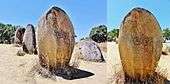
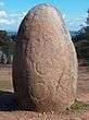
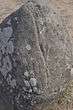
Although many are large solitary 2.5 to 3.5 metres rounded/elliptical stones, most are predominantly with small, squat agglomerations of stone.[1] The group is disseminated in an area of 70 by 40 metres, oriented along an axial alignment northwest to southeast. The columns show signs of profound erosion, especially in those surfaces exposed to the elements, although decoration is still visible. These designs take the form of lines and radials, at least two on each stone.[5]
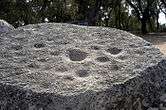
About a dozen monoliths present some form of carved drawings,[1] four of which exhibit only small circular holes. Monolith number 8, with a cut flat top at about breast level and showing several dimples, might have served for finer astronomical observation, specially spring equinox observation, by putting small stones on them. These observations might be made from stone 39, on the eastern focal point of the elliptic layout.[3] Menhir 48, also exhibits a schematized anthropomorphic representation, surrounded by circles and associated with a crozier.[1]
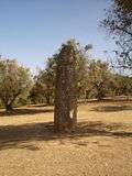
A isolated single menhir, approximately 4.5 metres tall and 0.9 metres in diameter is located near the residences, or 1400 metres northeast of the main complex. A line from the Almendres Cromlech to this menhir points roughly towards the sunrise in the Winter solstice.[3]
Views

Gallery
|

References
- Notes
- 1 2 3 4 5 6 7 8 9 IGESPAR, ed. (2011). "Cromeleque, Menir e Pedras dos Almendres" (in Portuguese). Lisbon, Portugal: IGESPAR-Instituto de Gestão do Património Arquitectónico e Arqueológico. Retrieved 19 October 2011.
- ↑ Mário Varela Gomes. Cromeleque dos Almendres: Um dos Primeiros Grandes Monumentos Públicos da Humanidade. Biblioteca Digital do Alentejo
- 1 2 3 4 5 Marciano, C., Sobre o Possível Significado Astronómico do Cromeleque dos Almendres (in Portuguese), archived from the original on 22 February 2006, retrieved 30 October 2008
- ↑ Pina, H.L. (1971), "Novos Monumentos Megalíticos do Distrito de Évora", Actas do II Congresso Nacional de Arqueologia, Coimbra, Portugal, p. 151
- 1 2 3 4 5 6 7 8 9 Branco, Manuel (1993). SIPA, ed. "Cromeleque e menir, na Herdade dos Almendres" (in Portuguese). Lisbon, Portugal: SIPA – Sistema de Informação para o Património Arquitectónico. Retrieved 19 October 2011.
- ↑ Alvim, P. (1996–1997), "Sobre alguns vestígios de paleoastronomia no Cromeleque de Almendres", A Cidade de Évora (in Portuguese), II (2), pp. 5–23
- Sources
- Gonçalves, José Pires (1975), Roteiro de Alguns Megálitos da Região de Évora (in Portuguese), Évora, Portugal
- Varela Gomes, Mário (1979), "Aspects of Megalithic Religion According to the Portuguese Menhirs", Valcamonica Symposium, III, Capo di Monte, Italy
- Santos, M. Farinha dos (1985), Pré-História de Portugal (in Portuguese), Lisbon, Portugal
- Gonçalves, José Pires; Varela Gomes, Mário; Santos, M. Farinha dos (1986), "Os Menires da Pedra Longa", Arqueologia e História, Lisbon, Portugal
- Silva, António Carlos, ed. (1992), Roteiro do Megalitismo de Évora (in Portuguese), Èvora, Portugal: Câmara Municipal de Évora
External links
- Câmara Municipal de Évora Archaeology site
- The Megalithic Portal: Cromlech of the Almendres
- The Megalithic Portal: Menhir of the Almendres
- 360° Photos
- Megalithomania
- GEMA - Grupo de Estudos do Megalitismo Alentejano (Alentejo Megalithic Study Group)
- Photos of the Almendres Cromlech