Almyros
| Almyros Αλμυρός | |
|---|---|
|
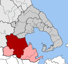
Almyros municipality (red and pink) and municipal unit (red) | |
 Almyros | |
|
Location within the region  | |
| Coordinates: 39°10.8′N 22°45.6′E / 39.1800°N 22.7600°ECoordinates: 39°10.8′N 22°45.6′E / 39.1800°N 22.7600°E | |
| Country | Greece |
| Administrative region | Thessaly |
| Regional unit | Magnesia |
| Government | |
| • Mayor | Dimitrios Eseridis |
| Area | |
| • Municipality | 905.4 km2 (349.6 sq mi) |
| • Municipal unit | 473.9 km2 (183.0 sq mi) |
| Elevation | 70 m (230 ft) |
| Population (2011)[1] | |
| • Municipality | 18,614 |
| • Municipality density | 21/km2 (53/sq mi) |
| • Municipal unit | 12,678 |
| • Municipal unit density | 27/km2 (69/sq mi) |
| Community[1] | |
| • Population | 8,220 (2011) |
| Time zone | EET (UTC+2) |
| • Summer (DST) | EEST (UTC+3) |
| Postal code | 371 00 |
| Area code(s) | 24220 |
| Vehicle registration | ΒΟ |
| Website | almyros-city.gr |
Almyros or Halmyros (Greek: Αλμυρός, which means salty) is a town and a municipality of the regional unit of Magnesia, region of Thessaly, Greece. It lies in the center of prosperous fertile plain known as 'Krokio Pedio', which is crossed by torrents. Almyros is an important agricultural and commercial center of Magnesia, and is also developing as a tourist center for the area. The main agricultural products are tomatoes, cotton, wheat, almonds, peanuts and pistachio nuts.
History
The history of Almyros begins with the ancient city of Alos (about 10 km south of Almyros), the ruins of which can still be visited. Alos was a very important and populous town, famous for its port and for its role in the Persian Wars. After the Byzantine Empire, because of pirate raids, they built the town in the place that it is today.
Halmyros was the site of the decisive Battle of Halmyros on 15 March 1311, where the Catalan Company shattered the assembled feudal armies of Frankish Greece and conquered the Duchy of Athens.
In 1838, the settlement was described as being "a Turkish town, situated on the western coast of the Pagasitic Gulf, half an hour's journey inland, on the Plain of Krokios, and consisting of some 300 dwellings. It is chiefly inhabited by Turks, with only a few Christian settlers, who cultivate the lands of the Turks residing there".[2] The Ottoman Empire ceded most of Thessaly in 1881, followed by development and repopulation by Greeks.
In 1980 a catastrophic magnitude 6.5 earthquake destroyed most of the town.[3]
Municipality
The municipality Almyros was formed at the 2011 local government reform by the merger of the following 4 former municipalities, that became municipal units:[4]
The municipality has an area of 905.364 km2, the municipal unit 473.940 km2.[5]
Subdivisions
The municipal unit of Almyros is divided into the following communities: Almyros, Efxeinoupoli, Anthotopos, Kokkotoi, Kroki, Kofoi, Platanos, and Fylaki.
Province
The province of Almyros (Greek: Επαρχία Αλμυρού) was one of the provinces of Magnesia. It had the same territory as the present municipality.[6] It was abolished in 2006.
Landmarks
- The Archaeological Museum of Almyros includes local artifacts and exhibits from the Neolithic period, through Mycenean, Geometric, Classical, Hellenistic periods, and later Roman years.[7] Opposite the museum is the old High School, the Gymnasium of Almyros, which is a classic monumental building from the beginning of the 20th century. The Museum and Gymnasium are the oldest buildings in the area.
- The Kouri forest, about 2 km from the town of Almyros, at an elevation of 75m, encompasses 108 ha[8] of lowland oak forest. The forest is flat (elevation gadient is less than 2%). Oaks belong to the species: Quercus pubescens, Quercus aegilops, Quercus pedunculiflora.[9] There are footpaths, as well as a miniature train for a brief tour through the woods and over small bridges.[10]
- The area is important to migratory birds, such as the mute swan, spoonbill, glossy ibis, and various herons.
- South of the town are the moderately wooded Othrys mountains. 17 km from the town of Almyros but still in Almyros province, high in the Othrys mountains, is the 12th century Monastery of Panagia Xenia, with wall paintings, treasuries, and a library.[11][12]
- There are several sandy beaches in the municipality of Almyros.
Geography
Almyros is situated near the western end of the Pagasetic Gulf, 25 km southwest of Volos. Motorway 1 (Athens - Thessaloniki) passes east of the town Almyros.
Historical population
| Year | Town | Municipal unit | Municipality |
|---|---|---|---|
| 1981 | 6,730[13] | - | - |
| 1991 | 8,502 | 14,046[14] | - |
| 2001 | 7,921 | 12,987[14] | - |
| 2011 | 8,220 | 12,678 | 18,614[1] |
References
- 1 2 3 "Απογραφή Πληθυσμού - Κατοικιών 2011. ΜΟΝΙΜΟΣ Πληθυσμός" (in Greek). Hellenic Statistical Authority.
- ↑ Almyros History. Retrieved 2007-07-12.
- ↑ Drakos, Antonis G.; Stathis C. Stiros; Anastasia A. Kiratzi. (December 2001). "Fault Parameters of the 1980 (Mw 6.5) Volos, Central Greece, Earthquake from Inversion of Repeated Leveling Data". Bulletin of the Seismological Society of America. bssa.geoscienceworld.org. Retrieved 2007-07-12.
- ↑ Kallikratis law Greece Ministry of Interior (Greek)
- ↑ "Population & housing census 2001 (incl. area and average elevation)" (PDF) (in Greek). National Statistical Service of Greece.
- ↑ "Detailed census results 1991" (PDF). (39 MB) (Greek) (French)
- ↑ Almyros' Archaeological Museum .Retrieved 2014-02-27.
- ↑ "NatureBank - Τοπίο (ΤΙΦΚ) - Αισθητικό Δάσος Κουρί Αλμυρού". filotis.itia.ntua.gr. Retrieved 2016-03-12.
- ↑ "Ανάλυση και αξιολόγηση του «Κουρί» Αλμυρού Μαγνησίας : αειφορικός σχεδιασμός και διαχείριση του τοπίου της πολιτισμικής μας κληρονομιάς". Aristotle University of Thessaloniki Institutional Repository - IKEE. Retrieved 2016-03-12.
- ↑ Kouri Almyrou Hellenic Republic Ministry of Tourism. Retrieved 2007-07-12.
- ↑ Magnesia Greece, History and Christianity Pelion. Thegreektravel.com (commercial website). Retrieved 2007-07-12.
- ↑ The Sights of Almiros Greek Travel Pages (commercial website). Retrieved 2007-07-12.
- ↑ Almyros (ALS), Town, Magnesia Greek Travel Pages (commercial website). Retrieved 2007-07-11.
- 1 2 Athena 2001 Hellenic Republic Ministry of Economy and Finance, National Statistical Service of Greece. Retrieved 2007-07-11.
External links
| Wikivoyage has a travel guide for Almyros. |
- Almyros Newspaper
- Agios Dimitrios Church in Almyros TrekEarth. Site includes several dozen photographs in and around Almyros, including the Kouri forest, Monastery of Panagia Xenia, and Almyros beach.
- The Jewish Community of Volos "KIS, the Central Board of Jewish Communities in Greece" website. Includes history of Jewish communities in the Almyros region.
 |
Polydamantas, Feres | Nea Anchialos | | |
| Narthaki | |
Pagasetic Gulf | ||
| ||||
| | ||||
| Anavra | Echinaioi | Sourpi |
Administrative division of the Thessaly Region | ||
|---|---|---|
| Regional unit of Karditsa | 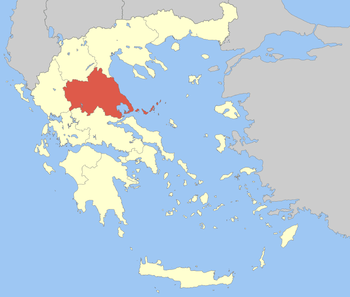 | |
| Regional unit of Larissa | ||
| Regional unit of Magnesia | ||
| Regional unit of the Sporades | ||
| Regional unit of Trikala | ||
| ||