Alsek River
| Alsek River | |
| River | |
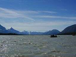 Confluence of the Alsek and Tatshenshini rivers | |
| Countries | United States, Canada |
|---|---|
| State | Alaska |
| Province | Yukon, British Columbia |
| Source | Kluane National Park and Reserve |
| - coordinates | 60°38′46″N 137°48′26″W / 60.64611°N 137.80722°W |
| Mouth | Pacific Ocean |
| - location | Dry Bay, Yakutat City and Borough, Alaska, Alaska |
| - elevation | 0 m (0 ft) |
| - coordinates | 59°7′40″N 138°37′14″W / 59.12778°N 138.62056°WCoordinates: 59°7′40″N 138°37′14″W / 59.12778°N 138.62056°W [1] |
| Basin | 28,023 km2 (10,819.7 sq mi) [2] |
| Discharge | |
| - average | 862.6 m3/s (30,462 cu ft/s) [2] |
The Alsek River (/ˈælˌsɛk/; Tlingit Aalseix̱) is a wilderness river flowing from Yukon into Northern British Columbia and into Alaska.[3] It enters the Gulf of Alaska at Dry Bay.
Most of the Alsek River's basin is within protected wilderness areas and National Parks.[2] The Alsek and its main tributary, the Tatshenshini River, are part of the Canadian Heritage Rivers System and a UNESCO World Heritage Site.[2]
Course

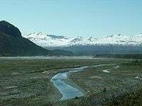
The Alsek starts at the confluence of the Dezadeash River and Kaskawulsh River in Kluane National Park and Reserve. After flowing south into the northwestern tip of British Columbia, it is joined by the Tatshenshini River in Tatshenshini-Alsek Park. It reaches the Pacific Ocean at Dry Bay, in the Gulf of Alaska, south of Yakutat, Alaska, close to the northern end of the Alaska Panhandle. Although the river is navigable by kayak or rubber raft in its northern reaches, it rapidly becomes unnavigable—for any but the most experienced and skilled kayakers—at Turnback Canyon.
On older maps, the Alsek river is labeled as the Kaskawulsh and The Tatshenshini as the Alsek. Some Yukon First Nation elders also refer to the river as the Kaskawulsh.
The river flows next to the Lowell glacier which has sometimes blocked off the river and created a large lake behind it, "Neoglacial Lake Alsek." The last such blockage took place in 1850; its release created a massive flood, washing away everything in its path on the way to the Pacific.[4]
The river carries a lot of silt from the Alsek lake/glacier, which contributes to the river's low temperature.
The Alsek and nearby East Alsek rivers were at one time connected, and the old river bed can still be made out on some maps.
The Alsek glacier contacts the Grand Plateau Glacier, which faces the shoreline. Also in the same general area are the Doame foothills and Doame River.
History
The first known kayak descent of Turnback Canyon was by Walt Blackadar, who ran the canyon solo on August 25, 1971. He wrote about his trip for Sports Illustrated.[5] "This has been a day!," he wrote in his journal. "I want any other kayaker or would-be expert to read my words well. The Alsek Gorge is unpaddleable!" Despite this sincere warning from a man who apparently felt lucky to be alive, groups of expert kayakers have successfully run Turnback Canyon since then.[6][7] A prominent mountain which overlooks the Alsek was named Mount Blackadar in his honor.
The portion of the river inside Kluane National Park has been designated a Canadian Heritage River.
In 1958, a magnitude 7.7 earthquake centered near Lituya bay significantly changed the lay of the land.[8] The earthquake caused the Doame River and East Alsek River to join together.
Fishing
The Alsek and East Alsek rivers are a part of the Yakutat area limited entry set gillnet fishery.[9] Both rivers produce king, silver, and sockeye commercially. Chum and pink salmon can also be caught, but are not generally sought after due to their relative lack of worth/quality. These two rivers can be characterized as low volume fisheries, while the Alsek river in particular produces particularly high quality salmon due to its low temperature. The Alsek's silt content also prevents the sun from damaging the fish.
The area also supports subsistence and sport fishing. There are multiple local sport fishing, sight-seeing, hunting, and animal watching lodges
See also
References
- ↑ U.S. Geological Survey Geographic Names Information System: Alsek River
- 1 2 3 4 Benke, Arthur C.; Cushing, Colbert E. (2011). Rivers of North America. Academic Press. p. 771. ISBN 978-0-08-045418-4.
- ↑ "Alsek River". BC Geographical Names.
- ↑ Yukon Geological Survey, Lowell Glacier. Retrieved 19 November 2013.
- ↑ http://sportsillustrated.cnn.com/vault/article/magazine/MAG1086409/index.htm
- ↑ Kayak Session, Triple Crown: Alsek River, October 3rd, 2014. Retrieved June 24, 2015.
- ↑ Scott Lindgren, Canoe & Kayak, Rob Lesser and the Legend of the Stikine, February 18, 2014. Retrieved June 24, 2015.
- ↑ USGS. Lituya earthquake
- ↑ Government of Alaska. Yakutat area fishing
Further reading
- Cassidy, Jim, and Dunlap, Dan (1999). World Whitewater: A Global Guide for River Runners. McGraw-Hill. ISBN 0-07-011962-7
- Embick, Andrew (1994). Fast and Cold: A Guide to Alaska Whitewater. Valdez Alpine Books. ISBN 1-56044-269-7.
- Lyman, Russ, et al. (2000). The Complete Guide to the Tatshenshini River Including the Upper Alsek River. Haines, Alaska: Cloudburst Productions. ISBN 0-9728122-1-0
- Watters, Ron (1995). Never Turn Back: The Life of Whitewater Pioneer Walt Blackadar. The Great Rift Press. ISBN 1-877625-02-7 (hardcover) ISBN 1-877625-03-5 (paperback)
External links
| Wikimedia Commons has media related to Alsek River. |
- 2010 Alsek Trip
- Canadian Heritage Rivers System: Alsek
- National Whitewater River Inventory: Alsek
- National Whitewater River Inventory: Tatshenshini
- First-person account of running the Alsek River
- Alsek River Rafting Information
| Rivers |
|
|---|---|
| Nominated | |
| |