Tha Li District
| Tha Li ท่าลี่ | |
|---|---|
| Amphoe | |
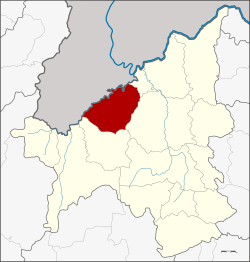 Amphoe location in Loei Province | |
| Coordinates: 17°37′28″N 101°25′17″E / 17.62444°N 101.42139°ECoordinates: 17°37′28″N 101°25′17″E / 17.62444°N 101.42139°E | |
| Country | Thailand |
| Province | Loei |
| Seat | Tha Li |
| Area | |
| • Total | 683.0 km2 (263.7 sq mi) |
| Population (2005) | |
| • Total | 27,117 |
| • Density | 39.7/km2 (103/sq mi) |
| Time zone | ICT (UTC+7) |
| Postal code | 42140 |
| Geocode | 4208 |
Tha Li (Thai: ท่าลี่; IPA: [tʰâː lîː]) is a district (amphoe) in the northwestern part of Loei Province, northeastern Thailand.
Geography
Neighboring districts are (from the northeast clockwise) Chiang Khan, Mueang Loei and Phu Ruea of Loei Province. To the northwest is the Xaignabouli Province of Laos.
The northwestern part of the district reaches the southern end of the Luang Prabang Range mountain area of the Thai highlands.[1]
Administration
The district is divided into six sub-districts (tambon), which are further subdivided into 41 villages (muban). Tha Li is a township (thesaban tambon) which covers parts of the tambon Tha Li. There are a further five tambon administrative organizations (TAO).
| No. | Name | Thai name | Villages | Pop. | |
|---|---|---|---|---|---|
| 1. | Tha Li | ท่าลี่ | 9 | 5,718 | |
| 2. | Nong Phue | หนองผือ | 10 | 7,141 | |
| 3. | A Hi | อาฮี | 6 | 4,646 | |
| 4. | Nam Khaem | น้ำแคม | 6 | 5,004 | |
| 5. | Khok Yai | โคกใหญ่ | 5 | 2,956 | |
| 6. | Nam Thun | น้ำทูน | 5 | 1,652 |
References
- ↑ ดร.กระมล ทองธรรมชาติ และคณะ, สังคมศึกษา ศาสนาและวัฒนธรรม ม.1, สำนักพิมพ์ อักษรเจริญทัศน์ อจท. จำกัด, 2548, หน้า 24-25
External links
This article is issued from Wikipedia - version of the 11/5/2016. The text is available under the Creative Commons Attribution/Share Alike but additional terms may apply for the media files.