Anchor, Shropshire
| Anchor | |
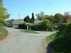 Crossroads in Anchor |
|
 Anchor |
|
| OS grid reference | SO175851 |
|---|---|
| Civil parish | Bettws-y-Crwyn |
| Unitary authority | Shropshire |
| Ceremonial county | Shropshire |
| Region | West Midlands |
| Country | England |
| Sovereign state | United Kingdom |
| Post town | CRAVEN ARMS |
| Postcode district | SY7 |
| Dialling code | 01686 |
| Police | West Mercia |
| Fire | Shropshire |
| Ambulance | West Midlands |
| EU Parliament | West Midlands |
| UK Parliament | Ludlow |
|
|
Coordinates: 52°27′25″N 3°12′54″W / 52.457°N 3.215°W
Anchor is a remote hamlet in southwest Shropshire, England. The hamlet is the most westerly place in Shropshire.
Geography
Anchor lies only 400 metres away from the border with Wales. The B4368 road runs through the hamlet on its way between the towns of Clun (in England) to Newtown (in Wales). The road reaches an elevation of 389 metres (1,276 ft), making it the highest classified road in Shropshire. The point at which the B4368 crosses over the Nant Rhuddwr (a small watercourse that runs along this part of the English-Welsh border; also known as the Rhuddwr Brook in English) into Wales is known as Anchor Bridge. Anchor is also the most westerly settlement in England on the English-Welsh border, with the most westerly point of the border being approximately 1.5 miles to the southwest. The tri-point of Shropshire, Montgomeryshire and Radnorshire is near this most westerly point, located at the confluence of the Nant Rhydyfedw and the Nant Rhuddwr.
Anchor is on the western fringes of the Clun Forest and to the north and northwest lies the forestry plantation of Ceri Forest. The River Clun, which flows towards Newcastle-on-Clun and on to the River Teme near Leintwardine, has its source just south of the hamlet, between Anchor and Bettws Hill Wood, in the marshy area near the pub. The hamlet lies at a saddle point, at the head of the Clun valley on one side and also alongside the Rhuddwr valley on the other side.
Anchor lies in the parish of Bettws-y-Crwyn and the Shropshire Council electoral division of Clun.
Demographics
Two new houses were constructed in the early 2010s near the Anchor Inn, increasing the size of the settlement somewhat.
Features and attractions
At the main crossroads is the "Anchor" public house[1][2] at 386 metres (1,266 ft), the highest pub in Shropshire.[3] It has been a pub continuously since at least 1830 and features in the Mary Webb novel Seven For A Secret (1922) as the "Mermaid's Rest".[1] The Anchor has an entry in both the CAMRA Good Beer Guide 2015 and 2016.
There are a number of small, disused quarries in the area. The local economy is mainly agricultural, with sheep and other livestock farms. There is an Anchor Horse Fair held in the area, usually annually.
Static caravans, camping and stabling for horses are available at The Anchorage, just to the south of the Anchor pub.[4]
Nearby, to the southwest, is Bryn Amlwg Castle, the remains of an ancient castle.
References
- 1 2 CAMRA What Pub Anchor, Anchor
- ↑ Beerintheevening Anchor
- ↑ Shropshire pub survey Anchor
- ↑ Welsh Border Country Holidays - The Anchorage
External links
![]() Media related to Anchor, Shropshire at Wikimedia Commons
Media related to Anchor, Shropshire at Wikimedia Commons
| Unitary authorities | |
|---|---|
| Major settlements | |
| Rivers | |
| Canals | |
| Topics | |