Andin
| Andin | |
|---|---|
 Andin Location in Burma | |
| Coordinates: 15°21′N 97°46′E / 15.350°N 97.767°ECoordinates: 15°21′N 97°46′E / 15.350°N 97.767°E | |
| Country |
|
| State | Mon State |
| Township | Ye Township |
| Elevation | 16 ft (5 m) |
| Population (2005) | |
| • Religions | Buddhism |
| Time zone | UTC + 6:30 (UTC+6.30) |
Andin is a village in Ye Township in the Mon State of south-east Burma. It is located approximately 16 kilometres north-west of Ye city.
Nearby towns and villages include Daminzeik Auk (12.1 nm), Hnyigarok (1.0 nm), Thingangyun (2.2 nm), Awainggale (3.5 nm), Zuntalin (4.0 nm), Daminzeikkyi(8.0 nm), Duya(5.1 nm), Zayat (3.2 nm) and Hnyihnu (2.2 nm).
References
External links
Capital: Mawlamyine | ||
| Mawlamyine District | 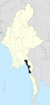 | |
| Thaton District | ||
| Cities and towns | ||
This article is issued from Wikipedia - version of the 10/12/2016. The text is available under the Creative Commons Attribution/Share Alike but additional terms may apply for the media files.