Anglards-de-Salers
| Anglards-de-Salers | ||
|---|---|---|
|
The church of Saint-Thyrse, in Anglards-de-Salers | ||
| ||
 Anglards-de-Salers | ||
|
Location within Auvergne-Rhône-Alpes region  Anglards-de-Salers | ||
| Coordinates: 45°12′20″N 2°26′27″E / 45.2056°N 2.4408°ECoordinates: 45°12′20″N 2°26′27″E / 45.2056°N 2.4408°E | ||
| Country | France | |
| Region | Auvergne-Rhône-Alpes | |
| Department | Cantal | |
| Arrondissement | Mauriac | |
| Canton | Salers | |
| Intercommunality | Pays de Salers | |
| Government | ||
| • Mayor (1995–2020) | François Descoeur | |
| Area1 | 48.36 km2 (18.67 sq mi) | |
| Population (2009)2 | 799 | |
| • Density | 17/km2 (43/sq mi) | |
| Time zone | CET (UTC+1) | |
| • Summer (DST) | CEST (UTC+2) | |
| INSEE/Postal code | 15006 / 15380 | |
| Elevation |
530–1,317 m (1,739–4,321 ft) (avg. 825 m or 2,707 ft) | |
|
1 French Land Register data, which excludes lakes, ponds, glaciers > 1 km² (0.386 sq mi or 247 acres) and river estuaries. 2 Population without double counting: residents of multiple communes (e.g., students and military personnel) only counted once. | ||

Anglards-de-Salers is a French commune in the Cantal department in the Auvergne region of south-central France.
The inhabitants of the commune are known as Anglardois or Anglardoises[1]
Geography
Anglards-de-Salers is located some 60 km west by north-west of Saint-Flour and 15 km south of Ydes. It can be accessed by the D122 road from Mauriac in the west to the village. There is also the minor D22 road from Méallet in the north to the village which continues as a more major road to Salers in the south-east. The D222 road also comes to the village from Salins in the west. The D12 road from Veyrieres in the north also passes inside the north-eastern border of the commune and continues to Le Falgoux to the south-east of the commune. The D212 roads goes west from the D12 to the village. There are a number of small hamlets in the commune. These are:
- Les Aldieres
- Bagnac
- Baliergues
- La Bastide
- Bouisse
- Le Breuil
- Le Caire
- Le Chambon
- Chapsieres
- Epinasolles
- Fignac
- Fournols
- Haut Bagnac
- Joncoux
- Longvergne
- Maleprade
- Montclard
- Noux
- Nuzerolles
- Le Peil
- Pepanie
- Pons
- Pradelles
- Sarrette
- Le Viaureau
- Voleyrac
Other than a belt of forest along the north of the commune, the commune is entirely farmland.
The Mars stream flows through the north of the commune from the east joined by the Ruisseau de Veysset in the north of the commune then continuing north to join the Sumene at Vendes. There is also the Auze stream flowing through the heart of the commune towards the west where it joins the Sione east of Escorailles. The Monzola also flows west in the south joining the Auze just west of the commune. Several other unnamed streams flow into these streams.[2]
Neighbouring communes and villages[2]
 |
Jaleyrac | Méallet | Moussages | |
| Mauriac | |
Cheylade | ||
| ||||
| | ||||
| Salins | Saint-Bonnet-de-Salers | Le Falgoux |
History
List of Priests for Anglards-de-Salers
List of Priests
| From | To | Name | Title |
|---|---|---|---|
| 1508 | Jean de Chazettes | Curato Eclesiae parrochialis anglaris | |
| 1919 | 1929 | A. Borne | Priest |
| 1936 | 1941 | Paul Besse | Priest |
(Not all data is known)
Heraldry
 |
The official status of the blazon is to be determined
Blazon: |
Administration
List of Successive Mayors[3]
| From | To | Name | Party | Position |
|---|---|---|---|---|
| 1792 | 1800 | Antoine Faucher | Notary | |
| 1800 | 1803 | Jean Pebrel | ||
| 1803 | 1808 | Antoine Bergeron | ||
| 1808 | 1825 | Jean Antoine Sauvage | ||
| 1825 | 1830 | Jean Rolland | ||
| 1848 | 1860 | Jean-Martin Salsac | ||
| 1904 | 1908 | Justin Mourguy | ||
| 1908 | 1919 | Paul Bergeron | Doctor | |
| 1920 | 1935 | Antoine Serre | ||
| 1935 | 1947 | Joseph Mathieu | Doctor | |
| 1947 | Augustin Chauvet | UDSR | ||
| 1965 | Jean Descoeur | Doctor | ||
| 1995 | 2020 | François Descoeur | Architect |
(Not all data is known)
Demography
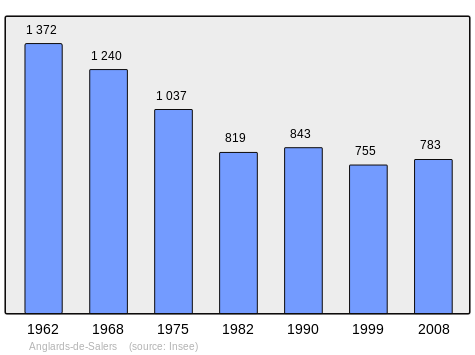
In 2009 the commune had 799 inhabitants. The evolution of the number of inhabitants is known through the population censuses conducted in the commune since 1793. From the 21st century, a census of communes with fewer than 10,000 inhabitants is held every five years, unlike larger towns that have a sample survey every year.[Note 1]
| 1793 | 1800 | 1806 | 1821 | 1831 | 1836 | 1841 | 1846 | 1851 |
|---|---|---|---|---|---|---|---|---|
| 2,139 | 1,942 | 2,107 | 2,821 | 2,402 | 2,438 | 2,266 | 2,551 | 2,336 |
| 1856 | 1861 | 1866 | 1872 | 1876 | 1881 | 1886 | 1891 | 1896 |
|---|---|---|---|---|---|---|---|---|
| 2,270 | 2,236 | 2,390 | 2,256 | 2,307 | 2,224 | 2,233 | 2,391 | 2,235 |
| 1901 | 1906 | 1911 | 1921 | 1926 | 1931 | 1936 | 1946 | 1954 |
|---|---|---|---|---|---|---|---|---|
| 2,033 | 1,962 | 1,988 | 1,831 | 1,663 | 1,626 | 1,566 | 1,541 | 1,460 |
| 1962 | 1968 | 1975 | 1982 | 1990 | 1999 | 2006 | 2009 | - |
|---|---|---|---|---|---|---|---|---|
| 1,372 | 1,240 | 1,037 | 819 | 843 | 755 | 772 | 799 | - |
Sources : Ldh/EHESS/Cassini until 1962, INSEE database from 1968 (population without double counting and municipal population from 2006)
Culture and heritage
Civil heritage
The commune has a number of buildings and structures that are registered as historical monuments:
- The Espradel Garden (19th century)
 [4]
[4] - The Chateau de Longevergne (1905)[5]
- The Château de la Trémolière (15th century)[6] The chateau houses a collection of Aubusson tapestries from the 16th century called the "bestiaire fantastique" (fantastic bestiary). The Chateau contains two items that are registered as historical objects:
- The Montbrun Garden[9]
- Other sites of interest
- The Deduit Orchard is a creation by landscapers Ossart and Maurières:[10] a contemporary medieval garden inspired by the Roman de la rose and the bestiaire fantastique collection.
- Walking trails in the mountain pastures with a plan table
- Robert Besogne Stadium is a football stadium hosting the EAS (Entente Anglards Salers)
Religious heritage
- The Church of Saint-Thyrse (12th century) is registered as an historical monument.[11] The Church contains two items that are registered as historical objects:
Notable people linked to the commune
- Paul Malassagne, Senator for Cantal, was born at Nuzerolles
See also
External links
- Anglards-de-Salers on the National Geographic Institute website (French)
- Anglards-de-Salers on Lion1906
- Anglards-de-Salers on Google Maps
- Anglards-de-Salers on Géoportail, National Geographic Institute (IGN) website (French)
- Anglars on the 1750 Cassini Map
- Anglards-de-Salers on the INSEE website (French)
- INSEE (French)
Notes and references
Notes
- ↑ At the beginning of the 21st century, the methods of identification have been modified by law No. 2002-276 of 27 February 2002 , the so-called "law of local democracy" and in particular Title V "census operations" which allow, after a transitional period running from 2004 to 2008, the annual publication of the legal population of the different French administrative districts. For communes with a population greater than 10,000 inhabitants, a sample survey is conducted annually, the entire territory of these communes is taken into account at the end of the period of five years. The first "legal population" after 1999 under this new law came into force on 1 January 2009 and was based on the census of 2006.
References
- ↑ Inhabitants of Cantal (French)
- 1 2 Google Maps
- ↑ List of Mayors of France
- ↑ Ministry of Culture, Mérimée IA15000332 Espradel Garden (French)
- ↑ Ministry of Culture, Mérimée PA15000015 Chateau de Longevergne (French)
- ↑ Ministry of Culture, Mérimée PA00093438 Château de la Trémolière (French)

- ↑ Ministry of Culture, Palissy PM15000046 4 sets of Wood Panelling (French)
- ↑ Ministry of Culture, Palissy PM15000044 11 Tapestries (French)
- ↑ Ministry of Culture, Mérimée IA15000387 Montbrun Garden (French)
- ↑ Deduit Orchard Official website (French)
- ↑ Ministry of Culture, Mérimée PA00093439 Church of Saint-Thyrse (French)
- ↑ Ministry of Culture, Palissy PM15000043 Face of the Altar: Descent from the Cross
(French)
- ↑ Ministry of Culture, Palissy PM15000045 Group Sculpture: Virgin of Pity
(French)
| Wikimedia Commons has media related to Anglards-de-Salers. |