Antelope Valley (Millard County)
| Antelope Valley (Millard County) | |
| Valley | |
| Country | United States |
|---|---|
| State | Utah |
| Region | (eastern)-Great Basin |
| District | Millard County |
| Borders on | Burbank Hills-NW Ferguson Desert-NE Tunnel Springs Mountains-SE Desert Range Experimental Station-SE Mountain Home Range-SW |
| Parts | Mormon Gap Reservoir |
| City | Garrison, UT |
| Landmarks | Ferguson Desert, Sevier Lake |
| Coordinates | 38°43′27″N 113°55′22″W / 38.72412°N 113.92276°WCoordinates: 38°43′27″N 113°55′22″W / 38.72412°N 113.92276°W |
| Length | 25 mi (40 km), SW-NE [1] |
| Width | 7 mi (11 km) |
 Antelope Valley (Millard County)
in Utah | |
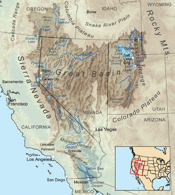
The Antelope Valley of southwest Millard County, Utah is a small 25-mile (40 km) long[1] valley, adjacent the Ferguson Desert and 40 miles (64 km) southwest of Sevier Lake. The valley is just east of the Nevada border, with Snake Valley and the Burbank Hills. The other Antelope Valley of Utah occurs 165 miles (266 km) east in the Great Basin, in southeast Emery County and extending into adjacent Wayne County.
The Desert Biosphere Reserve forms the entire southeast, central & south valley border, where the small, low elevation arid Tunnel Springs Mountains are located.[2]
Description
The Antelope Valley is southwest-northeast trending with a drainage northeast into the Ferguson Desert area. The valley also drains from the northeast flank of the Mountain Home Range adjacent the Nevada border to the southwest. The valley is narrow, only about 7 miles (11 km), at its widest.
Access
Utah State Route 21 transects the upper region of the valley at the alluvial fans of the Mountain Home Range. Route 21 crossing the valley is a NNW trending section, coming from Frisco and Milford, Utah to the town site closest to the valley, Garrison, Utah, northwest of Antelope Valley, and on the Utah-Nevada state line.
See also
References
Great Basin watersheds | ||
|---|---|---|
|  | |