Apple Pie Hill
| Apple Pie Hill | |
|---|---|
 Summit of Apple Pie Hill | |
| Highest point | |
| Elevation | 205 ft (62 m) |
| Coordinates | 39°48′26″N 74°35′22″W / 39.80722°N 74.58944°WCoordinates: 39°48′26″N 74°35′22″W / 39.80722°N 74.58944°W [1] |
| Geography | |
 Apple Pie Hill Location of Apple Pie Hill in New Jersey | |
| Location | Wharton State Forest, Tabernacle Township, Burlington County, New Jersey, U.S. |
| Topo map | USGS Chatsworth [1] |
| Climbing | |
| Easiest route | Batona Trail (hike) |
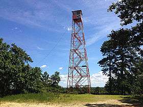
Apple Pie Hill is a hill in Tabernacle Township, Burlington County, New Jersey, United States. It is 205 feet (62 m) tall, making it one of the highest points of the New Jersey Pine Barrens.[2] A 60-foot-tall (18 m) fire tower stands atop the summit.[3] It lies along the Batona Trail in Wharton State Forest, making it a popular hiking destination. On September 10th, 2016, The Department of Environmental Protection closed Apple Pie Hill to public access by erecting a fence around the tower. [4]
Soils are sandy almost everywhere, with profiles that resemble classic podzol development; Atsion, Lakehurst, Lakewood, and Woodmansie are common soil series.[5]

View from the fire tower atop Apple Pie Hill
References
- 1 2 "Apple Pie Hill". Geographic Names Information System. United States Geological Survey. 1979-09-08. Retrieved 2014-09-17.
- ↑ "New Jersey Birding and Wildlife Trails - Wharton State Forest - Apple Pie Hill". Retrieved September 17, 2014.
- ↑ "Apple Pie Hill". SummitPost.org.
- ↑ Pine Barrens landmark off limits to public due to vandalism NJ.com, Accessed October 18, 2016.
- ↑ http://casoilresource.lawr.ucdavis.edu/gmap/
| Wikimedia Commons has media related to Apple Pie Hill (New Jersey). |
This article is issued from Wikipedia - version of the 10/18/2016. The text is available under the Creative Commons Attribution/Share Alike but additional terms may apply for the media files.