Araçoiaba da Serra
| Araçoiaba da Serra | |
|---|---|
| Municipality | |
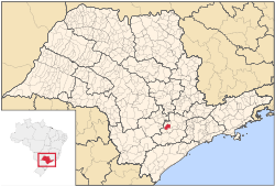 Location in São Paulo state | |
 Araçoiaba da Serra Location in Brazil | |
| Coordinates: 23°30′19″S 47°36′51″W / 23.50528°S 47.61417°WCoordinates: 23°30′19″S 47°36′51″W / 23.50528°S 47.61417°W | |
| Country |
|
| Region | Southeast Brazil |
| State | São Paulo |
| Metropolitan Region | Sorocaba |
| Area | |
| • Total | 255.33 km2 (98.58 sq mi) |
| Elevation | 625 m (2,051 ft) |
| Population (2015) | |
| • Total | 31,321 |
| • Density | 120/km2 (320/sq mi) |
| Time zone | BRT (UTC-3) |
| • Summer (DST) | BRST (UTC-2) |
| Website |
www |
Araçoiaba da Serra is a city in the state of São Paulo in Brazil. It is part of the Metropolitan Region of Sorocaba.[1] The population is 31,321 (2015 est.) in an area of 255.33 km².[2] The elevation is 625 m. The name Araçoiaba comes from the Tupi language, meaning "hider of the sun". This name comes from a single mountain nearby that the natives noted hid the sun as it set in the area.
Population history
| Year | Population |
|---|---|
| 2001 | 19,816 |
| 2004 | 22,521 |
| 2015 | 31,321 |
Demographics
According to the 2000 IBGE Census, the population was 19,816, of which 13,679 are urban and 6,137 are rural. The average life expectancy was 71.1 years. The literacy rate was at 92.14%.
References
- ↑ "Governo do Estado de São Paulo, Lei Complementar nº 1.241, de 8 de maio de 2014". Archived from the original on 2014-10-18. Retrieved 2015-09-29.
- ↑ Instituto Brasileiro de Geografia e Estatística
External links
- (Portuguese) http://www.aracoiaba.sp.gov.br
- (Portuguese) Araçoiaba da Serra on citybrazil.com.br
This article is issued from Wikipedia - version of the 10/17/2016. The text is available under the Creative Commons Attribution/Share Alike but additional terms may apply for the media files.