Arbuckle Mountains
| Arbuckle Mountains | |
|---|---|
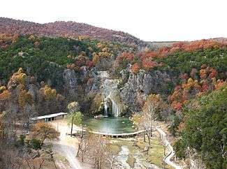 Turner Falls, nestled in the Arbuckle Mountains of South Central Oklahoma. | |
| Highest point | |
| Elevation | 430 m (1,410 ft) |
| Coordinates | 34°27′24″N 97°15′14″W / 34.45667°N 97.25389°W |
| Dimensions | |
| Area | 1,000 sq mi (2,600 km2) |
| Geography | |
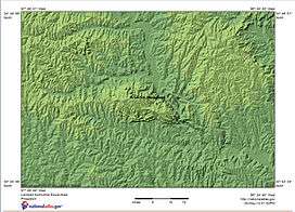 Satellite image with shaded relief map of Arbuckle Mountains in Oklahoma. | |
| Country | United States of America |
| State | Oklahoma |
| Settlement | Cedar Village |
| Range coordinates | 34°26′N 97°11′W / 34.43°N 97.19°WCoordinates: 34°26′N 97°11′W / 34.43°N 97.19°W |
| Geology | |
| Orogeny | Ouachita Orogeny |
| Age of rock | Precambrian, Cambrian, Proterozoic, Pennsylvanian, Permian |
| Type of rock | granite, gneiss, limestone, dolomite, sandstone, shale |

The Arbuckle Mountains are an ancient mountain range in south-central Oklahoma in the United States. They lie in Murray, Carter, Pontotoc, and Johnston counties.[1] The granite rocks of the Arbuckles date back to the Precambrian 'Era' some 1.4 billion years ago which were overlain by rhyolites during the Cambrian Period. The range reaches a height of 1,412 feet above sea level. According to the U.S. Geological Service (USGS):
The Arbuckles contain the most diverse suite of mineral resources in Oklahoma: limestone, dolomite, glass sand, granite, sand and gravel, shale, cement, iron ore, lead, zinc, tar sands, and oil and gas; all these minerals are, or have been, produced commercially.[2]
History
The Arbuckle Mountains are the oldest known formations in the United States between the Appalachian and Rocky Mountains. They contain a core of granite and gneiss that date back at least 1.4 billion years. The core is overlain by a 1,500 feet (460 m) layer of Cambrian-era rhyolite that is about 525 million years old. Atop the rhyolite is about 15,000 feet (4,600 m) of folded and faulted limestones, dolomites, sandstones, and shales deposited in shallow seas from Late Cambrian through Pennsylvanian time (515 - 290 million years ago).[2]
They were named indirectly for Gen. Matthew Arbuckle (1778–1851), a career soldier from Virginia who was active in the Indian Territory for the last thirty years of his life. Shortly before his death at Fort Smith, Arkansas, from cholera, several detachments of troops under his command had established an outpost to protect the California road, on Wildhorse Creek in present-day Garvin County, Oklahoma. The post was then named Fort Arbuckle in his honor. Though the post was abandoned in 1870, the name had already transferred in common usage to the nearby hills.
Geology

Geologically the Arbuckles are an elongate anticline structure with an orientation or strike of west-northwest. The core of the structure consists of Proterozoic extrusive and intrusive rocks, the Colbert rhyolite porphyry and the Tishomingo granite (age dated at 1374 Ma),[3] which are overlain and flanked by early Paleozoic limestones and sandstones that are very steeply dipping to near vertical in orientation. Pennsylvanian to Permian conglomerates were deposited after the orogenic buckling had uplifted and deformed the older strata.
The west trending structure of the Arbuckles and the parallel trending Wichita Mountains is at almost right angle to the regional tectonic trend of the mid-Paleozoic structure from the Ouachitas south to the Marathon Uplift. The Arbuckles are thought to have originated along a failed rift or aulacogen in the Precambrian basement which was uplifted and folded during the Ouachita Orogeny.
Hydrology and karst features
Underlying the Arbuckle Mountains is the Arbuckle-Simpson aquifer, housing freshwater which emanates at springs to provide the base flows of the Blue River and Honey Creek, which flows over Turner Falls south of Davis.
As a result of the karst topography, standing water is rarely found atop the Arbuckle Mountains, the water seeps through fractures and planes of separation in the limestone bedrock, dissolving the rock to produce a network of caves and solution conduits throughout the limestone formations. Organizations such as the Arbuckle Karst Conservancy and Arbuckle Mountains Grotto of the National Speleological Society actively study the karst features of the Arbuckle Mountains to preserve the biological ecosystems and groundwater resources. The organizations currently maintain databases of more than 1,000 caves and springs in the Arbuckle Mountains.[4] Today the Arbuckles have gradually eroded to their present heights of 300–500 feet above the surrounding terrain or 1300–1400 feet above sea level.
Location and tourism

The range is approximately 35 miles (56 km) east-to-west and 10–15 miles north-to-south. The main part of the range is located in northern Carter County and southern Murray County, approximately 15 miles (24 km) north of Ardmore and 5 miles (8.0 km) south of Davis, Oklahoma on Interstate 35. The eastern flank of the ridge is approximately 5 miles (8.0 km) south of Sulphur on U.S. Highway 177.
Popular recreation areas in the Arbuckle Mountains include Turner Falls Park, the Chickasaw National Recreation Area, one of the most popular national park facilities in the United States, and Lake of the Arbuckles. Turner Falls is located 5 miles (8.0 km) south of Davis, whereas Chickasaw NRA is located in the city of Sulphur.
The area is also the location of several campgrounds, including the YMCA's Camp Classen and the Baptist General Convention of Oklahoma's Falls Creek Baptist Conference Center, which hosts 55,000 campers each summer.
References
- ↑ Splinter, Dale K. and Richard A. Marston. Encyclopedia of Oklahoma History and Culture. "Arbuckle Mountains." Retrieved October 7, 2013.
- 1 2 "America's Volcanic Past: Oklahoma:Arbuckle Mountains."
- ↑ Bickford, M. E. and Richard D. Lewis, U-Pb geochronology of exposed basement rocks in Oklahoma, Geological Society of America Bulletin, 1979;90;540-544
- ↑ Blackwood, K.W., Arbuckle Karst Conservancy projects
- James S. Aber, Arbuckle Mountains, Oklahoma
- Robert W. Allen, 2002, Complex Structural Features of the Ardmore Basin
- USGS America's Volcanic Past: Oklahoma
- Kevin W. Blackwood, 2012, The Arbuckle Karst Conservancy
External links
- Arbuckle Mountains - Video footage of the area and a list of local activities and resources.
- Encyclopedia of Oklahoma History and Culture - Arbuckle Mountains
- Oklahoma Digital Maps: Digital Collections of Oklahoma and Indian Territory