Arkansas Highway 106
| ||||
|---|---|---|---|---|
| Bethesda Road | ||||
 | ||||
| Route information | ||||
| Maintained by AHTD | ||||
| Length: | 12.42 mi[1] (19.99 km) | |||
| Major junctions | ||||
| West end: |
| |||
| East end: |
| |||
| Location | ||||
| Counties: | Independence | |||
| Highway system | ||||
| ||||

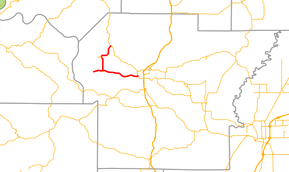
Highway 106 (AR 106, Ark. 106, and Hwy. 106) is an east–west state highway in Independence County. The highway of 12.42 miles (19.99 km) runs from Highway 69 near Cushman south and east to Highway 69B (AR 69B) in Batesville.[2]
Route description
Highway 106 begins at Highway 69 south of Cushman in western Independence County. The highway runs south past the Batesville Livestock and Forestry Research Station, a branch of the University of Arkansas System Division of Agriculture.[3] Highway 106 continues south where Highway 106 Spur begins, running west to Bethesda. The parent route turns east at this point, passing a quarry and Ruddle Hill before entering the Batesville city limits and terminating at Highway 69B.[2]
Major intersections
The entire route is in Independence County.
| Location | mi[1] | km | Destinations | Notes | |
|---|---|---|---|---|---|
| | 0.00 | 0.00 | Eastern terminus | ||
| | 5.66 | 9.11 | AR 106S eastern terminus | ||
| Batesville | 12.42 | 19.99 | Western terminus | ||
| 1.000 mi = 1.609 km; 1.000 km = 0.621 mi | |||||
Bethesda spur
| |
|---|---|
| Location: | Bethesda |
| Length: | 1.62 mi[1] (2.61 km) |
Highway 106 Spur (AR 106S, Ark. 106S, or Hwy. 106S) is a spur route to Bethesda.[2] The highway is 1.62-mile (2.61 km) in length.[1]
- Route description
The route begins at Highway 106 and runs west to Bethesda, a small unincorporated community.
- Major intersections
The entire route is in Independence County.
| Location | mi[1] | km | Destinations | Notes | |
|---|---|---|---|---|---|
| | 0.00 | 0.00 | Eastern terminus | ||
| Bethesda | 1.62 | 2.61 | End state maintenance, roadway continues as Bethesda Ln | Western terminus | |
| 1.000 mi = 1.609 km; 1.000 km = 0.621 mi | |||||
See also
-
 Arkansas portal
 -
 U.S. Roads portal
References
- 1 2 3 4 5 Planning and Research Division (2012). "Arkansas Road Log Database" (MDB). Arkansas State Highway and Transportation Department. Retrieved May 3, 2013.
- 1 2 3 General Highway Map, Independence County, Arkansas (PDF) (Map). 1:62500. Cartography by Planning and Research Division. Arkansas State Highway and Transportation Department. November 3, 2006. Retrieved May 7, 2013.
- ↑ "Batesville Livestock and Forestry Research Station". University of Arkansas System Division of Agriculture. Retrieved May 7, 2013.