Arrondissement of Torcy
| Torcy | |
|---|---|
| Arrondissement of France | |
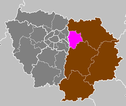 Location of Torcy in Île-de-France | |
| Country | France |
| Region | Île-de-France |
| Department | Seine-et-Marne |
| Communes | 43 |
| Subprefecture | Torcy |
| Area¹ | |
| • Total | 301.8 km2 (116.5 sq mi) |
| Population (2013) | |
| • Total | 418,100 |
| • Density | 1,400/km2 (3,600/sq mi) |
| ¹ French Land Register data, which exclude lakes, ponds, and glaciers larger than 1 km² as well as the estuaries of rivers. | |
The arrondissement of Torcy is an arrondissement of France in the Seine-et-Marne department in the Île-de-France region. It has 43 communes. It was formed in February 1993 from parts of the arrondissements of Meaux (cantons of Claye-Souilly, Lagny-sur-Marne, Torcy, Vaires-sur-Marne, Champs-sur-Marne and Noisiel) and Melun (cantons of Roissy-en-Brie and Pontault-Combault). Until April 1994 it was called arrondissement of Noisiel.[1]
Composition
Cantons
The cantons of the arrondissement of Torcy are:
- Champs-sur-Marne
- Chelles
- Claye-Souilly (partly)
- Lagny-sur-Marne
- Ozoir-la-Ferrière (partly)
- Pontault-Combault
- Serris (partly)
- Torcy
- Villeparisis
Communes
The communes of the arrondissement of Torcy, and their INSEE codes, are:
| 1. Annet-sur-Marne (77005) | 2. Bailly-Romainvilliers (77018) | 3. Brou-sur-Chantereine (77055) |
| 4. Bussy-Saint-Georges (77058) | 5. Bussy-Saint-Martin (77059) | 6. Carnetin (77062) |
| 7. Chalifert (77075) | 8. Champs-sur-Marne (77083) | 9. Chanteloup-en-Brie (77085) |
| 10. Chelles (77108) | 11. Chessy (77111) | 12. Claye-Souilly (77118) |
| 13. Collégien (77121) | 14. Conches-sur-Gondoire (77124) | 15. Coupvray (77132) |
| 16. Courtry (77139) | 17. Croissy-Beaubourg (77146) | 18. Dampmart (77155) |
| 19. Ferrières-en-Brie (77181) | 20. Gouvernes (77209) | 21. Guermantes (77221) |
| 22. Jablines (77234) | 23. Jossigny (77237) | 24. Lagny-sur-Marne (77243) |
| 25. Le Pin (77363) | 26. Lesches (77248) | 27. Lognes (77258) |
| 28. Magny-le-Hongre (77268) | 29. Montévrain (77307) | 30. Noisiel (77337) |
| 31. Ozoir-la-Ferrière (77350) | 32. Pomponne (77372) | 33. Pontault-Combault (77373) |
| 34. Pontcarré (77374) | 35. Roissy-en-Brie (77390) | 36. Saint-Thibault-des-Vignes (77438) |
| 37. Serris (77449) | 38. Thorigny-sur-Marne (77464) | 39. Torcy (77468) |
| 40. Vaires-sur-Marne (77479) | 41. Villeparisis (77514) | 42. Villevaudé (77517) |
| 43. Émerainville (77169) |
References
External links
Coordinates: 48°51′04″N 2°38′59″E / 48.85111°N 2.64972°E
This article is issued from Wikipedia - version of the 5/2/2016. The text is available under the Creative Commons Attribution/Share Alike but additional terms may apply for the media files.