Arrondissement of Toul
| Toul | |
|---|---|
| Arrondissement of France | |
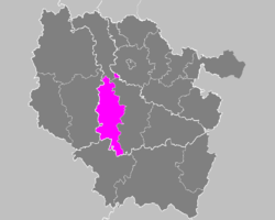 Location of Toul in Lorraine | |
| Country | France |
| Region | Grand Est |
| Department | Meurthe-et-Moselle |
| Communes | 112 |
| Subprefecture | Toul |
| Area¹ | |
| • Total | 1,143 km2 (441 sq mi) |
| Population (2013) | |
| • Total | 69,418 |
| • Density | 61/km2 (160/sq mi) |
| ¹ French Land Register data, which exclude lakes, ponds, and glaciers larger than 1 km² as well as the estuaries of rivers. | |
| Part of the series on |
| Lorraine |
|---|
 Flag of Lorraine since the 13th century |
|
|
Administrative divisions
|
|
Lorraine in the EU |
|
Related topics |
|
The arrondissement of Toul is an arrondissement of France in the Meurthe-et-Moselle department in the Grand Est region. It has 112 communes.
Composition
Cantons
The cantons of the arrondissement of Toul are:
- Meine au Saintois (partly)
- Neuves-Maisons (partly)
- Le Nord-Toulois (partly)
- Pont-à-Mousson (partly)
- Toul
Communes
The communes of the arrondissement of Toul, and their INSEE codes, are:
| 1. Aboncourt (54003) | 2. Aingeray (54007) | 3. Allain (54008) |
| 4. Allamps (54010) | 5. Andilly (54016) | 6. Ansauville (54019) |
| 7. Arnaville (54022) | 8. Avrainville (54034) | 9. Bagneux (54041) |
| 10. Barisey-au-Plain (54046) | 11. Barisey-la-Côte (54047) | 12. Battigny (54052) |
| 13. Bayonville-sur-Mad (54055) | 14. Beaumont (54057) | 15. Bernécourt (54063) |
| 16. Beuvezin (54068) | 17. Bicqueley (54073) | 18. Blénod-lès-Toul (54080) |
| 19. Boucq (54086) | 20. Bouillonville (54087) | 21. Bouvron (54088) |
| 22. Bruley (54102) | 23. Bulligny (54105) | 24. Charey (54119) |
| 25. Charmes-la-Côte (54120) | 26. Chaudeney-sur-Moselle (54122) | 27. Choloy-Ménillot (54128) |
| 28. Colombey-les-Belles (54135) | 29. Courcelles (54140) | 30. Crépey (54143) |
| 31. Crézilles (54146) | 32. Dolcourt (54158) | 33. Domgermain (54162) |
| 34. Dommartin-la-Chaussée (54166) | 35. Dommartin-lès-Toul (54167) | 36. Domèvre-en-Haye (54160) |
| 37. Essey-et-Maizerais (54182) | 38. Euvezin (54187) | 39. Favières (54189) |
| 40. Flirey (54200) | 41. Fontenoy-sur-Moselle (54202) | 42. Foug (54205) |
| 43. Francheville (54208) | 44. Fécocourt (54190) | 45. Germiny (54223) |
| 46. Gibeaumeix (54226) | 47. Gondreville (54232) | 48. Grimonviller (54237) |
| 49. Griscourt (54239) | 50. Grosrouvres (54240) | 51. Gye (54242) |
| 52. Gélaucourt (54218) | 53. Gémonville (54220) | 54. Gézoncourt (54225) |
| 55. Hamonville (54248) | 56. Jaillon (54272) | 57. Jaulny (54275) |
| 58. Lagney (54288) | 59. Laneuveville-derrière-Foug (54298) | 60. Lay-Saint-Remy (54306) |
| 61. Limey-Remenauville (54316) | 62. Lironville (54317) | 63. Liverdun (54318) |
| 64. Lucey (54327) | 65. Mamey (54340) | 66. Mandres-aux-Quatre-Tours (54343) |
| 67. Manoncourt-en-Woëvre (54346) | 68. Manonville (54348) | 69. Martincourt (54355) |
| 70. Minorville (54370) | 71. Mont-l'Étroit (54379) | 72. Mont-le-Vignoble (54380) |
| 73. Moutrot (54392) | 74. Ménil-la-Tour (54360) | 75. Noviant-aux-Prés (54404) |
| 76. Ochey (54405) | 77. Pagney-derrière-Barine (54414) | 78. Pannes (54416) |
| 79. Pierre-la-Treiche (54426) | 80. Pulney (54438) | 81. Rembercourt-sur-Mad (54453) |
| 82. Rogéville (54460) | 83. Rosières-en-Haye (54463) | 84. Royaumeix (54466) |
| 85. Saint-Baussant (54470) | 86. Sanzey (54492) | 87. Saulxerotte (54494) |
| 88. Saulxures-lès-Vannes (54496) | 89. Seicheprey (54499) | 90. Selaincourt (54500) |
| 91. Sexey-aux-Forges (54505) | 92. Sexey-les-Bois (54506) | 93. Thiaucourt-Regniéville (54518) |
| 94. Thuilley-aux-Groseilles (54523) | 95. Toul (54528) | 96. Tramont-Lassus (54530) |
| 97. Tramont-Saint-André (54531) | 98. Tramont-Émy (54529) | 99. Tremblecourt (54532) |
| 100. Trondes (54534) | 101. Uruffe (54538) | 102. Vandelainville (54544) |
| 103. Vandeléville (54545) | 104. Vannes-le-Châtel (54548) | 105. Velaine-en-Haye (54557) |
| 106. Vilcey-sur-Trey (54566) | 107. Villers-en-Haye (54573) | 108. Villey-Saint-Étienne (54584) |
| 109. Villey-le-Sec (54583) | 110. Viéville-en-Haye (54564) | 111. Xammes (54594) |
| 112. Écrouves (54174) |
External links
Coordinates: 48°41′N 5°53′E / 48.683°N 5.883°E
This article is issued from Wikipedia - version of the 11/18/2016. The text is available under the Creative Commons Attribution/Share Alike but additional terms may apply for the media files.