Arthur's Pass (mountain pass)
| Arthur's Pass | |
|---|---|
|
Arthur Dudley Dobson memorial | |
| Elevation | 920 m (3,018 ft) |
| Traversed by | New Zealand State Highway 73 |
| Location | New Zealand |
| Range | Southern Alps |
| Coordinates | 42°54′11.272″S 171°33′42.221″E / 42.90313111°S 171.56172806°E |

Arthur's Pass (el. 920 metres or 3,020 feet) is a mountain pass in the Southern Alps of the South Island of New Zealand. It marks part of the boundary between the West Coast and Canterbury regions, 140 km from Christchurch and 95 km from Greymouth. The pass lies in a saddle between the valleys of the Otira River, a tributary of the Taramakau, in the west and the Bealey River in the east. Arthur's Pass lies on the border of the Selwyn and Westland districts.[1]
A hamlet of the same name (Arthur's Pass) is located about 5 km south of the mountain pass.
History
The pass is named after Sir Arthur Dudley Dobson (1841–1934), who led the first party of Europeans across the pass in 1864. In 1863, Dobson went to the mostly unexplored West Coast of the South Island for seven months of survey work. His area of work extended from the Grey River to Abut Head, and inland up to the Main Divide. His brother Edward, meanwhile, was clearing a rough track over Harper Pass. Arthur Dobson returned to Christchurch and reported his findings to the chief curveyor, Thomas Cass.[2]
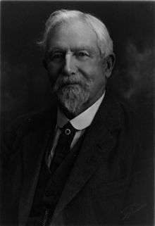
Cass then commissioned Arthur Dobson in 1864 to find out whether there is a suitable pass from the Waimakariri watershed to the West Coast. George and Arthur Dobson set out in March 1864, later to be joined by their brother Edward at Craigieburn. While George surveyed road lines there, Edward and Arthur proceeded to explore the high country. On the advice of West Coast Māori chief Tarapuhi, they found a pass that steeply descended to what became known as Otira; the route had long been used by Māori for trading pounamu. Arthur prepared a report, which included a sketch of the unnamed pass, and presented it to Cass.[3][4]
Soon after, the discovery of gold triggered the West Coast Gold Rush. The provincial engineer, their father Edward Dobson, was commissioned to examine every possible pass to the West Coast from the watersheds of the Waimakariri, Taramakau and Hurunui Rivers. After finishing his examination, he declared that "Arthur's pass" was by far the most suitable to get to the gold fields.[2] The provincial government decided that a road was to be built between Christchurch and Hokitika, a distance of 156 miles (251 km), and Edward Dobson was put in charge of the project.[2] The road was opened on 20 March 1866.[3] The alpine pass became known as Arthur's Pass, with a nearby village and a later a national park also taking this name.[4]
It is also believed that writer and explorer Samuel Butler had seen the pass several years earlier, but was unable to explore it at that time. The timing was perfect, as the West Coast was soon to be hit by a gold rush, and easy access to the Tasman's coast became imperative.
Road link
State Highway 73 passes over Arthur's Pass and is the highest of only three roads crossing the Southern Alps, the other crossings being the Haast Pass and the Lewis Pass. However, Porters Pass, on the same road, is higher (at 939 m) than Arthur's Pass, but it is not considered one of the alpine passes, as it is located in the Canterbury foothills not far away from Springfield.
Previously prone to be blocked by landslides or avalanches, the road on the western side of the pass has seen extensive civil engineering work in the late 1990s. Most notably, the impressive Otira Viaduct, near the settlement of Otira and spanning 440 metres of unstable terrain, was completed in 1999.
Rail link
The Midland Line, connecting Christchurch and the West Coast, crosses the Main Divide by means of the Otira Tunnel, between Arthur's Pass township and Otira. When opened in 1923, the tunnel was the longest in the British Empire.
- Gallery
-
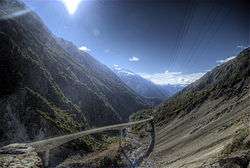
Otira Viaduct
-
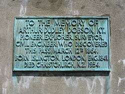
Memorial inscription
-
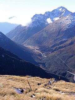
Arthur's Pass
-

Boundary marker
References
- Reed, A. W. (2002). The Reed Dictionary of New Zealand Place Names. Auckland: Reed Books. ISBN 0-7900-0761-4.
- ↑ "Map of the Westland District". Westland District Council.
- 1 2 3 A. H. McLintock, ed. (22 April 2009) [originally published in 1966]. "Dobson Brothers". An Encyclopaedia of New Zealand. Ministry for Culture and Heritage / Te Manatū Taonga. Archived from the original on 12 June 2011. Retrieved 7 May 2011.
- 1 2 Starky, Suzanne. "Dobson, Edward". Dictionary of New Zealand Biography. Ministry for Culture and Heritage. Retrieved 7 May 2011.
- 1 2 "Arthur's Pass 'discovered'". New Zealand Ministry for Culture and Heritage. Archived from the original on 11 June 2011. Retrieved 7 May 2011.
External links
| Wikimedia Commons has media related to Arthur's Pass (mountain pass). |