Arti, Russia
Coordinates: 56°25′N 58°32′E / 56.417°N 58.533°E
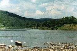
Arti (Russian: Арти) is an urban locality (an urban-type settlement) and the administrative center of Artinsky District of Sverdlovsk Oblast, Russia, located on the Artya River at its confluence with the Ufa River, 203 kilometers (126 mi) southwest of Yekaterinburg and 62 kilometers (39 mi) southeast of Krasnoufimsk. Population: 12,881 (2010 Census);[1] 13,790 (2002 Census);[2] 15,803 (1989 Census);[3] 13,800 (1968).
History
It was founded in 1783 when merchant Lugin built a mechanical plant in the area. During the 19th century the majority of the population was employed by this plant. The plant's products were held in high regard not only in Russia—scythes produced in Arti, for example, received an award at the Paris technical exhibition. In 1917, the plant became one of the first to be nationalized.
Arti is also known for the first Ural Geophysical Station, which was established there in 1870.
In 1918, Arti was a place of an anti-Soviet rebellion, during which many people were killed. After the end of the Russian Civil War, Arti remained the only producer of scythes in the whole country. During the World War II, the plant started to manufacture sewing machines and needles.
Economy
Nowadays Arti is a rapidly developing settlement, where the majority of its economic growth is in the sphere of services.
Unemployment rate is rather low (3.02%). Twenty percent of the unemployed are people with higher education as there is practically no vacant positions for them in Arti at the moment.
References
- ↑ Russian Federal State Statistics Service (2011). "Всероссийская перепись населения 2010 года. Том 1" [2010 All-Russian Population Census, vol. 1]. Всероссийская перепись населения 2010 года (2010 All-Russia Population Census) (in Russian). Federal State Statistics Service. Retrieved June 29, 2012.
- ↑ Russian Federal State Statistics Service (May 21, 2004). "Численность населения России, субъектов Российской Федерации в составе федеральных округов, районов, городских поселений, сельских населённых пунктов – районных центров и сельских населённых пунктов с населением 3 тысячи и более человек" [Population of Russia, Its Federal Districts, Federal Subjects, Districts, Urban Localities, Rural Localities—Administrative Centers, and Rural Localities with Population of Over 3,000] (XLS). Всероссийская перепись населения 2002 года [All-Russia Population Census of 2002] (in Russian). Retrieved August 9, 2014.
- ↑ Demoscope Weekly (1989). "Всесоюзная перепись населения 1989 г. Численность наличного населения союзных и автономных республик, автономных областей и округов, краёв, областей, районов, городских поселений и сёл-райцентров" [All Union Population Census of 1989: Present Population of Union and Autonomous Republics, Autonomous Oblasts and Okrugs, Krais, Oblasts, Districts, Urban Settlements, and Villages Serving as District Administrative Centers]. Всесоюзная перепись населения 1989 года [All-Union Population Census of 1989] (in Russian). Институт демографии Национального исследовательского университета: Высшая школа экономики [Institute of Demography at the National Research University: Higher School of Economics]. Retrieved August 9, 2014.