Arvieu
| Arvieu | ||
|---|---|---|
|
The Lake of Pareloup | ||
| ||
 Arvieu | ||
|
Location within Occitanie region  Arvieu | ||
| Coordinates: 44°11′29″N 2°39′43″E / 44.1914°N 2.6619°ECoordinates: 44°11′29″N 2°39′43″E / 44.1914°N 2.6619°E | ||
| Country | France | |
| Region | Occitanie | |
| Department | Aveyron | |
| Arrondissement | Rodez | |
| Canton | Cassagnes-Bégonhès | |
| Intercommunality | Lévézou Pareloup | |
| Government | ||
| • Mayor (2014–2020) | Gilles Bounhol | |
| Area1 | 46.91 km2 (18.11 sq mi) | |
| Population (2010)2 | 865 | |
| • Density | 18/km2 (48/sq mi) | |
| Time zone | CET (UTC+1) | |
| • Summer (DST) | CEST (UTC+2) | |
| INSEE/Postal code | 12011 / 12120 | |
| Elevation |
606–929 m (1,988–3,048 ft) (avg. 730 m or 2,400 ft) | |
|
1 French Land Register data, which excludes lakes, ponds, glaciers > 1 km² (0.386 sq mi or 247 acres) and river estuaries. 2 Population without double counting: residents of multiple communes (e.g., students and military personnel) only counted once. | ||

Arvieu (Occitan: Arviu) is a French commune in the Aveyron department in the Occitanie region of southern France.
The inhabitants of the commune are known as Arvieunois or Arvieunoises.[1]
Geography
Arvieu is located some 23 km south by south-east of Rodez and 7 km north of Alrance. Access to the commune is by the D56 road from Pont-de-Salars in the north-east passing through the commune and the village and continuing south to Durenque. The D82 branches off the D56 north of the village and goes north to Flavin. The D577 branches off the D56 in the south of the commune and goes west to Salmiech. The commune is entirely farmland except for some small patches of forest.[2]
The eastern border of the commune is the Lac de Pareloup. The Céor river rises in the east of the commune and flows west through the village then south forming part of the western border before continuing west to join the Viaur at Saint-Just-sur-Viaur. The Ruisseau de Glauzeilles rises in the north of the commune flowing west then south-west, forming the north-eastern border of the commune, to join the Céor. The Ruisseau de Calieres rises in the east of the commune and flows north to join the Vioulou just north of the commune.[2]
Places and hamlets[3]
- Les Auglanes
- Aurifeuille
- Beauregard
- Bel-Air
- Bellevue
- Le Besset
- Bois de Nouet
- Bois Grand
- Bonneviale
- Le Bose
- La Brauge
- La Calmette
- Caplongue
- Cayras
- Cayras Bas
- Les Cazals
- Clauzelles
- Clauzellou
- Les Combes
- Le Coutal
- La Croix de l'Ouradou
- Dournets
- Dours
- Espinous
- Espinouset
- Fau du Dours
- Les Faux
- Font Bonne
- Fouleties
- Galinieres
- Gilergues
- Ginestous
- Girman Bas
- Girman Haut
- La Graille
- Grelac
- Lalic
- La Lumiere
- Mas Roux
- Le Mas Roussel
- Le Mas Vayssettes
- Montginoux
- Montredon
- Le Mouli
- Le Moulin d'Aigles
- Le Moulin de la Gineste
- N.-D d'Aures
- Pareloup
- Le Pouget
- La Pendarie
- Pierrefiche
- Pauhle Rouby
- La Pendarie
- La Plane
- Le Puech
- Puech d'Anglas
- Puech Cabane
- Le Puech de Clauzelles
- Puech d'Espinous
- Puech de Girman
- Le Puech Granier
- Puech de Grima
- Puech Grimal
- Le Rhan
- Les Rials
- Rochers du Diable
- le Roucan
- Rougeviale
- Routaboul
- Le Rueillou
- Saint-Martin des Faux (partly in Arvieu and partly in Salles-Curan)
- Serieux
- Les Sottes
- Tredos
- Ventajou
Neighbouring communes and villages[2]
 |
Comps-la-Grand-Ville | Trémouilles | Canet-de-Salars | |
| Salmiech | |
Salles-Curan | ||
| ||||
| | ||||
| Auriac-Lagast | Alrance |
History
- There are traces of the Gallo-Romans
- In the 16th century the village was besieged
- In the 18th century the Vigouroux family of Rodez bought the Lordship
- The Arvieu Affair: The village was attacked by a band of counter-revolutionaries from the former Army of Charrié who hid in the Palanges Forest. The house of Citizen Bonnefous, the leading citizen of the commune, was pillaged. Many people were accused of supporting the attackers who were from the de Barrau family of Carcenac-Salmiech.[4]
- The ramparts were destroyed in the 19th century.
Heraldry
.svg.png) |
Blazon: Party per bend sinister, at 1 Azure with a Cross of Malta of Or; at 2 Gules, a lion Argent. |
Administration
List of Successive Mayors[5]
| From | To | Name | Party | Position |
|---|---|---|---|---|
| 1789 | 1793 | Pierre Lacombe | ||
| 1793 | 1796 | Jean Blancpauly | ||
| 1796 | 1797 | Joseph Dufieu | ||
| 1797 | 1799 | Amans Gaubert | ||
| 1799 | 1801 | François Robert | ||
| 1801 | 1816 | Léonard Bonnefous | ||
| 1816 | 1821 | Pierre Long | ||
| 1821 | 1826 | Léonard Bonnefous | ||
| 1826 | 1830 | Pierre Long | ||
| 1830 | 1843 | Régis Dufieu | ||
| 1843 | 1848 | Léonard Bonnefous | ||
| 1848 | 1851 | Hippolyte Bonnefous | ||
| 1851 | 1854 | Gervais Rigal | ||
| 1854 | 1865 | Jean Cayron | ||
| 1865 | 1879 | Hippolyte Bonnefous | ||
| 1879 | 1892 | Antoine Capron | ||
| 1892 | 1901 | Hippolyte Bonnefous | ||
| 1901 | 1904 | Pierre Salbat | ||
| 1904 | 1913 | Hippolyte Bonnefous | ||
| 1913 | 1929 | Victor Espinasse | ||
| 1929 | 1935 | Hervé Canac | ||
| 1935 | 1941 | Justin Fabie |
- Mayors from 1941
| From | To | Name | Party | Position |
|---|---|---|---|---|
| 1941 | 1945 | Victor Boudes | ||
| 1945 | 1950 | Justin Mai | ||
| 1950 | 1965 | Ernest Thubieres | ||
| 1965 | 1983 | Raymond Almes | ||
| 1983 | 1995 | Léonce Terral | ||
| 1995 | 2008 | Raymond Vaysettes | ||
| 2008 | 2014 | Claudine Bru | ||
| 2014 | 2020 | Gilles Bounhol |
(Not all data is known)
Demography
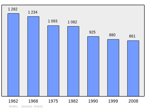
In 2010 the commune had 865 inhabitants. The evolution of the number of inhabitants is known from the population censuses conducted in the commune since 1793. From the 21st century, a census of communes with fewer than 10,000 inhabitants is held every five years, unlike larger towns that have a sample survey every year.[Note 1]
| 1793 | 1800 | 1806 | 1821 | 1831 | 1836 | 1841 | 1846 | 1851 |
|---|---|---|---|---|---|---|---|---|
| 1,247 | 722 | 1,029 | 1,314 | 1,480 | 1,677 | 1,661 | 1,589 | 1,559 |
| 1856 | 1861 | 1866 | 1872 | 1876 | 1881 | 1886 | 1891 | 1896 |
|---|---|---|---|---|---|---|---|---|
| 1,587 | 1,572 | 1,567 | 1,543 | 1,538 | 1,533 | 1,516 | 1,437 | 1,580 |
| 1901 | 1906 | 1911 | 1921 | 1926 | 1931 | 1936 | 1946 | 1954 |
|---|---|---|---|---|---|---|---|---|
| 1,630 | 1,609 | 1,659 | 1,444 | 1,526 | 1,525 | 1,466 | 1,415 | 1,394 |
| 1962 | 1968 | 1975 | 1982 | 1990 | 1999 | 2006 | 2010 | - |
|---|---|---|---|---|---|---|---|---|
| 1,282 | 1,234 | 1,093 | 1,082 | 925 | 880 | - | 865 | - |
Sources : Ldh/EHESS/Cassini until 1962, INSEE database from 1968 (population without double counting and municipal population from 2006)
Culture and heritage
Civil heritage
- A Feudal Château Sainte-Famille (a former convent).
- The Château of Saint-Louis (now the Town Hall).
- The Château of Montfranc (Arvieu, private property).
- A Pond, Mill, and Lavoir (Public laundry) at Arvieu.
Religious heritage

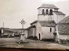
- The Church of Notre-Dame d'Aures (12th centuries)
 is registered as an historical monument.[6] The church contains a Statue of Saint Foy (15th century) which is registered as an historical object.
 [7]
[7] - The Parish Church of Saint-Amans at Arvieu had a Painting: The Assumption of the Virgin (disappeared) (1850) which is registered as an historical object.[8]
- The Church of Saint-Saturnin or Saint-Sernin at Caplongue.
- The Church of Saint-Martin at Faux.
- The Chapel of Saint-André at Clauzelles.
Notable people linked to the commune
- Jean Dupin, (1936-), former senior Post Office official, wrote seven novels set in Lévézou, originally from Arvieu village.
- Joël Serin, former secretary in the Town Hall.
- Henri Grimal, born in Arvieu in 1910, academic and historian.
See also
Bibliography
- Christian-Pierre Bedel, preface by Bernard Destours, Cassanhas: Arviu, Auriac, Caumont, La Grand'Vila, Saumièg, Senta-Jaleda or Christian-Pierre Bedel e los estatjants del canton de Cassanhas, Rodez, Mission départementale de la culture, 1996, Al canton collection, 240 pages, ill., couv. ill., 28 cm, ISBN 2-907279-30-0, ISSN 1151-8375, BnF 366930046 (French)/(Occitan)
External links
- Arvieu official website (French)
- Arvieu tourism website (French)
- Arvieu on the National Geographic Institute website (French)
- Arvieu on Lion1906
- Arvieu on Google Maps
- Arvieu on Géoportail, National Geographic Institute (IGN) website (French)
- Arvieu on the 1750 Cassini Map
- Arvieu on the INSEE website (French)
- INSEE (French)
Notes and references
Notes
- ↑ At the beginning of the 21st century, the methods of identification have been modified by Law No. 2002-276 of 27 February 2002, the so-called "law of local democracy" and in particular Title V "census operations" allows, after a transitional period running from 2004 to 2008, the annual publication of the legal population of the different French administrative districts. For communes with a population greater than 10,000 inhabitants, a sample survey is conducted annually, the entire territory of these communes is taken into account at the end of the period of five years. The first "legal population" after 1999 under this new law came into force on 1 January 2009 and was based on the census of 2006.
References
- ↑ Inhabitants of Aveyron (French)
- 1 2 3 Google Maps
- ↑ Géoportail, IGN, consulted on 4 May 2014 (French)
- ↑ Henri Grimal, The Affair of Arvieu (October 1793), Revue du Rouergue, No. 87, New series, Autumn 2006, pp. 349 to 382. (French)
- ↑ List of Mayors of France (French)
- ↑ Ministry of Culture, Mérimée PA12000030 Church of Notre-Dame d'Aures (French)
- ↑ Ministry of Culture, Palissy PM12000002 Statue: Saint Foy
(French)

- ↑ Ministry of Culture, Palissy IM12000212 Painting: Assumption of the Virgin (French)
| Wikimedia Commons has media related to Arvieu. |