Ashburn, Virginia
| Ashburn, Virginia | |
|---|---|
| Census-designated place | |
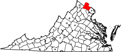
 Ashburn, Virginia Location within the Commonwealth of Virginia | |
| Coordinates: 39°02′37″N 077°29′15″W / 39.04361°N 77.48750°WCoordinates: 39°02′37″N 077°29′15″W / 39.04361°N 77.48750°W[1] | |
| Country |
|
| State |
|
| County |
|
| Area (2010 Census)[2] | |
| • Total | 17.287 sq mi (44.77 km2) |
| • Land | 17.025 sq mi (44.09 km2) |
| • Water | 0.262 sq mi (0.68 km2) |
| Elevation[1] | 295 ft (90 m) |
| Population (2010)[3] | |
| • Total | 43,511 |
| • Density | 2,500/sq mi (970/km2) |
| Time zone | Eastern (EST) (UTC-5) |
| • Summer (DST) | EDT (UTC-4) |
| ZIP codes | 20146, 20147, 20148, 20149 [4] |
| Area code(s) | 703, 571 |
| FIPS code | 51-03320 [2][5] |
| ANSI code | 02584799 [2] |
| GNIS feature ID | 1499063 [5] |
Ashburn is a census-designated place (CDP) in Loudoun County, Virginia. As of the 2010 United States Census, its population was 43,511.[3][6] It is 30 miles (48 km) northwest of Washington, D.C. and part of the Washington metropolitan area.
History
Ashburn was originally called Farmwell (variant names include Old Farmwell and Farmwell Station) after a nearby mansion of that name owned by George Lee III. The name "Farmwell" first appeared in George Lee's October 1802 will and was used to describe the 1,236 acre (5.0 km²) plantation he inherited from his father, Thomas Ludwell Lee II. A section of Farmwell plantation west of Ashburn Road, a 580 acre (2.3 km²) tract, was purchased in 1841 as a summer home by John Janney, a Quaker lawyer who nearly became Vice President of the United States. Janney called the property Ashburn Farm; the name's first known appearance in writing is 1870, when he sold the property. It is likely he named the farm after family friends whose name was "Ashburn".[7]
The Belmont Manor House and Janelia are listed on the National Register of Historic Places.[8]
Geography
Ashburn is located at 39°02′37″N 077°29′15″W / 39.04361°N 77.48750°W (39.0437192, −77.4874899) and its average elevation is 295 feet (90 m) above sea level.[1] According to the 2010 United States Census, the CDP has a total area of 17.287 square miles (44.77 km2), of which 17.025 square miles (44.09 km2) is land and 0.262 square miles (0.68 km2) is water.[2] Ashburn is located between Washington Dulles International Airport and Leesburg, the county seat of Loudoun County.
Subdivisions
The Ashburn area consists of many major and minor subdivisions such as Ashbrook, Ashburn Farm, Ashburn Village, the Courts and Ridges at Ashburn, Belmont Greene, Belmont Country Club, Broadlands and the Village of Waxpool.
Demographics
The United States Census Bureau defines Ashburn as a census-designated place (CDP). As of the 2010 census, the CDP had a population of 43,511 residents,[3] while the larger ZIP Code Tabulation Area (ZCTA) for Ashburn's 20147 ZIP code contained 54,086 people.[9]
Many of its residents commute into Washington, D.C. and the surrounding suburbs such as Tysons Corner and Reston to their places of employment.[10] The median household income as of 2009 was $100,719.[11] Median age in Ashburn is 31.6.[11] Ashburn's population is made up of 49% males and 51% females.[11] The racial makeup of the CDP is White (71%), Asian/Pacific Islander (14%), African American (8%), Hispanic (7%), and Other race (7%).[11] The total number of households accounted for in Ashburn was 22,555.[11] The median household size is 2.9 persons.[11] 98% percent of Ashburn residents have a high school degree.[11] Some 42 percent of Ashburn's population holds a four-year bachelor's degree;[11] 18 percent holds graduate degrees.[11]
Homeowners formed 80 percent of the population.[11] In addition, renters made up 13% of the population.[11] There were 7% properties available as vacancies.[11] The median age of housing was 5.0 years.[11] The median housing value is at $345,000.[12]
Economy
Located within the Dulles Technology Corridor, Ashburn is home to many high-tech businesses. World Trade Center Dulles Airport is currently under construction and will be the second World Trade Center in the state.[13] Verizon Business has a major office in Ashburn at the location replacing MCI WorldCom's headquarters after its acquisition.[14][15] Ashburn is also home to government contractor Telos.
The George Washington University's Virginia Science and Technology Campus and the Howard Hughes Medical Institute's Janelia Research Campus are located in Ashburn. Redskins Park, the training camp for the Washington Redskins football team of the National Football League, is also located in Ashburn.[16] Wikimedia Foundation (parent of Wikipedia) has its primary data center in Ashburn.[17]
EADS North America (the European Aeronautic Defense and Space Company), renamed Airbus Group, Inc., a defense contractor headed by former NASA administrator Sean O'Keefe, has a second location in Ashburn in addition to the main office in Herndon, Virginia.
Government
Federal
The United States Postal Service operates the Ashburn Post Office.[18] The National Transportation Safety Board operates the Ashburn Aviation Field Office in Ashburn; it is the regional headquarters of the NTSB Aviation Eastern Region.[19]
Education
Colleges and universities
George Washington University and Strayer University have campuses in Ashburn. In December 2009, it was announced that George Mason University is planning to set up a campus in Ashburn, to be located at Exit 6 off the Dulles Greenway.[20]
Primary and secondary schools
Educational institutions in Ashburn are operated by the Loudoun County Public Schools.
Ashburn's elementary schools include Ashburn Elementary School, Belmont Station Elementary School, Cedar Lane Elementary School, Discovery Elementary School, Dominion Trail Elementary School, Hillside Elementary School, Legacy Elementary School,Creighton's Corner Elementary, Mill Run Elementary School, Moorefield Station Elementary School, Newton-Lee Elementary School, Rosa Lee Carter Elementary School, Sanders Corner Elementary School, and Steuart W. Weller Elementary School. Ashburn's public middle schools include Eagle Ridge Middle School, Farmwell Station Middle School, Stone Hill Middle School, and Trailside Middle School. Public high schools in Ashburn include Briar Woods High School, Broad Run High School, Stone Bridge High School, Belmont Ridge Middle School, and Rock Ridge High School.[21]
There are five private schools in Ashburn: Ideal Schools High School, St. Theresa Catholic School, Virginia Academy, Boyd School, and County Christian School.
Media
Media covering Ashburn include Leesburg Today, and the Loudoun Times-Mirror.
Infrastructure
Emergency services
Ashburn's fire and emergency medical services are provided by a combination of the volunteers of Ashburn Volunteer Fire-Rescue Department and the Loudoun County Department of Fire, Rescue & Emergency Management. AVFRD is a company under LCFR, and serves Ashburn with Stations 6 and 22, which is located next to Loudoun Hospital. LCFR operates the 24-7 career Moorefield station 23, the first of its kind in the county. The Ashburn area is served by the Inova Ashburn Healthplex Emergency Room at the corner of the Dulles Greenway and Loudoun County Parkway as well as Inova Loudoun Hospital, located less than 2 miles (3.2 km) from Ashburn in neighboring Lansdowne, Virginia, and by larger hospitals in the Washington suburbs and city.
Sports, recreation, and entertainment
Golf courses
Ashburn is home to Brambleton Golf Course, and Belmont Country Club golf courses.
Recreational parks
- Beaverdam Creek Reservoir
- Brambleton Regional Park
- Trailside Park
Sports and entertainment center
One Loudoun, a new multimillion-dollar residential, sports, and entertainment development designed to be the downtown area of Loudoun County, and contains the Alamo Drafthouse Cinema, restaurants, and housing, as well as the Edelman Financial Field, a planned baseball stadium designed to be the centerpiece of the area.[22]
Notable people
See also
- National Register of Historic Places listings in Loudoun County, Virginia
- Janelia mansion, located on Janelia Farm Research Campus
- Belmont Manor House
References
- 1 2 3 "Ashburn". Geographic Names Information System. United States Geological Survey. Retrieved January 21, 2013.
- 1 2 3 4 "Places: Virginia". 2010 Census Gazetteer Files. United States Census Bureau. Retrieved January 21, 2013.
- 1 2 3 "Ashburn CDP, Virginia". Profile of General Population and Housing Characteristics: 2010 Demographic Profile Data. United States Census Bureau. Retrieved January 21, 2013.
- ↑ "Post Office, Zip Code, Jurisdiction and AAA Cross-Reference List" (PDF). Virginia Department for the Aging. June 9, 2004.
- 1 2 "FIPS55 Data: Virginia". FIPS55 Data. United States Geological Survey. February 23, 2006. Archived from the original on June 18, 2006.
- ↑ Virginia Trend Report 2: State and Complete Places (Sub-state 2010 Census Data). Missouri Census Data Center. Accessed 2011-03-08.
- ↑ "Ashburn, VA – History". Retrieved 2013-01-20.
- ↑ National Park Service (2010-07-09). "National Register Information System". National Register of Historic Places. National Park Service.
- ↑ "ZCTA5: 20147 (Ashburn)". Profile of General Population and Housing Characteristics: 2010 Demographic Profile Data. United States Census Bureau. Retrieved January 21, 2013.
- ↑ "Loudoun County Commuter Bus Adds 123 Spaces for Ashburn Commuter Parking". loudouncountytraffic.com. 2010-01-20. Retrieved 2010-07-14.
- 1 2 3 4 5 6 7 8 9 10 11 12 13 "20147 Ashburn Neighborhood in Ashburn, VA". realestate.aol.com. 2010. Retrieved 2012-10-22.
- ↑ "Top-earning towns". CNN. Retrieved August 23, 2012.
- ↑ "World Trade Center: Dulles Airport at One Loudoun". dullesworldtrade.com. 2009. Retrieved 2010-07-14.
- ↑ "Verizon Business Global Llc - Ashburn, Virginia (VA) - Company Profile". manta.com. 2010-06-15. Retrieved 2010-07-14.
- ↑ Noguchi, Yuki (2005-02-15). "Telecom Is Getting Another Behemoth". washingtonpost.com. Retrieved 2010-07-14.
- ↑ "Training Camp Frequently Asked Questions". redskins.com. 2009. Archived from the original on July 23, 2010. Retrieved 2010-07-14.
- ↑ "Wikimedia sites to move to primary data center in Ashburn, Virginia". Wikimedia. January 19, 2013.
- ↑ "Post Office Location - ASHBURN Archived May 16, 2010, at the Wayback Machine.." United States Postal Service. Retrieved on May 15, 2010.
- ↑ "Regional Offices: Aviation." National Transportation Safety Board. Retrieved on May 15, 2010.
- ↑ Kravitz, Derek (2009-12-14). "Developer donates land for George Mason campus in Loudoun". Washington Post. Retrieved 2009-12-19.
- ↑ "Loudoun County Public Schools: Official Website". loudoun.k12.va.us. 2010. Archived from the original on July 22, 2010. Retrieved 2010-07-14.
- ↑ Hoffer, Audrey (10 January 2014). "Buying New: A pedestrian-friendly urban oasis in Loudoun". Washington Post. Retrieved 20 July 2015.
External links
| Wikimedia Commons has media related to Ashburn, Virginia. |
| Wikivoyage has a travel guide for Ashburn (Virginia). |
 |
Leesburg | Poolesville | Potomac | |
| Gleedsville | |
Sterling | ||
| ||||
| | ||||
| Broadlands | Fairfax County | Dulles |