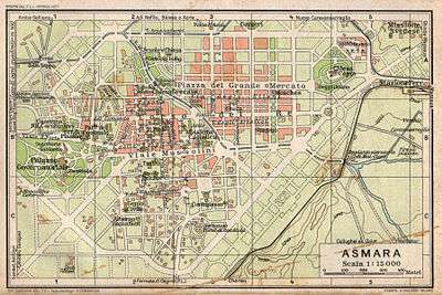
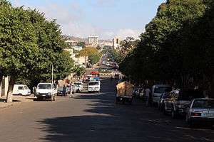
Asmara
| Asmara ኣስመራ Asmera | ||
|---|---|---|
| Capital | ||
 | ||
| ||
| Nickname(s): Piccola Roma, ፒኮላ ሮማ ("Little Rome") | ||
 Asmara | ||
| Coordinates: 15°20′N 38°56′E / 15.333°N 38.933°E | ||
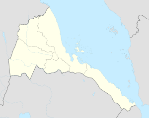
| Country | Eritrea | |
| Region | Maekel | |
| Districts | 13 | |
| Demonym | Asmarino | |
| Government | ||
| • Mayor of Asmara | Semere Russom | |
| • Mayor of Zoba | Tewelde Kelati | |
| Area | ||
| • Capital | 17 sq mi (45 km2) | |
| Elevation | 7,628 ft (2,325 m) | |
| Population (2015)[1] | ||
| • Capital | 804,000 | |
| • Density | 138.3/sq mi (53.38/km2) | |
| • Metro | 1,258,001 | |
| Time zone | EAT (UTC+3) | |
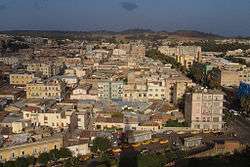
Asmara (Tigrinya: ኣስመራ?, Asmera), known locally as Asmera (meaning "They [feminine plural] made them unite" in Tigrinya), is the capital city and largest settlement in Eritrea. Home to a population of around 805,000 inhabitants,[1] it sits at an elevation of 2,325 metres (7,628 ft). The city is located at the tip of an escarpment that is both the northwestern edge of the Eritrean highlands and the Great Rift Valley in neighbouring Ethiopia.
Asmara is situated in Eritrea's central Maekel Region. It is known for its well-preserved colonial Italian modernist architecture.[2] The city is divided into thirteen districts or administrative areas: Acria, Abbashaul, Edaga Hamus, Arbaete Asmara, Mai Temenai, Paradizo, Sembel, Godaif, Maekel Ketema or Downtown, Tiravolo, Gejeret, Tsetserat and Gheza Banda.
History
Although it would be easy to think of Asmara, the Eritrean capital, solely as an Italian-built colonial city, its origins actually reach back to between 800 BC and 400 BC. The Tigrinya and Tigre people live around there.
Originally, according to Eritrean Tigrinya oral traditional history, there were four clans living in the Asmara area on the Kebessa Plateau: the Gheza Gurtom, the Gheza Shelele, the Gheza Serenser and Gheza Asmae. These towns fought each other until the women of each clan decided that to preserve peace the four clans must unite. The men accepted, hence the name Arbate Asmera. Arbate Asmara literally means, in the Tigrinya language, "the four (feminine plural) made them unite".[3] Eventually Arbate was dropped and it has been called Asmara which means "they [feminine, thus referring to the women] made them unite". There is still a district called Arbaete Asmara in the Administrations of Asmara. It is now called the Italianized version of the word Asmara. The westernized version of the name is used by a majority of non-Eritreans, while the multilingual inhabitants of Eritrea and neighboring peoples remain loyal to the original pronunciation, Asmera.
The missionary Remedius Prutky passed through Asmara in 1751, and described in his memoirs that a church built there by Jesuit priests 130 years before was still intact.[4]
Medri Bahri
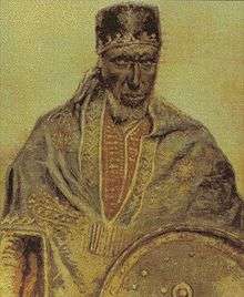
Asmara, which was part of the kingdom of Medri Bahri (later Republic of Hamassien), would briefly come under the occupation of the British-backed and -supported Egyptians. Later Emperor Yohannes IV of Ethiopia briefly occupied the area and gave his trusted Ras Alula the title of governor of Medri Bahri. Alula moved the capital of the kingdom to Asmara, which then had about 150 inhabitants. At this time, the largest city in the Eritrean highlands was Debarwa, now located in the Debub Region. This was the historical capital of the Bahri Negash of Medri Bahri. Within four years, the town's population numbered more than three thousand. Its commercial importance also grew considerably with increased trade with Massawa, which at the time was the largest city in Eritrea.
Italian occupation
Asmara acquired some importance as a result of Alula's choice for the capital of his province, but started to grow in a huge way when it was occupied by Italy in 1889 and was made the capital city of Italian Eritrea in preference to Massawa by Governor Martini in 1897.
In the early 20th century, a railway line was built to the coast, passing through the town of Ghinda, under the direction of Carlo Cavanna. In both 1913 and 1915 the city suffered only slight damage in large earthquakes.[6] In the late 1930s the Italians changed the face of the town, with a new structure and new buildings: Asmara was called Piccola Roma (Little Rome).[7]
While Eritrea was under Italian colonial rule, early-20th-century Europeans used Asmara "to experiment with radical new designs" in architecture[8] Nowadays the major part of buildings are of Italian origin, and shops still have Italian names (e.g., Bar Vittoria, Pasticceria moderna, Casa del formaggio, and Ferramenta).
Asmara was populated by a large Italian community and consequently the city acquired an Italian architectural look. The city of Asmara had a population of 98,000, of which 53,000 were Italian according to the Italian census of 1939. This fact made Asmara the main "Italian town" of the Italian empire in Africa. In all of Eritrea the population of Italians was only 75,000 in total in that year, making Asmara by far their largest centre.[9] Italia Asmara enjoyed a huge development in the 1930s, not only economically but even socially and culturally: Italians even created the theater Asmara's Opera and the car race Circuito Asmara.
Many industrial investments were made by Italy in Asmara (and surrounding areas of Eritrea),[10] but the beginning of World War II stopped the blossoming industrialization of the area.
British occupation
Italy was defeated in 1941, and the British administered the city and the rest of the country from 1941 to 1952. During this time, many industries were shipped out of the city to other, long-standing British colonies such as India and Kenya. The British maintained initially the Italian administration of Eritrea. Eritrea was joined with Ethiopia in 1952. Asmara was one of the cities (along with Addis Ababa and Gondar) that Queen Elizabeth II of the United Kingdom visited in 1965, at the invitation of the then-Emperor of Ethiopia, Haile Selassie I.
Federation with Ethiopia
In 1952, the United Nations resolved to federate the former colony under Ethiopian rule. During the federation, Asmara was no longer the capital city. The capital was now Addis Ababa, over 1,000 kilometres (620 miles) to the south. The national language of the city was therefore replaced from Tigrinya language to the Ethiopian Amharic language. In 1961, emperor Haile Selassie I ended the "federal" arrangement and declared the territory to be the 14th province of the Ethiopian Empire.[11] Ethiopia's biggest ally was the United States. The city was home to the US Army's Kagnew Station installation from 1943 until 1977. The Eritrean War of Independence began in 1961 and ended in 1991, resulting in the independence of Eritrea. Asmara was left relatively undamaged throughout the war, as were the majority of highland regions. After independence, Asmara, again became the capital of Eritrea.
Demographics
Asmara's population of around 1,258,001 residents makes it the largest city in Eritrea. Although all ethnic groups are represented in the capital, the largest groups are the Tigrinya people (77%) and the Tigre people (15%). In Asmara, the main language is Tigrinya. Arabic, Italian and English are also widely spoken and understood.
The Eritrean government's 2003 national census found 99.67% of Asmara's housing units had access to safe drinking water, 96.9% had flush toilets, 2.1% pit toilets (both ventilated and unventilated), and 1% had no toilet facilities. Adult literacy for men is 95.2% and for women 89.95%, the highest in the nation for both sexes.
Religion
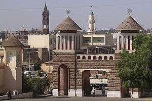
Asmara is very diverse when it comes to religion. Three big landmarks of the city are the St Joseph's Cathedral, Asmara of the Catholic faith, the Enda Mariam Coptic Cathedral of the Eritrean Orthodox Tewahedo Church and the Al Khulafa Al Rashiudin Mosque of the Islamic faith. Christians and Muslims have lived peacefully together in Asmara for centuries. The religion with the most believers in Asmara is the Eritrean Orthodox Tewahedo Church (60%), Catholicism (21%) and Sunni Islam (19%). The towns and villages surrounding the city in the highlands are predominantly Christian (most places being all Christian). Further towards the lowlands, a few Muslim towns and villages are found. The Asmara Synagogue is the last piece of physical evidence of the Jewish community that once resided in Eritrea.[12]
Italian Eritreans
The city has a significant population of Italian Eritreans. These are Eritrean-born descendants of Italian settlers as well as Italian long-term residents in Eritrea. Those born of mixed race unions are called 'hanfets'. Their ancestry dates back from the beginning of the Italian colonization of Eritrea at the end of the 19th century, but only after the Second Italo-Abyssinian War of 1935 they settled in large numbers. In the 1939 census of Eritrea there were more than 75,000 Eritrean Italians (over 10% of the Eritrean population then), most of them (53,000) living in Asmara. Many Italian settlers got out of their colony after its conquest by the Allies in November 1941 and they were reduced to only 38,000 by 1946. Although many of the remaining Italians stayed during the decolonization process after World War II and are actually assimilated to the Eritrean society, a few are stateless today, as none of them were given citizenship unless through marriage or, more rarely, by having it conferred upon them by the State.
| year | Italian Eritreans | Eritrea population | Asmara population | |||
|---|---|---|---|---|---|---|
| 1910 | 1,000 | 390,000 | 24,000 | |||
| 1935 | 3,100 | 610,000 | 47,000 | |||
| 1939 | 76,000 | 740,000 | 103,000 | |||
| 1946 | 38,000 | 870,000 | 88,000 | |||
| 2008 | 900 | 4,500,000 | 610,000 | |||
| The Italian Eritrean population in Eritrea, from 1910 to 2008 | ||||||
Today there are approximately 900 Italian Eritreans remaining in the Asmara region. However, there are an estimated 100,000 descendants of Italian Eritreans out of the 600,000 population of the city of Asmara.
Geography
The city lies at an elevation of 2,325 metres (7,628 feet) above sea level. It lies on north-south trending highlands known as the Eritrean Highlands, an extension of the Ethiopian Highlands. The temperate central portion, where Asmara lies, is situated on a rocky highland plateau, which separates the western lowlands from the eastern coastal plains. The lands that surround Asmara are very fertile, especially those to the south towards the Debub Region of Eritrea. The highlands that Asmara is located in fall away to reveal the eastern lowlands, characterised by the searing heat and humidity of the Eritrean salt pans, lapped by the Red Sea. To the west of the plateau stretches a vast semi-arid hilly terrain continuing all the way towards the border with Sudan through the Gash-Barka Region.
Climate
Asmara features a somewhat rare version of a steppe climate, with warm, but not hot summers and mild winters. Asmara's climate can also be considered arid to semi-arid.[13] Due to its 2,325 metres (7,630 ft) altitude, temperatures are relatively mild for a city located not particularly far from deserts. This climate is characteristic of rainy, wet seasons and dry seasons.[14] Asmara averages about 500 millimetres (20 in) of precipitation annually. Frost, however, is extremely rare in the city. The long rainy season of the year extends from June until September. The short rainy season occurs from March until April.[14] On average, about 60% of Asmara’s annual precipitation is seen during the months of July and August. In contrast, December to February are typically Asmara’s driest months, where on average only 8 millimetres (0.31 in) of precipitation falls in the three months combined. Due to variable rainfall, Asmara’s climate is also characterized by drought.[15] Several prolonged droughts in this region have occurred beginning in the 1960s and have recurred each decade since then.[15] During periods of drought, temperatures are high and little rainfall occurs. As temperatures of a region increase, the rate of evaporation of water from the soil also increases. These combined processes result in the desertification of the soil. In order to obtain nutrient rich and moist soil, populations rely on deforestation. The removal of forests from the soil allows for the soil to be put to other use.[15] The most serious environmental issues Asmara faces are deforestation and desertification. Other issues Asmara faces are soil erosion and overgrazing. All of these environmental issues produce soil degradation.[15]
| Climate data for Asmara (1961–1990, extremes 1903–2012) | |||||||||||||
|---|---|---|---|---|---|---|---|---|---|---|---|---|---|
| Month | Jan | Feb | Mar | Apr | May | Jun | Jul | Aug | Sep | Oct | Nov | Dec | Year |
| Record high °C (°F) | 29.0 (84.2) |
29.2 (84.6) |
30.5 (86.9) |
31.0 (87.8) |
30.0 (86) |
29.4 (84.9) |
29.4 (84.9) |
27.4 (81.3) |
27.2 (81) |
31.0 (87.8) |
26.7 (80.1) |
26.2 (79.2) |
31.0 (87.8) |
| Average high °C (°F) | 22.3 (72.1) |
23.8 (74.8) |
25.1 (77.2) |
25.1 (77.2) |
25.0 (77) |
24.9 (76.8) |
21.6 (70.9) |
21.5 (70.7) |
22.9 (73.2) |
21.7 (71.1) |
21.5 (70.7) |
21.5 (70.7) |
23.1 (73.6) |
| Daily mean °C (°F) | 13.8 (56.8) |
14.9 (58.8) |
16.3 (61.3) |
17.0 (62.6) |
17.6 (63.7) |
17.6 (63.7) |
16.3 (61.3) |
16.1 (61) |
15.7 (60.3) |
14.9 (58.8) |
14.0 (57.2) |
13.2 (55.8) |
15.6 (60.1) |
| Average low °C (°F) | 4.3 (39.7) |
5.1 (41.2) |
7.5 (45.5) |
8.7 (47.7) |
10.2 (50.4) |
10.5 (50.9) |
10.8 (51.4) |
10.7 (51.3) |
8.6 (47.5) |
8.1 (46.6) |
6.6 (43.9) |
4.8 (40.6) |
8.0 (46.4) |
| Record low °C (°F) | −4.5 (23.9) |
−1.6 (29.1) |
−0.8 (30.6) |
−0.2 (31.6) |
2.0 (35.6) |
3.4 (38.1) |
3.9 (39) |
3.7 (38.7) |
0.2 (32.4) |
1.0 (33.8) |
−0.5 (31.1) |
−1.4 (29.5) |
−4.5 (23.9) |
| Average precipitation mm (inches) | 3.7 (0.146) |
2.0 (0.079) |
14.6 (0.575) |
33.4 (1.315) |
41.1 (1.618) |
38.5 (1.516) |
174.9 (6.886) |
155.6 (6.126) |
15.6 (0.614) |
15.4 (0.606) |
20.4 (0.803) |
3.4 (0.134) |
518.6 (20.417) |
| Average precipitation days (≥ 1.0 mm) | 0 | 0 | 2 | 4 | 5 | 4 | 13 | 12 | 2 | 2 | 2 | 1 | 47 |
| Average relative humidity (%) | 54 | 48 | 46 | 49 | 48 | 48 | 76 | 80 | 59 | 63 | 66 | 61 | 58.2 |
| Mean monthly sunshine hours | 291.4 | 260.4 | 275.9 | 264.0 | 257.3 | 219.0 | 151.9 | 158.1 | 213.0 | 272.8 | 276.0 | 282.1 | 2,921.9 |
| Mean daily sunshine hours | 9.4 | 9.3 | 8.9 | 8.8 | 8.3 | 7.3 | 4.9 | 5.1 | 7.1 | 8.8 | 9.2 | 9.1 | 8.02 |
| Source #1: NOAA[16] | |||||||||||||
| Source #2: Meteo Climat (record highs and lows)[17] | |||||||||||||
Architecture
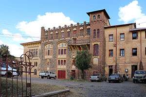
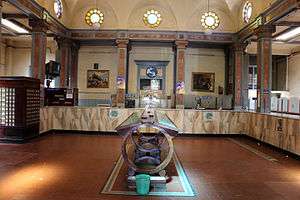
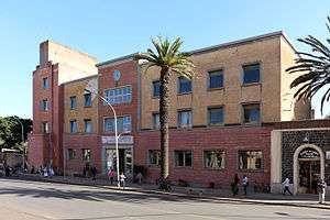
Asmara has perhaps one of the most concentrated and intact assemblage of Modernist architecture anywhere in the world. The urban design within the Historic Perimeter has remained untouched since its original implementation and subsequent evolution throughout the 1930s, and the architectural elements exemplify a superlative example of Modernist architecture in a complete urban setting. The city's architecture is heavily influenced by Italian architecture. Asmara is the site of an ancient highland village called 'Arbate Asmara'. In 1885, the Italians invaded Eritrea and by 1900, Asmara had become the capital city. The site was chosen for its salubrious highland climate, reliable water supply and ideal geographic location in the centre of Eritrea. In the early twentieth century, Asmara represented little more than a tiny highland village, which grew incrementally to become a well-established town by the 1920s.
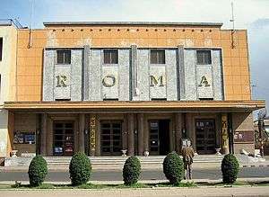
However, by the 1930s, it was clear that Italy, under the rule of Mussolini, was intent on invading neighbouring Ethiopia and would use Eritrea as the launch pad for this long-held ambition. In preparation for this substantial military escapade, an unprecedented quantity of materials and labour flowed into Eritrea throughout the 1930s. In a matter of months, Asmara became a vast building site, as over 70,000 Italians arrived to establish new lives for themselves. The rapid transformation of Asmara from a relatively minor town into Africa's most modern and sophisticated city at that time overlapped with equally momentous events in the world of design and architecture, which involved the global proliferation of Modernism and its various forms, including Futurism, Rationalism, Novecento, and Art Deco. The spirit of this new age of travel and adventure was embodied in these new architectural forms. Asmara was an ideal blank canvas on which Italian architects could practice and realise these modern ideals. From 1935 to 1941, thousands of buildings were constructed in the city, most of which reflect various Modernist styles and some of which represent inimitable architectural forms, such as petrol stations mimicking aeroplanes and boats, commercial buildings designed as trains, cavernous cinemas with fine period plasterwork and Art Dem interiors, fine ultra-modern hotels and offices, and government buildings with highly politicised monumental designs.
Since 2011 , Asmara is building skyscrapers in the urban areas were there is the most modernization.
Features
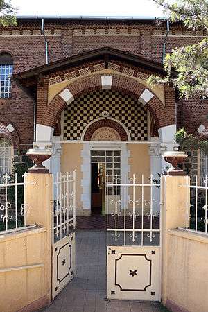
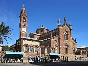
The city is home to the Eritrean National Museum and is known for its early 20th-century buildings, including the Art Deco Cinema Impero (opened in 1937 and considered by the experts one of the world's finest examples of Art Déco style building[18]), Cubist Africa Pension, eclectic Orthodox Cathedral and former Opera House, the futurist Fiat Tagliero Building, neo-Romanesque Roman Catholic Cathedral, and the neoclassical Governor's Palace. The city is adorned by Italian colonial villas and mansions, one prominent example being the World Bank Building. Most of central Asmara was built between 1935 and 1941, so effectively the Italians managed to build almost an entire city, in just six years.[19] At this time, the dictator Benito Mussolini had great plans for a second Roman Empire in Africa. War cut this short, but his injection of funds created the Asmara of today, which supposedly was to be a symbol that Fascism worked and is an ideal system of government.
The city shows off most early 20th-century architectural styles. Some buildings are neo-Romanesque, such as the Roman Catholic Cathedral, some villas are built in a late Victorian style. Art Deco influences are found throughout the city; essentially Asmara was then what Dubai is now. Architects were restricted by nothing more than the bounds of their imaginations and were given the funds to create masterpieces which we can see today. Essences of Cubism can be found on the Africa Pension Building, and on a small collection of buildings. The Fiat Tagliero Building shows almost the height of futurism, just as it was coming into big fashion in Italy. In recent times, some buildings have been functionally built which sometimes can spoil the atmosphere of some cities, but they fit into Asmara as it is such a modern city.
Asmara is also the see of the archbishop of the Eritrean Orthodox Tewahedo Church, which became autocephalous in 1993. The archbishop was elevated in 1998 to the rank of Patriarchate of Eritrea, on a par with the Ethiopian Orthodox Tewahedo Church.
Asmara was known to be an exceptionally modern city, not only because of its architecture, but Asmara also had more traffic lights than Rome did when the city was being built.[19] The city incorporates many features of a planned city. Indeed, Asmara was an early example of an ideal modern city created by architects, an idea which was introduced into many cities across the world, such as Brasilia, but which was not altogether popular. Features include designated city zoning and planning, wide treed boulevards, political areas and districts and space and scope for development. Asmara was not built for the Eritreans however; the Italians built it primarily for themselves. One unfortunate aspect of the city's planning was separate areas designated for Italians and Eritreans, each disproportionately sized.
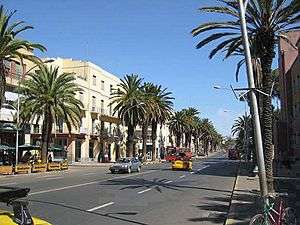
The city has more than 400 examples of Italian-style architecture,[20] wide streets, piazzas and coffee bars. While the boulevards are lined with palms and local shiba'kha trees, there are numerable pizzerias and coffee bars, serving cappucinos and lattes, as well as ice cream parlours and restaurants with Italian eritrean cuisine.[20]
People in Asmara dress in a unique, yet Eritrean style. Asmara is also highly praised for its peaceful, crime-free environment.[21] It is one of the cleanest cities on the continent.
The city hosts the We Are the Future center, a child care center giving children a chance to live their childhoods and develop a sense of hope. The center is managed under the direction of the mayor’s office, and the international NGO Glocal Forum serves as the fundraiser and program planner and coordinator for the WAF child center in each city. Each WAF city is linked to several peer cities and public and private partners to create a unique international coalition.
Asmara has been proposed as a possible new addition to the UNESCO World Heritage Sites,[19] under the direction of the Cultural Assets Rehabilitation Project, for its outstanding examples of 20th-century architecture and town planning. Many of these historic buildings are not currently being taken care of and there is a serious risk that this heritage could be lost.
The Historic Center of Asmara was placed on the World Monuments Fund's 2006 Watch List of 100 Most Endangered Sites. The listing was designed to bring more attention to the city to save the center from decay and redevelopment and to promote restoration.
Following CARP (a World Bank initiative on Cultural Heritage), the European Union Delegation in Asmara has engaged into an Heritage Project pertaining to building's restoration and archive management. Launched in 2010 the EU /Eritrea Cultural Project is expected to be completed in 2014 (Pierre Couté - Edward Denison, Project Design Report, EUD Asmara 2009).
Economy
As the capital city and largest settlement of Eritrea, most Eritrean businesses have their headquarters in Asmara. The city was once a factory town.
During the colonial period, Asmara was an administrative and commercial center of Italian East Africa. When the British entered the country in 1941, many businesses were closed down or relocated outside of the city. This trend continued under Ethiopian occupation.
Nasair[22][23] and the Eritrean Telecommunications Corporation are headquartered in the city.[24] In addition, country's national television station Eri-TV has many studios located in various areas in the capital.
The city of Asmara is a center for agricultural products and tanning hides. The primary industrial products of Asmara are: textiles, clothing, footwear, processed meat, beer, soft drinks, and ceramics.[12]
Transport
Taxis that run in the city of Asmara start at 07:00 and end at 21:00, and can get very crowded at peak times. The fare for a shared taxi is 5-10 Nakfa per seat. A contracted taxi can charge between 20 and 300 Nakfa so the price should be negotiated before entering the taxi. Contracted taxis also run outside Asmara to various other cities, towns and villages including; Massawa, Keren, Mendefera, Dekemhare, Adi Quala, Ghinda and Nefasit. Long distance buses in Eritrea are not crowded because it is illegal for passengers to stand in the aisle. There are organized breakfast and/or lunch stops on longer trips. When traveling to remote places, like Assab, Nakfa, Tesseney or Senafe, reservations should be made for the return trip in advance, to prevent being stranded.
There is a railway station in Asmara that connects the city with Massawa: the Eritrean Railway, built by the Italians between 1887 and 1932, has been recently restructured. Indeed, the line has now been restored from Massawa all the way through to Asmara, but as of 2006 no scheduled services traverse the whole length of the line. The area is served by Asmara International Airport.
The Asmara International Airport is the only airport in Asmara. The airport is very limited in capacity and land extent. The short length of the runways inhibits large aircraft from flying to the Asmara airport, and instead these planes must land at Massawa International Airport, located in the city of Massawa.[12]
After the independence of Eritrea, the roads of Asmara went under construction. The old roads were renovated and new highways were also built. There are only five primary roads out of Asmara:[12] it is one of Africa’s most isolated capitals.[25]
Charter trains for tourists now do, and regular train services exist in certain areas where there is demand. While the surviving equipment is sufficient for such a limited service, the purchase or building of more is necessary to provide a serious form of transportation over the length of the line.
The Eritrean Railroad Authority has requested funding to continue the Italian-era plan to extend the route from Asmara to Tesseney and provide an opportunity for Sudan to efficiently use the Port of Massawa.
Education
Asmara is home to the majority of colleges and universities. The city has always been a national centre of education, and is home to many elementary and high schools. Until the recent opening of universities at Mai Nefhi and Sawa, it was the seat of the only university in the country, the University of Asmara. During the period of Ethiopian federation and annexation, the college was also linked with what was then the nation's largest tertiary institution, Addis Ababa University. Many campuses have been opening up across the country since independence, mainly for medicine and engineering.
University coursework in Eritrea is, for the most part, four years of academic study followed by one year of university national service in a relevant Eritrean Ministry. Once these five years are completed, students are then awarded their degree.
Going beyond secondary education in Eritrea is very rare. Only a small number of students even attend a university to receive their degree. However, people residing in Asmara are more likely to go to college more than people in other parts of the country. Eritrea's Human Resource Development (HRD) planning has had a significant impact on the inner workings of all university study. First, applicants are required to take a matriculation exam before subjects of study are even allocated, then the priorities of students are only given a brief consideration. Dr. Wolde-Ab Yisak, President of the University of Asmara, together with all the other ministries in government, put together a list of what fields are lacking employment. This government prediction forecast then helps officials decide how many students are admitted, along with how many will be assigned in each department of the university. The government officials hope that this plan strategically ensures that in Asmara there is an equal spread of human resources in all fields of work.
So far, this strategy has been rather successful in adding to the country’s human capital. Despite challenges in trying to equally balance human resources, most Eritreans want their career to help further their country’s success. In other words, most accept their university assignment as their social obligation to serve a bigger purpose.[26]
Universities and colleges
- University of Asmara
- Eritrea Institute of Technology
- Asmara institute of religious stuides
Primary and secondary schools
International schools
- Asmara International Community School - Anglophone international school
- Italian School of Asmara - Italian primary school with a Montessori department
- Liceo Sperimentale "G. Marconi" - Italian international senior high school
- Istituto Italiano Statale Comprensivo (IT) - Italian international elementary and junior high school
Districts
Asmara is divided into 13 districts or administrative areas. These districts are subdivided into North, North-West, North-East, South-East, South-West, East, West and Central areas. The thirteen districts (or Neous Zobas) are:
- North
- Acria District
- Abbashaul District
- Edaga Hamus District
- North-East
- Arbaete Asmara District
- North-West
- Mai Temenai District
- Paradiso District
- South-West
- Sembel District
- South-East
- Kahawuta District
- Godaif District
- Central
- Maakel Ketema District
- West
- Gheza Banda District
- Tsetserat District
- East
- Tiravolo District
- Gejeret District
References
- 1 2 "CIA - The World Factbook". Retrieved 2 September 2012.
- ↑ Mark Byrnes An African City's Unusual Preservation Legacy Feb 08, 2012 Atlantic Cities
- ↑ Palin, Michael. Eritrea. Chalfont St Peter, United Kingdom: Bradt Travel Guides Ltd.
- ↑ J.H. Arrowsmith-Brown, translator and editor (1991). Prutky's Travels to Ethiopia and Other Countries. London: Hakluyt Society. p. 78.
- ↑ https://books.google.com/books?id=Qi-KQchGks8C&pg=PA83&lpg=PA83&dq=ras+alula+asmara&source=bl&ots=M1YKOQNaAw&sig=2Em2DJqnV-gOntnch-aReCNg8Ug&hl=en&sa=X&ved=0ahUKEwiZkcHgy9LNAhVHxWMKHVuKBmwQ6AEIVzAL#v=onepage&q=ras%20alula%20asmara&f=false
- ↑ Ambraseys, Nicolas; Melville, C.P.; Adams, R.D. (1994). The Seismicity of Egypt, Arabia and the Red Sea: A Historical Review. Cambridge University Press. ISBN 0-521-39120-2.
- ↑ Italian architectural planification of Asmara (in Italian) p. 64-66
- ↑ "Asmara useful for experimenting with radical designs for Europeans". Washington Times. 15 September 2007. Retrieved 8 December 2010.
- ↑ "Benvenuto sul sito del Maitacli" (in Italian). Archived from the original on 22 July 2011. Retrieved 8 July 2011.
- ↑ Italian Eritrea industries
- ↑ Encyclopedia of Urban Cultures. Grolier Publishing Co. 2002.
- 1 2 3 4 "Asmara - New World Encyclopedia". www.newworldencyclopedia.org. Retrieved 2016-11-14.
- ↑ Semere, Soloman (23 December 2005). "Groundwater study using remote sensing and geographic information systems (GIS) in the central highlands of Eritrea". Hydrogeology Journal. 14 (5): 729–741. doi:10.1007/s10040-005-0477-y.
- 1 2 Semere, Soloman (23 December 2005). "Groundwater study using remote sensing and geographic information systems (GIS) in the central highlands of Eritrea". Hydrogeology Journal. 14 (5): 729–741. doi:10.1007/s10040-005-0477-y.
- 1 2 3 4 Ghebrezgabher, Mihretab (September 7, 2015). "Extracting and analyzing forest and woodland cover change in Eritrea based on landsat data using supervised classification". The Egyptian Journal of Remote Sensing and Space Science. 19 (1): 37–47. doi:10.1016/j.ejrs.2015.09.002.
- ↑ "Asmara Climate Normals 1961–1990". National Oceanic and Atmospheric Administration. Retrieved January 13, 2015.
- ↑ "Station Asmara" (in French). Meteo Climat. Retrieved 22 October 2016.
- ↑ Gianluca Rossi, Renzo Martinelli inviato de La Nazione, 2009.
- 1 2 3 "Reviving Asmara". BBC Radio 3. 19 June 2005. Retrieved 30 August 2006.
- 1 2 Video on "Italian Asmara" in our days (in Italian)
- ↑ http://www.madote.com/2010/11/worlds-safest-city-is-asmara.html
- ↑ "World Airline Directory." Flight International. 23–29 March 2004. 68.
- ↑ "Fly Eritrean Hospitality". Nasair. Archived from the original on 31 May 2011. Retrieved 8 July 2011.
- ↑ Welcome to the Telecommunication Internet Service Provider - TSEiNET, archived from the original on 20 July 2011, retrieved 8 July 2011
- ↑ Stevis, Matina (2015-10-21). "What It's Like Inside Asmara, One of Africa's Most Isolated Capitals". Wall Street Journal. ISSN 0099-9660. Retrieved 2016-11-14.
- ↑ Müller, Tanja R. "'Now I Am Free'--Education And Human Resource Development In Eritrea: Contradictions In The Lives Of Eritrean Women In Higher Education." Compare: A Journal Of Comparative Education 34.2 (2004): 215-229. Academic Search Complete.Web. 8 Nov. 2016.
Further reading
- Stefan Boness: "Asmara - Africa´s Jewel of Modernity". Jovis Verlag, Berlin 2016, ISBN 978-3-86859-435-5 (photo book; German, English)
- Stefan Boness: "Asmara - The Frozen City". Jovis Verlag, Berlin 2006. 96 pages. ISBN 3-936314-61-6 (photo book; German, English)
- Edward Denison, Guang Yu Ren, Naigzy Gebremedhin, and Guang Yu Ren, Asmara: Africa's Secret Modernist City (2003) ISBN 1-85894-209-8
- Gianluca Rossi, Renzo Martinelli inviato de “La Nazione”, 2009, ISBN 978-88-7255-356-5
External links
| Wikimedia Commons has media related to Asmara. |
| Wikivoyage has a travel guide for Asmara. |
- Asmara, Eritrea Documentary Film about the city by filmmaker Caterina Borelli
- History of Asmara
- JustinHillAuthor.com Ciao Asmara, VSO volunteer Justin Hill's book
- Eritrea In Pictures Pictures of Art Deco and Moderne Asmara buildings
- Ferrovia eritrea Eritrean Railway
- Eritrea About Eritrea
- Postcards and pictures of Italian Asmara
Coordinates: 15°20′N 38°56′E / 15.333°N 38.933°E