Atchafalaya Basin
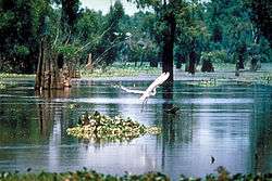
The Atchafalaya Basin,[p] or Atchafalaya Swamp, is the largest wetland and swamp in the United States. Located in south central Louisiana, it is a combination of wetlands and river delta area where the Atchafalaya River and the Gulf of Mexico converge. The river stretches from near Simmesport in the north through parts of eight parishes to the Morgan City area in the south.
The Atchafalaya is unique among Louisiana basins because it has a growing delta system (see illustration) with nearly stable wetlands.[1] The basin contains about 70% forest habitat and about 30% marsh and open water. It contains the largest contiguous block of forested wetlands remaining (about 35%) in the lower Mississippi River valley and the largest block of floodplain forest in the United States. Best known for its iconic cypress-tupelo swamps, at 260,000 acres (110,000 ha), this block of forest represents the largest remaining contiguous tract of coastal cypress in the US.[2]
Geographical features

The Atchafalaya Basin, the surrounding plain of the river, is filled with bayous, bald cypress swamps, and marshes that give way to more brackish estuarine conditions and end in the Spartina grass marshes, near and at where it meets the Gulf of Mexico. It includes the Lower Atchafalaya River, Wax Lake Outlet, Atchafalaya Bay, and the Atchafalaya River and Bayous Chene, Boeuf, and Black navigation channel. See maps and photo views of the Atchafalaya Deltas centered on 29°26′30″N 91°25′00″W / 29.44167°N 91.41667°W.
The Basin, which is susceptible to long periods of deep flooding, is sparsely inhabited. The Basin is about 20 miles (32 km) in width from east to west and 150 miles (240 km) in length.[3] The Basin is the largest existing wetland in the United States with an area of 1,400,000 acres (5,700 km2) including the surrounding swamps outside of the levees that historically were connected to the Basin.[4] The Basin contains nationally significant expanses of bottomland hardwoods, swamplands, bayous, and back-water lakes.[5] The Basin's thousands of acres of forest and farmland are home to the Louisiana black bear (Ursus americanus luteolus), which has been on the United States Fish and Wildlife Service threatened list since 1992.[6]
The few roads that cross it follow the tops of levees. Interstate 10 crosses the basin on elevated pillars on a continuous 18.2 mile (29,290 m) bridge from Grosse Tete, Louisiana, to Henderson, Louisiana, near at the Whiskey River Pilot Channel at 30°21′50″N 91°38′00″W / 30.36389°N 91.63333°W.
The Atchafalaya National Wildlife Refuge was established in 1984 to improve plant communities for endangered and declining species of wildlife, waterfowl, migratory birds and alligators.[7]
Basin geology and flooding
The Atchafalaya Basin has a long relationship with the Mississippi River throughout the Holocene epoch, and the geology of the modern basin has is a direct manifestation of that relationship.[2] The Atchafalaya Basin has been part of three historic depositional lobes (Sale-Cypremort, Teche, and Lafourche lobes) of the Mississippi River Delta Plain that formed south Louisiana, and active delta lobe development is currently occurring at the mouth of the Atchafalaya River and Wax Lake Outlet. The geology of the current basin has been driven by flows of Atchafalaya River water and sediment that flowed into open water areas through relict Mississippi River distributary channels.[2]
The Atchafalaya Basin contains lacustrine and coastal delta landscapes. Natural filling of the basin with sediment was accentuated with the building of the flood control levees that were completed in the 1940s. After the levees, sediment was directed into an area about one-third the size of the original basin. An example of the lacustrine delta development can be seen at Lake Fausse Pointe State Park, where levees severed the connection between the Grand Bayou distributary and the lake, and delta development was frozen in time.[2]
Geologically, the Atchafalaya River has been a backswamp, low area between the paths of the Mississippi River through the process of delta switching, which has built the extensive delta plain of Louisiana. The natural levees of the Mississippi River (on the east) and the levees along its previous course (now Bayou Teche) on the west define the Atchafalaya Basin.[8] The central basin is further bordered by man-made levees designed to contain and funnel floodwaters released from the Mississippi at the Old River Control Structure and the Morganza Spillway south toward Morgan City and eventually to the Gulf of Mexico. Historically there were small and few channel connections to the Mississippi River. The historic lack of significant channel connection indicates that the Atchafalaya River Basin did not receive significant sediment from the Mississippi except during large floods.
During the mid-19th century, manmade channel alterations, including the removal of a large log jam and dredging, permanently connected the Atchafalaya River to the Mississippi River. From then till the completion of the Old River Control Structure in 1963, the Mississippi was increasingly diverting flow into the shorter and steeper path of the Atchafalaya channel. By law, a regulated 30 percent of the latitudinal flow water from the Mississippi, Red and Black rivers is diverted into the Atchafalaya at the Old River Control Structure. This flow diverts on average 25 percent of the Mississippi River flow down the Atchafalaya.
In times of extreme flooding, the US Army Corps of Engineers may open the Morganza Spillway and other spillways to relieve pressure on levees and control structures along the Mississippi. On May 13, 2011, in the face of a rising Mississippi River that threatened to flood New Orleans and other heavily populated parts of Louisiana, the USACE ordered the Morganza Spillway opened for the first time since 1973. This water floods the Atchafalaya Basin between the levees along the western and eastern limits of the Morganza and Atchafalaya basin floodways.
Degradation of the swamps
The control of the river's floods, along with those of the Mississippi River, has become a controversial issue in recent decades. The US Geological Survey (USGS) reports that Mississippi River delta salt marshes are wetlands degrading at a rate of 29 square miles per year.[9] The Atchafalaya River Deltas are the only locations of land growth along the Louisiana Gulf Coast.
During the early 20th century, the Atchafalaya River Basin was designated as a spillway for floods of the Mississippi River. In order to facilitate this emergency plan without flooding adjacent agriculture and towns, protective levees were built dividing the Atchafalaya Basin Floodway from large portions of the historic swamp boundaries. A central channel was dredged through some existing channels and in some places through swamp forest. At that point the isolated Atchaflaya River Basin was permanently connected to a very large, sediment-rich river.[10]
From 1850 to 1950 open water decreased from 490 km^2 to 290 km^2. From 1950 to 2005 the amount of open water decreased to 190 km^2.[10] When the Atchafalaya Basin flow plan was implemented (1950-1974), 30 percent of the total Atchafalaya River flow was designated to be directed off the main channel, 15 percent to the east and 15 percent to the west side. As a result of the Atchafalaya River channel bed incision, in the early 21st century the flow distribution is 13 percent of the total flow, with a flow distribution of 7 percent to the east side and 6 percent to the west side as reported by the USGS. This decrease in flow across the floodplain, in conjunction with high organic deposition from trees and floating vegetation and high water temperature, has resulted in large areas of low-dissolved oxygen water. Where once the water was black (1850), the water became brown (1927). Where the water was formerly brown (1927), it is now black (2009).[11]
During the period of 1960-1980, oil and gas exploration and development in Louisiana increased dramatically. Numerous large access canals and pipeline canals were dredged through deep swamp areas, across bayous, and across the Atchafalaya River. In some areas of the Basin, there are 2 km or more of access canals to every 1 km of natural bayou. These large channels (30–50 m wide by 2–3 m deep) have fundamentally changed the hydrology of the swamps. Deep swamp areas that were hydraulically isolated from sediment were connected directly to the river and its sediment and suffered rapid filling. The USGS has measured sediment deposition rates of up to 30 cm per year where these channels enter open water, and 4 cm per year on adjacent floodplains. In some places natural bayous have filled in due to flow capture by access canals.
Spoil material from the canals was deposited adjacent to the canals, further impeding the natural flow across the floodplain. A 2013 search in Google Earth could find no imagery of any swamp anywhere in the world with as much oil and gas access canal construction as in the Atchafalaya River Basin.
Gallery
-
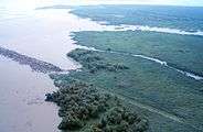
Aerial view of the Big Island Mining Project restoration site on Atchafalaya Bay.
-

View of the south side of the I-10 bridge crossing the basin.
-
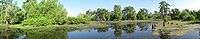
Panorama of the Atchafalaya Basin
See also
- Mississippi River Delta
- Wetlands of Louisiana
- List of Louisiana rivers
- Atchafalaya National Heritage Area
References
^[p] The word "Atchafalaya" is pronounced as "ah-CHAF-fah-Lie-ah".[12]
- ↑ Louisiana Coast
- 1 2 3 4 Piazza, Bryan P. The Atchafalaya River Basin: History and Ecology of an American Wetland. Texas A&M University Press. ISBN 978-1-62349-039-3.
- ↑ Encyclopedia of Cajun Culture
- ↑
- ↑ Audubon Wetlands Campaign Archived April 16, 2009, at the Wayback Machine.
- ↑ Leslie Williams (June 20, 1998). "The Bear Facts Scientists Hot On Trail Of Species". The Times-Picayune. p. A1.
|section=ignored (help) - ↑ Atchafalaya National Wildlife Refuge
- ↑ [Kolb, van Lopik (1958). Geology of the Mississippi River deltaic plain, southeastern Louisiana. Technical Report 3-483. Vicksburg, MS: U.S. Army Corps of Engineers Waterways Experiment Station]
- ↑ USGS Fact Sheet: Louisiana Coastal Wetlands: A Resource At Risk, USGS.gov.
- 1 2 Hale, L., Waldon, M.G., Bryan, C.F., Richards, P.A. (1999). "Historic patterns of Sedimentation in Grand Lake, Louisiana." Proceedings, Recent Research in Coastal Louisiana Natural System Function and Response to Human Influence. Roza, L.P., Nyman, J.A., Proffitt, C.E., Rabalais, N.N., Reed, D.J., and Turner, R.E. (eds). Louisiana Sea Grant, Baton Rouge, La.
- ↑ Eos magazine, March 2009, Moeras van de verdwenen reuzen
- ↑ Moon Handbooks New Orleans: Including Cajun Country, Andrew Collins, 2007, p.324, webpage: Books-Google-FgC.
External links
- The Atchafalaya Heritage Area
- National Weather Service: Atchafalaya Basin
- Satellite view of the Atchafalaya delta on Google maps
- Voices of the Atchafalaya—Documentary featuring pictures and oral histories from the basin.
- Lockwood, C.C. C.C.Lockwood's Atchafalaya. Louisiana State University Press. 2008. ISBN 978-0-8071-3259-3.