Aust-Agder
| Aust-Agder fylke | ||
|---|---|---|
| County | ||
 | ||
| ||
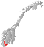 Aust-Agder within Norway | ||
| Country | Norway | |
| County | Aust-Agder | |
| Region | Sørlandet | |
| County ID | NO-09 | |
| Administrative centre | Arendal | |
| Government | ||
| • Governor |
Øystein Djupedal Sosialistisk Venstreparti (2009–present) | |
| • County mayor |
Laila Øygarden Arbeiderpartiet (2007–present) | |
| Area | ||
| • Total | 9,158.15 km2 (3,535.98 sq mi) | |
| • Land | 8,353.31 km2 (3,225.23 sq mi) | |
| • Water | 804.54 km2 (310.63 sq mi) | |
| Area rank | #14 in Norway, 2.73% of Norway's land area | |
| Population (2014) | ||
| • Total | 113.518 | |
| • Rank | 18 (2.26% of country) | |
| • Density | 12/km2 (30/sq mi) | |
| • Change (10 years) | 4.3 % | |
| Demonym(s) | Austegde | |
| Time zone | CET (UTC+01) | |
| • Summer (DST) | CEST (UTC+02) | |
| Official language form | Neutral | |
| Income (per capita) | 135,700 NOK | |
| GDP (per capita) | 208,275 NOK (2001) | |
| GDP national rank | 18 (1.40% of country) | |
| Website | www.austagderfk.no/ | |
|
| ||
Aust-Agder [ˈæʉst ˈɑɡdər] (![]() listen) (East Agder) is a county (fylke) in Norway, bordering Telemark, Rogaland, and Vest-Agder. In 2002, there were 102,945 inhabitants, which is 2.2% of the total population in Norway. Its area is 9,212 square kilometres (3,557 sq mi). The administrative center of the county is in Arendal.
listen) (East Agder) is a county (fylke) in Norway, bordering Telemark, Rogaland, and Vest-Agder. In 2002, there were 102,945 inhabitants, which is 2.2% of the total population in Norway. Its area is 9,212 square kilometres (3,557 sq mi). The administrative center of the county is in Arendal.
The county, which is located at the Skagerrak coast, extends from Gjernestangen at Risør to Kvåsefjorden at Lillesand. The inner parts of the area includes Setesdalsheiene and Austheiene. The majority of the population live near the coast; about 78% of the county's inhabitants live in the five coastal municipalities Arendal, Grimstad, Lillesand, Tvedestrand and Risør. The rest of the county is sparsely populated. Tourism is important, as Arendal and the other coastal towns are popular attractions.
The county includes the islands of Tromøy, Justøya, and Sandøya. The interior of the county encompasses the traditional district of Setesdal, through which the Otra river flows to the coast.
Name
The meaning of the name is "(the) eastern (part of) Agder", since the word aust is the nynorsk form of "east". (see also: the name of Vest-Agder county).
Until 1919, the name of the county was Nedenes amt. The amt was named after the old Nedenes farm (Norse Niðarnes), since this was the seat of the amtmann (County Governor). The first element is the genitive case of the river name Nið (now called Nidelva) and the last element is nes which means "headland". The meaning of the river name is unknown.[1]
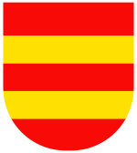
Coat-of-arms
The coat-of-arms is from modern times. They were granted in 1958. It shows two golden bars on a red background. They symbolize the lumber trade and the recovery of iron ore that was important for Aust-Agder's growth.[2]
Municipalities
The system of municipalities, or kommuner, was established in Norway in 1837, based on previously existing parishes. Norway had been ceded to Sweden by Denmark in 1814, at which it promptly rebelled and won the right of self-rule, though nominally part of Sweden. In 1905, Norway declared total independence. Meanwhile, the kommuner did not remain the same, but new ones were formed, old ones broken up, and land was passed between kommuner.
Aust-Agder is divided into 15 municipalities:
| Rank | Name | Inhabitants | Area km² | Map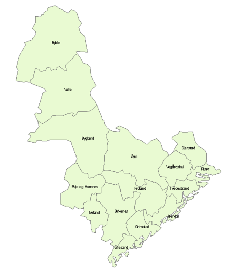 Municipalities of Aust-Agder |
|---|---|---|---|---|
| 1 | |
41,655 | 256 | |
| 2 | |
20,497 | 273 | |
| 3 | |
9,465 | 180 | |
| 4 | |
6,894 | 179 | |
| 5 | |
5,939 | 204 | |
| 6 | |
5,002 | 605 | |
| 7 | |
4,689 | 633 | |
| 8 | |
3,397 | 521 | |
| 9 | |
2,478 | 308 | |
| 10 | |
1,886 | 322 | |
| 11 | |
1,861 | 1,068 | |
| 12 | |
1,289 | 1,135 | |
| 13 | |
1,254 | 250 | |
| 14 | |
1,223 | 1,156 | |
| 15 | |
970 | 1,256 | |
| Total | |
108,499 | 9,158 |
Population
| Historical population | ||
|---|---|---|
| Year | Pop. | ±% |
| 1951 | 75,811 | — |
| 1961 | 77,066 | +1.7% |
| 1971 | 80,839 | +4.9% |
| 1981 | 90,629 | +12.1% |
| 1991 | 97,314 | +7.4% |
| 2001 | 102,714 | +5.5% |
| 2011 | 110,048 | +7.1% |
| 2021? | 126,092 | +14.6% |
| 2031? | 139,982 | +11.0% |
| Source: Statistics Norway.[3] | ||
Since the census of 1769, Aust-Agder has experienced a steady population growth: from 29,633 to 79,927 in 1900, and to 102,848 in 2001. There was significant emigration to the United States in the 19th century and early 20th century.
See also
References
- ↑ Rygh, Oluf (1905). Norske gaardnavne: Nedenes amt (in Norwegian) (8 ed.). Kristiania, Norge: W. C. Fabritius & sønners bogtrikkeri. p. 110.
- ↑ "Fylkesvåpenet" (in Norwegian). Aust-Agder fylkeskommune.
- ↑ Projected population - Statistics Norway
- ↑ Statistics Norway - Church of Norway.
- ↑ Statistics Norway - Members of religious and life stance communities outside the Church of Norway, by religion/life stance. County. 2006-2010
External links
- Political map
- Aust-Agder fylkeskommune (in English)
- Photogallery
-
 Media related to Aust-Agder at Wikimedia Commons
 -
 Aust-Agder travel guide from Wikivoyage
Coordinates: 58°34′00″N 08°34′00″E / 58.56667°N 8.56667°E
| Counties | ||
|---|---|---|
| Cities | ||
| Towns | ||
| Municipalities | ||