Auvers, Manche
| Auvers | |
|---|---|
|
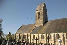
Saint-Étienne church and the château | |
 Auvers | |
|
Location within Normandy region  Auvers | |
| Coordinates: 49°17′59″N 1°19′07″W / 49.2997°N 1.3186°WCoordinates: 49°17′59″N 1°19′07″W / 49.2997°N 1.3186°W | |
| Country | France |
| Region | Normandy |
| Department | Manche |
| Arrondissement | Saint-Lô |
| Canton | Carentan |
| Intercommunality | Carentan-en-Cotentin |
| Government | |
| • Mayor (2008–2014) | Guy Foucher |
| Area1 | 18.76 km2 (7.24 sq mi) |
| Population (2009)2 | 662 |
| • Density | 35/km2 (91/sq mi) |
| Time zone | CET (UTC+1) |
| • Summer (DST) | CEST (UTC+2) |
| INSEE/Postal code | 50023 / 50500 |
| Elevation |
0–26 m (0–85 ft) (avg. 5 m or 16 ft) |
|
1 French Land Register data, which excludes lakes, ponds, glaciers > 1 km² (0.386 sq mi or 247 acres) and river estuaries. 2 Population without double counting: residents of multiple communes (e.g., students and military personnel) only counted once. | |
Auvers is a commune in the Manche department in the Basse-Normandie region in northwestern France.
Population
| Historical population | ||
|---|---|---|
| Year | Pop. | ±% |
| 1793 | 1,186 | — |
| 1800 | 1,266 | +6.7% |
| 1806 | 1,316 | +3.9% |
| 1821 | 1,306 | −0.8% |
| 1831 | 1,224 | −6.3% |
| 1836 | 1,215 | −0.7% |
| 1841 | 1,205 | −0.8% |
| 1846 | 1,194 | −0.9% |
| 1851 | 1,212 | +1.5% |
| 1856 | 1,168 | −3.6% |
| 1861 | 1,153 | −1.3% |
| 1866 | 1,141 | −1.0% |
| 1872 | 1,077 | −5.6% |
| 1876 | 1,133 | +5.2% |
| 1881 | 1,122 | −1.0% |
| 1886 | 1,104 | −1.6% |
| 1891 | 1,044 | −5.4% |
| 1896 | 1,014 | −2.9% |
| 1901 | 887 | −12.5% |
| 1906 | 884 | −0.3% |
| 1911 | 807 | −8.7% |
| 1921 | 676 | −16.2% |
| 1926 | 664 | −1.8% |
| 1931 | 656 | −1.2% |
| 1936 | 657 | +0.2% |
| 1946 | 663 | +0.9% |
| 1954 | 766 | +15.5% |
| 1962 | 675 | −11.9% |
| 1968 | 627 | −7.1% |
| 1975 | 573 | −8.6% |
| 1982 | 563 | −1.7% |
| 1990 | 571 | +1.4% |
| 1999 | 589 | +3.2% |
| 2009 | 662 | +12.4% |
See also
References
| Wikimedia Commons has media related to Auvers (Manche). |
This article is issued from Wikipedia - version of the 8/16/2016. The text is available under the Creative Commons Attribution/Share Alike but additional terms may apply for the media files.