Auxais
| Auxais | |
|---|---|
|
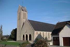
Notre-Dame church after reconstruction | |
 Auxais | |
|
Location within Normandy region  Auxais | |
| Coordinates: 49°12′50″N 1°17′51″W / 49.2139°N 1.2975°WCoordinates: 49°12′50″N 1°17′51″W / 49.2139°N 1.2975°W | |
| Country | France |
| Region | Normandy |
| Department | Manche |
| Arrondissement | Saint-Lô |
| Canton | Carentan |
| Intercommunality | Sèves et Taute |
| Government | |
| • Mayor (2008–2014) | Marcel Laisney |
| Area1 | 7.76 km2 (3.00 sq mi) |
| Population (2009)2 | 181 |
| • Density | 23/km2 (60/sq mi) |
| Time zone | CET (UTC+1) |
| • Summer (DST) | CEST (UTC+2) |
| INSEE/Postal code | 50024 / 50500 |
| Elevation |
2–19 m (6.6–62.3 ft) (avg. 16 m or 52 ft) |
|
1 French Land Register data, which excludes lakes, ponds, glaciers > 1 km² (0.386 sq mi or 247 acres) and river estuaries. 2 Population without double counting: residents of multiple communes (e.g., students and military personnel) only counted once. | |
Auxais (French pronunciation: [o.seː]) is a commune in the Manche department in the Basse-Normandie region in northwestern France.
Population
The inhabitants are called Auxerons.
| Historical population | ||
|---|---|---|
| Year | Pop. | ±% |
| 1793 | 615 | — |
| 1800 | 555 | −9.8% |
| 1806 | 501 | −9.7% |
| 1821 | 512 | +2.2% |
| 1831 | 473 | −7.6% |
| 1836 | 473 | +0.0% |
| 1841 | 416 | −12.1% |
| 1846 | 429 | +3.1% |
| 1851 | 393 | −8.4% |
| 1856 | 405 | +3.1% |
| 1861 | 396 | −2.2% |
| 1866 | 375 | −5.3% |
| 1872 | 357 | −4.8% |
| 1876 | 349 | −2.2% |
| 1881 | 307 | −12.0% |
| 1886 | 307 | +0.0% |
| 1891 | 273 | −11.1% |
| 1896 | 282 | +3.3% |
| 1901 | 295 | +4.6% |
| 1906 | 276 | −6.4% |
| 1911 | 279 | +1.1% |
| 1921 | 243 | −12.9% |
| 1926 | 248 | +2.1% |
| 1931 | 236 | −4.8% |
| 1936 | 245 | +3.8% |
| 1946 | 218 | −11.0% |
| 1954 | 241 | +10.6% |
| 1962 | 205 | −14.9% |
| 1968 | 180 | −12.2% |
| 1975 | 156 | −13.3% |
| 1982 | 135 | −13.5% |
| 1990 | 130 | −3.7% |
| 1999 | 137 | +5.4% |
| 2009 | 181 | +32.1% |
See also
References
| Wikimedia Commons has media related to Auxais. |
This article is issued from Wikipedia - version of the 9/16/2015. The text is available under the Creative Commons Attribution/Share Alike but additional terms may apply for the media files.